Archive for the ‘ ~REHOBOTH MA~ ’ Category

Pemmerl Town Trails – Rehoboth

  • Pemmerl Town Trails
  • Danforth Street, Rehoboth, MA
  • Trailhead:  41°51’28.02″N, 71°15’47.04″W
  • Last Time Hiked: October 21, 2022
  • Approximate distance hiked: 3.7 miles
  • Moderate with some elevation.

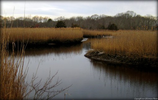
A recently developed parking area and a small handmade sign reading “Pemmerl Town Trails” is what I stumbled upon while doing some country road driving. What a great find!! The property is quite large and has a small network of trails at the southern end and a long meandering trail that reaches into the northern end and beyond. At the time of this hike the trails we marked with some occasional flagging indicating to me that there may be more improvements to come. Each intersection was well marked with homemade signs. I did stumble upon a map of the property artistically portrayed on one of the homemade signs. I explored the yellow “Cliff Walk Trail” with its wonderful ledges and outcrops, the high point of Counsel Rock, the orange “Winter View Trail” where in spots you have to get on your hands and knees to crawl and climb to reach the “LedgEdge”, and the green “Main Trail” which winds through the property to Perryville Pond. The blue “West Palmer River Trail” crosses private property, however there is a sign that seems to welcome visitors to use it. This is a beautiful trail that winds through areas of boulders, into low laying marsh, before coming to the banks of the river. At the pond there is a dam and waterfall. Be sure to use your GPS here as the trails are only marked at the intersections. And do respect private properties as there are unmarked trails that lead off the property.

TWRI-Pemmerl03

West Palmer River

TWRI_PemMap

Map of Pemmerl Town Trails

Redway Plain – Rehoboth


Once used for militia training and also used to grow crops, this fairly large field off of Route 44 is today home to the Rehoboth Veterans Memorial and an occasional town event such as a carnival. Its name, Redway Plain, is derived from the early settler James Redway. For most of the year the field is left to grow and a walking path is mowed around its perimeter. Walking and horseback riding is welcome here along the perimeter. The recent addition of the Veterans Memorial pays homage to all the residents of Rehoboth who have served in all the American Wars from 1620 to current day.

TWRI-Redway2

Summer Day at Redway Plain

Shad Factory Pond – Rehoboth

  • Shad Factory Pond/Daniel L. Savoie Conservation Area
  • Water Street, Rehoboth, MA
  • Trailhead: 41°48’31.54″N, 71°16’29.51″W
  • Last Time Hiked: February 5, 2017
  • Approximate distance hiked: 0.7 miles
  • Easy.


This walk, just about three quarters of a mile, features a trail that follows the Palmer River and a short stroll to the Shad Factory Pond and its dam. Starting from the parking area along Water street, follow the narrow unmarked trail easterly along the river. The river here is covered in a canopy of trees that birds were flying through. Cardinals, blue jays, robins, woodpeckers, and ducks were all seen along the trail here. Along the way there is an old wooden structure that looks as if it might have been a dock or bridge. The trail ends at Reed Street opposite the entrance to a service road. This road is closed to the public as it is property of the Bristol County Water Authority. From here follow Reed Street south a few hundred feet crossing the Palmer River. To the right you will catch glimpses of some ruins that were once part of the Orleans Mill. You will see a couple of the remaining walls and a double archway over the river. This mill produce cotton cloth but met its untimely fate twice by fire. Some people have claimed that the old mill site is haunted and have seen unexplained figures in the woods. Just over the bridge and on the right as well is Shad Factory Pond with its 1911 dam and newly constructed fish ladder. There are a handful of benches here to sit and relax. From here retrace your steps along Reed Street and along the trail back to the parking area. If you are into bird photography, bring your camera.

twri-shad

Palmer River just downstream from Shad Factory Pond

Mason Street – Rehoboth


A short grass cut farm road leads you down to the shores of the Palmer River from Mason Street. This property owned by the Rehoboth Land Trust features a large corn field. The road is flanked by tall grasses, shrubs, and sporadic trees. This creates a haven for small critters and birds. At the end of the farm road the Palmer River winds through the grasslands.

twri-mason

Palmer River at the Mason Street Conservation Area

Rehoboth Town Forest – Rehoboth


This short mile and a half hike actually crosses two properties. This first property is privately owned by the Oak Hill Beagle Club and through a conservation easement the public is allowed to use the trail that crosses their land to get to the Rehoboth Town Forest. There are two marked trails in the forest that were blazed as an Eagle Scout project by Rehoboth’s Troop 13 Jeff Muri. The main trail is blazed red and continues to (and beyond) the back property line. After passing a sitting bench the red trail comes to another intersection. Here you will see a trail ahead that is much more overgrown. There is a sign on a tree to the right reading “End of Public Property”. To your left you will see a trail that is blazed blue. This trail, very rocky in areas, loops back around, up a hill, and along the edge of a field before coming back out to the sitting bench. Turn right here and retrace your steps back to the parking area.

TWRI-8-Rehoboth

Along The Red Trail

Ephraim Hunt – Rehoboth

  • Ephraim Hunt Ministerial Land
  • Pond Street, Rehoboth, MA
  • Trailhead: 41°50’8.75″N, 71°16’10.04″W
  • First Time Hiked: June 17, 2014
  • Last Time Hiked: April 20, 2018
  • Approximate distance hiked: 1.5 miles
  • Easy with slight elevation.


This is a small but quite quaint property in Rehoboth. There are three blazed trails on the property. A red blazed loop trail that wraps around an outdoor classroom. The blue blazed trail that travels to the back reaches of the property and an orange out and back trail that runs through an old field. There is a stream here crossed by boardwalks and plenty of birdhouses.


Trail map can be found at: Ephraim Hunt.

Along The Blue Trail

Along The Blue Trail

Rehoboth State Forest – Rehoboth


This hike made for a few milestones. Firstly, without realizing it I hiked in four states in three days. On Saturday I drove to Franconia Notch in New Hampshire, on Sunday I did a series of hikes in Rhode Island and Connecticut, and this evening I hiked here in Massachusetts. Secondarily, this hike put me over the 300 mile mark since I started this blog. I was joined by a co-worker (who is one of the organizers of The Rhode Island Hiking Club). We started this hike following the main path pass the gate into the forest. We passed several narrow paths to the left and one trail to the right (we would return from that trail) following the main trail to its end. There we saw the first of the blue blazes to the right. The trail to the left ended abruptly at a “No Trespassing” sign. We went right following the blue blazes through the woods and some areas of mud. The trail eventually looped back to the main trail. We then did some exploring of the side trails we saw on the way in. There was evidence of a “Tough Mudder” event here. We also came across some lady slippers that were in bloom. It is illegal to remove these flowers. After we explored just about all of the trails we concluded the hike.


Trail map can be found at: Rehoboth State Forest.

Stone Wall At Rehoboth State Forest

Stone Wall At Rehoboth State Forest


Anawan Rock – Rehoboth


Anawan Rock is more of a historic site than a hike. There is a trail here nonetheless. Without any doubt, this is the shortest hike on my list of both completed and planned hikes. The trail runs from the parking area a couple hundred feet then lollipops around the rock itself. The rest of the property is wooded. The historical significance of the site is the role it served during King Phillips War. In August 1676, the Wampanoag chief was captured at this site by the colonists effectively ending the bloody war between the two. The rock itself, a puddingstone, is quite large. Out of curiosity I did climb it. Unfortunately, the trees are taller than the rock so there is not much of a scenic view other than the immediate property.


I did not find a trail map on-line.

Anawan Rock

Anawan Rock

Miller Bird Sanctuary – Rehoboth


A short and easy walk in a quiet neighborhood in Rehoboth. There is a small pull off on Lake Street just north of Winter Street where the trailhead is to park. I entered the sanctuary and immediately was greeted by a sign with a trail map. I opted to follow the red loop first which has a wooden bridge crossing a stream and wound through some heavily wooded areas. I came across another sign along this path that is quite interesting. It describes the type of footprints of various native animals. I then turned right onto the short white trail which looped back to the red trail where I turned right to finish the loop. After coming back and crossing the wooden bridge. I turned left and followed the blue trail to its end, turned around and came back. I then finished the hike making my way back to the car. I only saw a few ducks and chipmunks on this hike.

Wooden Bridge

Wooden Bridge