- Narragansett Trail
- North Stonington, CT to Hopkinton, RI
- Last Time Hiked: 2017
- Approximate Distance: 20.6 miles (open sections)
- Difficultly is determined by individual legs of the hike.
Established in the early 1930’s and completed by 1936, the Narragansett Trail was one of the longest trails in the area. The original route ran from Lantern Hill in North Stonington, Connecticut to Wordens Pond in South Kingstown, Rhode Island. Today, the Narragansett Trail ends at Ashville Pond in Hopkinton, Rhode Island. Unfortunately, the trail is closed in some sections, partly temporary and partly permanent, and has become non-continuous. The temporary closure is due to clearing of land and the trail should re-open in due time. The permanent closure is on the land of the Groton Sportmans Club. The Connecticut Forest And Park Association has temporarily re-routed that section of trail along roads. Nonetheless, this trail is hands down one of the best hiking trails in Southern New England. The trail is blazed light blue in Connecticut and yellow in Rhode Island. This hike was done as a one-way hike using car-stops.

A Beaver Hut Along The Narragansett Trail
~~~
- Wintechog Hill Road to North Stonington Transfer Station
- Features Lantern Hill
- North Stonington, CT
- Trailhead: 41°28’0.82″N, 71°56’44.18″W
- Last Time Hiked: April 17, 2017
- Approximate distance hiked: 1.9 miles
- Difficult to Strenuous With Some Climbing.
The western most portion of the Narragansett Trail climbs over Lantern Hill just southeast of the Foxwoods Casino complex. Starting from a makeshift parking area (with no signage) along Wintechog Hill Road the light blue blazed trail immediately begins to climb the hill following an old cart-path. After a couple hundred feet the trail levels off for a bit before coming to a red blazed Lantern Hill Loop Trail. Be sure to be aware of the blue blazes of the Narragansett Trail when you approach trail intersections. You will want to follow them and not the red blazes for this hike. The Narragansett Trail then starts to steadily climb the hill once again. The inclines are quite impressive at times. The trail first overlooks the Pequot Reservation to the north and west offering views of the casino and Lantern Hill Pond below. The trail then climbs over the summit to a stunning overlook with miles and miles of sights to the east and south. Clear days will offer a view of the Atlantic Ocean to the south. It is also interesting to see the hawks and vultures soaring through the sky sometimes below you. Use extreme caution along the edges here as a fall would surely be fatal. Also here on the first day of Spring the Westerly Morris Men climb the hill for their annual sunrise dance at the summit. The hill got its name from the War of 1812 as the hill was used as a lookout. When the British were spotted approaching, barrels of tar were ignited to warn nearby residents. After spending some time at the summit continue following the blue blazed trail as it winds, at times steeply, down the hill. There is one section, that we dubbed the Lemon Squeeze, that will challenge your footing, balance, and upper body strength. The trail then traverses the south side of the hill passing through groves of mountain laurel before coming out to the North Stonington Transfer Station. Again, be sure to pay attention to blazes and turns at intersections. After the Dog Pound the trail turns to the left through the transfer station and back out to Wintechog Hill Road. At this point you have hiked 1.4 miles of the Narragansett Trail. The trail continues ahead, however it is closed (from Wintechog Hill Road to Route 2) at the moment because of logging.
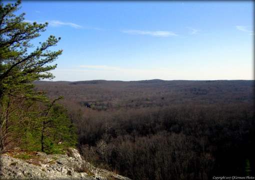
The View Looking East From Lantern Hill.
~~~
This section of the Narragansett Trail is temporarily closed and is due to re-open in the near future.

~~~
- Ryder Road to Wyassup Lake
- Features Gladys Foster Preserve & Cossaduck Bluffs
- North Stonington, CT
- Trailhead: 41°27’42.11″N, 71°54’21.83″W
- Last Time Hiked: May 21, 2017
- Approximate distance hiked: 3.5 miles
- Moderate to Difficult, Long uphill section, stream crossings.
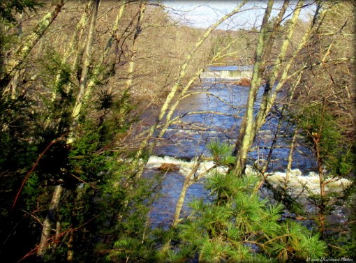
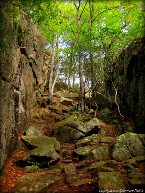
The blue blazed Narragansett Trail continues from Ryder Road easterly passing a small Nature Conservancy property known as the Gladys Foster Preserve. The trail then starts a climb up Cossaduck Hill. This section of the trail can be quite difficult as there is a quick increase in elevation. There are some impressive outcrops and ledges along this stretch as you climb toward an outlook known as Cossaduck Bluffs. Some locals also call it the Yawbux Valley Overlook. The view to the south here is quite impressive. The trail then winds slightly downhill passing some stone walls and entering the Pachaug State Forest. The trail then comes to an intersection where you need to take a left and then an immediate right. Be sure to follow the blue blazes. The trail steadily continues downhill passing through pine groves and beech stands. Along this stretch we came upon wild geranium and reishi mushroom. After a steep decline we came to the first of a few major crossings of the Yawbux Brook. Be sure to look for and follow the blazes by the brook. And furthermore, prepare to get your feet wet and/or muddy after heavy rains. After a bit of rock hopping over the brook the trail gets rocky and root-bound as well before coming to the second brook crossing. This one is a pair of logs that are quite rickety. A pair of trekking poles or a hiking stick will serve you well here. Again be sure to find and follow the blazes. The trail then winds through a wet and muddy area conducive for the growth of ferns before taking a well marked right turn, through a stone wall, and over the Yawbux Brook once again via a series of large “stepping stones”. The trail then turns to the left and through a short section that is a little overgrown before coming out to a beaver pond complete with a beaver dam and beaver hut. The trail then follows the shore of the pond for a bit passing swamp azalea, wild dogwood, and lady-slippers. An osprey and several swallows were spotted above the pond. No beavers were seen, but several trees had been toppled by their signature mark. The trail then continues into the thick woods and eventually through another pine grove. The trail at times is covered in their needles. More areas of outcrops and stone walls are along the rocky trail before coming to the Wyassup Road Spur. This trail leads into the new Stewart Hill Preserve. Continuing to follow the blue blazed Narragansett Trail we soon came to the last brook crossing. This one was quite wide and rocky, but at the time somewhat dry. After a heavy rain this one may be nearly impassable. The trail soon crosses an old cart path and continues to wind through the forest flanked by more outcrops and stone walls before coming out to Wyassup Lake Road just opposite of the boat ramp and parking area for the lake.

“Stepping Stones” Crossing The Yawbux Brook.
~~~
- Wyassup Lake to Pendleton Hill Road
- Features High Ledge & Bullet Ledge
- North Stonington/Voluntown, CT
- Trailhead: 41°29’20.79″N, 71°52’37.14″W
- Last Time Hiked: June 17, 2017
- Approximate distance hiked: 4.5 miles
- Difficult, Strenuous in areas, stream crossings.
The blue blazed Narragansett Trail continues from Wyassup Lake first following Wyassup Lake Road northerly a few hundred feet before veering left into the woods onto a trail just beyond a gate. The old road soon turns to the left, continue straight onto a narrower trail and be sure to follow the blue blazes. This trail becomes root bound and rocky as it passes a swampy area with a couple stream crossings. The trail soon passes the first of several stone walls before winding to a massive ledge. This is the base of High Ledge and the Narragansett Trail weaves around the left side of it to its summit. At the summit of High Ledge you can catch a glimpse of the forest to the south. Continuing, the trail then descends dramatically into a fern filled valley with a stream and massive ledges to the left. The trail then follows a ridge line that towers over the forest to the right as it winds to Ledgen Wood Road. Some of the road, an old cart path, tends to be quite rocky and makes for some difficult footing. Soon the Narragansett Trail turns left onto another old cart path and starts in a northerly direction. The trail winds downhill and narrows as it approaches a swampy area that is the headwaters of Dark Hollow Brook. You soon come to another massive ledge, and again the blue blazed trail winds up and around the left side of it. About halfway up the ledge along the trail there are openings to Bear Cave. When you reach the summit of Bullet Ledge you can take a peak to the trail down below. Be careful by the edges. From here, continue to follow the blue blazes as the trail continues to be hilly and substantially rocky. Along this stretch you will pass another large ledge to the left and several boulders, crossing into Voluntown, before coming to Coal Pit Hill Road. The trail continues ahead, crossing the road, and becomes narrower and slightly overgrown. Be sure to keep an eye for the blazes along this stretch. The trail then heads generally northeast passing stone walls and a forest floor of ferns as it winds up and down hills. As the trail turns east it starts a 150 foot descent down a narrow trail towards Myron Kinney Brook. The trail then turns south and starts climbing back uphill following the brook. Along this stretch you will see several small waterfalls and cascades as well as a couple of cairns as the trail crosses back into North Stonington. At the end of the trail, you will turn left at a stone wall onto Ledgen Wood Road once again. The gravel road heads east and soon becomes pavement entering a residential neighborhood. At the intersection continue straight onto Johnson Road. The road gently curves to the right and just before Pendleton Hill Road is a small pull-off for parking.
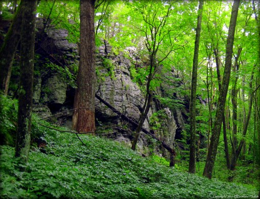
Ledge in a Valley (Note the mountain laurel shrub growing on the side for perspective.)
~~~
- Pendleton Hill Road to Tom Wheeler Road
- North Stonington/Voluntown, CT
- Trailhead: 41°30’30.57″N, 71°50’24.02″W
- Last Time Hiked: July 15, 2017
- Approximate distance hiked: 2.2 miles
- Fairly easy. All road walking, detour of closed section of trail.
The Narragansett Trail has been closed on the property of the Groton Sportsman Club and has been re-routed by The Connecticut Forest And Park Association. Though this detour is not blazed it is easy enough to follow. Starting from a small parking pull-off at the intersection of Pendleton Hill Road and Johnson Road follow Johnson Road to the northwest and then follow it to the right and back out to Pendleton Hill Road. It is advisable to face traffic for this stretch of the hike as you are now walking on a section of Route 49. Be sure to be aware of traffic. Continuing north you soon enter Voluntown and for a little over a half mile you will pass stone walls, farms, fields, and a few houses before coming to Sand Hill Road where you will turn right. This road is much quieter and offers a couple of sights. On the left is Studio Farm with its barn, wishing well, and canine greeter! The road crosses Koistenen Brook and soon starts climbing uphill flanked by post and wire guardrails and stonewalls. After cresting the hill there is a small pond on the right with lily-pads and a large field of wildflowers on the left. The road then turns to the left and immediately to the right. Here at this zigzag is the beginning of Gallup Road and a homestead with a couple small farm buildings. Be sure to continue east along Sand Hill Road for another 300 feet passing a small pond on the right. Here you will turn right onto Tom Wheeler Road and follow it four tenths of a mile passing more stone walls and corn fields. Look for a bright yellow sign on the right reading “Private Shooting Area”. Almost directly across the street from it you will see a sign for the Narragansett Trail. This is where the detour ends and the trail makes it way back into the woods.

Detour

A Field Along Sand Hill Road.
~~~
- Tom Wheeler Road to State Line Marker
- Features Green Fall Pond & Dinosaur Caves
- Voluntown, CT/Hopkinton, RI
- Trailhead: 41°30’51.62″N, 71°49’23.84″W
- Last Time Hiked: July 15, 2017
- Approximate distance hiked: 4.0 miles
- Difficult, Strenuous in areas, stream crossings, rock climbing.
The blue blazed Narragansett Trail continues from Tom Wheeler Road heading in a northeasterly direction. The trail is fairly level at first, but rocky and muddy in areas. After crossing the first of several stream crossings the trail descends down the first rock wall into a small valley of boulders and ledges. Some of the stream crossings can be a bit challenging and almost all of them are cascading with small waterfalls. The trail then follows a long narrow outcrop for a bit and through a grove of mountain laurel before coming out to Sand Hill Road. Turn right here and follow Sand Hill Road several hundred feet to Green Fall River. Just before the road crosses the river turn left onto the trail. Follow the blue blazed trail through an area of hemlocks and soon you will come to a cairn. In this area the blue blazed trail enters into the Green Fall Gorge. The river in the gorge rushes over boulders as the narrow trail climbs up and down the narrow and steep embankments. There is a new bridge, built in the summer of 2017, that replaces a tricky river crossing in the gorge. Before the bridge, the crossing was logs that tended to be slippery. As the trail continues you soon come to the dam and waterfall of Green Fall Pond. The trail climbs up the bank on the right side of the dam to the pond. Swimming is not allowed at this end of the pond but the spot makes for a good resting location before carrying on. The Narragansett Trail now joins the Green Fall Pond trail and is blazed both blue and orange along the shore of the pond. The trail first crosses over a dike before coming to a split. Stay to the left and continue to follow the blue blazes. Soon you will come to the “Tree Bridge”, a small wooden bridge that crosses the Green Fall River that has a tree in the middle of it. Shortly thereafter, the trail splits again. Be sure to follow the blue blazes to the right to stay on the Narragansett Trail. The blue/orange blazes that continue ahead are part of the Narragansett Crossover Trail. You no longer want to follow the orange marks. After making your turn you will head east for just under a mile to the Rhode Island border. Along the way, the trail becomes challenging in areas crossing the Green Fall River again and the Peg Mill Brook. At the brook is an old sluice where the Peg Mill once stood. The water seems to vanish into the ground here. A few feet up and around the bend the water reappears trickling out of the rocks creating waterfalls. The trail then comes to a large set of outcrops with deep crevices. It is best to sit and slide down the rocks here as they tend to be quite high and sometimes slippery. The trails then crosses a small boardwalk, up another hill and soon joins the Tippecansett Trail. Stay to the right. From here the trail is now blazed blue and yellow and follows the Connecticut/Rhode Island border weaving from side to side. Along the way is a spot known as Dinosaur Caves. The Narragansett Trails traverses over the hump of the massive outcrop. The caves are below that can be accessed from a spur trail after climbing over the outcrop. After Dinosaur Caves, the trail becomes significantly easier as it winds down to Camp Yawgoog Road. Across the road from the small parking area in the large granite State Line Marker between Voluntown, Connecticut and Hopkinton, Rhode Island. The blue blazes of the Narragansett Trail ends here as you leave Connecticut. The Narragansett Trail is blazed yellow the remainder of the way into Rhode Island.

In The Green Fall Gorge (note the trail blazes on the right of the river)
~~~
- State Line Marker to Ashville Pond
- Features Camp Yawgoog, Long Pond, & Ashville Pond
- Hopkinton, RI
- Trailhead: 41°31’36.64″N, 71°47’31.82″W
- Last Time Hiked: September 23, 2017
- Approximate distance hiked: 4.8 miles (including spur to overlook)
- Difficult, Strenuous in areas with some rock climbing.
The Narragansett Trail continues from the State Line Marker, now blazed yellow, easterly along Camp Yawgoog Road for about two tenths of a mile. The trail then turns right, opposite the Hidden Lake trail-head, into Camp Yawgoog. From here the trail continues through the Boy Scout Camp along the western shore of Yawgoog Pond passing over a few small streams and areas of boulders. The stream crossings are well maintained with log and timber bridges. The Narragansett Trail along this side of the camp is part of the “Round The Pond Trail”. A green blazed trail appears on the right, continue ahead on the yellow blazed. The trail soon nears the pond where you can get a good look of the pond. Across the way you can see the beaches used by the Boy Scouts They are Sandy Beach, Medicine Bow, and Three Point. Continuing, the trail passes by Blueberry Swamp and through groves of mountain laurel before coming to Cooning Orchard. This area is where several of the camps trails intersect. The Narraganset Trail is now joined by the red blazed trail for a while. This is the “George Utter Trail” and will be blazed both yellow and red for a short section passing through more mountain laurel and rhododendrons. The red trail soon turns right to the Rim Trail and the Richmond Boulder Field. Continue to follow the yellow blazes of the Narragansett Trail and you will soon come to North Road where you will turn left. Following the road to the east for about two tenths of a mile, you will come to a small parking area for Long Pond /Ell Pond. The remainder of this hike is on the property of the Nature Conservancy, the Audubon Society, and the Department of Environmental Management. Turning right and through the small parking area, continue to follow the yellow blazes. The trail now heads into one of the states most densely populated areas of mountain laurel. In mid June, this stretch is stunningly beautiful. In fact, it is one of the most beautiful stretches of trail, not only in Rhode Island, but in New England. The hike also gets substantially more difficult, at times strenuous, from this point forward. The trail starts to climb steadily uphill, scrambling up rock outcrops and wooden stairs. The well intended “No Rock Climbing” signs tend to be a little bit humorous as parts of the trail you have no choice but to climb down and/or up rocks. With that being said, watch your step as you climb down into a small valley before scurrying back up a large outcrop. At the top of the hill there is a small area that opens up. The blaze indicates that the Narragansett Trail turns to the right. But if you have come this far, you are in the “neighborhood” of quite possibly the most beautiful sight in Rhode Island. A spur trail, that is not blazed, leads to the left. It is highly suggested to take the time and explore this trail as it leads down and then back up to a massive ledge. When you approach the wall of rock, stay to the left of it, as there is a way up the left side of it. Choose your steps carefully and exercise caution. Once to the top, take a breather and stay a while. The view is stunning as it overlooks Long Pond. A scene in the movie Moonrise Kingdom was filmed high upon this ledge. After taking in the sights retrace you steps back to the yellow blazed Narragansett Trail to continue the hike. The trail next traverses down a large, beautiful cleft that competes with some natural wonders of the mountains of Northern New England. After descending to the base the trail becomes a boardwalk that crosses a swampy area and stream that connects Ell Pond to Long Pond. At the end of the boardwalk the trail climbs the first of three quite substantial hills. Take your time here and take breaks as needed. This stretch will test your stamina and muscles. With Long Pond now to your left the trail continues to climb up and over a few hills. At times you may need to crawl or climb. The trail eventually levels out some, though hills will remain common, they are just smaller. The trail soon follows large sections of outcrop surrounded by the woods. Large boulders become prevalent with one, looking like the front of a ship, standing out. Stone walls appear on your right as Long Pond vanishes on the left and soon you come to the Canonchet Road trail head. The Narragansett Trail continues, still yellow blazed and bending to the right, making a short westerly loop before turning to the east once again. More stone walls and boulders are a common sight along this last stretch. The trail comes to a large flat outcrop where you turn to the right and then cross a rather high boardwalk. Soon you will get your first glimpses of Ashville Pond to the left. The trail turns to the right near the former Ashville Pond Beach and ends at the parking area on Stubtown Road.
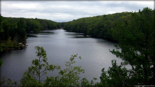
Long Pond From The Overlook
The Cleft
Trail map can be found at: Narragansett Trail (courtesy of Auntie Beak)
I would like to thank Auntie Beak for her help with the planning and logistics of this hike. It has been a pleasure to take on the Narragansett Trail with you. I look forward to tackling more long distance trails with you in the future.
For more photos of this hike, please go to the Trails and Walks Facebook page.