- Historic Providence
- Bridge Street, Providence, RI
- Start of Walk: 41°48’59.45″N, 71°24’3.03″W
- Last Time Hiked: June 3, 2018
- Approximate distance hiked: 5.5 miles
- City walk, moderate due to some steep hills.
“…Providence, the one in Rhode Island, where the old world shadows hang heavy in the air…*“. Nearly four hundred years of history, art, architecture, and culture will be explored on this five and half mile walk. It will lead you along the Providence Waterfront, up College Hill, along Waterplace Park, and will follow parts of the Independence Trail, Lovecraft’s Walking Tour, and the IVV/Ava Historic College 5k route. This walk will wind in and out quaint historical residential neighborhoods, by some of the countries oldest churches, into the heart of Brown University and the Rhode Island School of Design, through city parks, by government buildings, between the towers of glass and steel, and along the rivers that converge in the city, all for a unique perspective of Providence.
Providence, founded by Roger Williams in 1636, was built on seven hills and this walk will visit four of them. With that being said the walk includes steep inclines and descents as well as stairs in several areas. This walk could test your stamina and leg muscles at times, but the numerous historical sites along the way will give you a chance to rest.
Many spots along the route are on cobblestone roads and uneven brick walkways. A comfortable pair of shoes is recommended for this walk. This walk can start/end anywhere along the described route as it is a loop. It was chosen to start at Bridge Street as it was a group hike led on a Sunday morning and parking is readily available in this area.

Roger Williams Statue Overlooking Providence
Starting from Mile End Cove, a small city park at the intersection of Bridge Street and Tockwotten Street, you can catch a glimpse of the Downtown Providence skyline to the north and the iconic smokestacks of the Manchester Street Power Plant to the west. This power plant originally built in 1903 was converted to natural gas in 1995 and is one of the cleanest power plants in New England. It was once part of the sprawling Narragansett Electric property that consisted of several buildings along the river.
Walking south along Bridge Street you will first pass through the large flood gate of the Fox Point Hurricane Barrier before going under the Iway Bridge. The hurricane barrier was built in the early 1960’s (completed in 1966) to protect the downtown area from storm surges. The city was inundated on several occasions prior to the building of the barrier, including in 1938, and again in 1954 by strong hurricanes. The barrier, since its construction, has successively protected the city on several occasions including Hurricane Gloria in 1985, Hurricane Bob in 1991, Hurricane Irene in 2011, and lastly Super-storm Sandy in 2012. The flood gates are also closed occasionally for Waterfire to keep the river level high enough for the event.
The Iway Bridge, built at Quonset Point 15 miles south, was “floated” up the bay and put into place in August of 2006. The bridge opened in November of 2007 and carries the relocated Interstate 195 south of downtown. The bridge in total is 1,250 long with the main span being a 400 foot long network arch. The bridge is illuminated each night until 11 P.M. The bridge serves not only as part of the highway, but as an inviting “gateway” to the Downtown area.

View of Providence From The Harbor.
After passing under the “Iway”, Bridge Street turns to the left onto India Street. Here at the bend on the right are where the tugs of McAllister Towing (Providence Steamship) are kept. This point of land is also the “actual” Fox Point. These tugs guide large cargo ships, tankers, and barges up and down Narragansett Bay from and to the Port of Providence to the waters south of Newport. There are currently six tugs in use on Narragansett Bay.
Walking easterly along India Street you will notice Interstate 195 to the left built up upon a long wall. The highway is used as part of the Hurricane Barrier to protect the city from flooding. Note at each underpass that large flood gates can be closed. On the right you will come to a concrete structure that was once a thriving nightclub in the late 1980’s. Today the remains of this building and nearby parking area are used as the Providence terminal of Seastreak, the operators of the Providence-Newport High Speed Ferry. The ferry ride itself is about an hour long and offers great sights of lighthouses, islands, and the shoreline up and down the bay.
Just after the ferry terminal on the right is the Community Boating Center. On any given summer day you may catch a glimpse of several sail boats off of India Point Park. The boating center is where one can take sailing lessons. In fact, the waters in this area commonly are shared by tug boats, cabin cruisers, sailboats, and kayaks.

Tug Boats Docked at Fox Point.
Just beyond the Boating Center and on the right is the entrance to India Point Park. For this walk follow the paved paths that stay closest to water until you reach the large wooden dock. The park has an interesting history of its own. It once served as a seaport, a crossroads, and lastly a metal scrap yard before becoming a waterfront park in the 1970’s. This area of the Providence Waterfront once served as a seaport for larger vessels that couldn’t make it to the docks closer to downtown. From the late 1600’s, ships carrying tea from India would arrive here. By the 1800’s this port served the booming manufacturing businesses in the city. The docks here also served passenger steamships bringing people in from all over the east coast. India Point would serve as the city’s main port until it was moved to Allens Avenue where the present day Port of Providence is located. In fact, just across the river off of Bold Point are the remains of several ships from this era, submerged in what is Rhode Island’s largest “ship graveyard“. Shipping was not the only mode of transportation here. In 1835 the first railroad station to be built in Providence was located at India Point. It was built by the Boston and Providence Railroad. India Point would fall into decline after the 1938 hurricane and into disarray in the 1960’s. The area became nothing more than industrial plots mainly of scrap yards. In the 1974 India Point Park was dedicated and has become the largest waterfront park in Providence.
Just beyond the dock at an intersection of pathways is a reminder of days past. The large gears that now serve as a sculpture. Continuing from the sculpture make you way toward the steps that lead up to the India Point Park Pedestrian Bridge. It opened in 2008 and replaced a much older and narrower pedestrian bridge. The newer bridge, spanning over Interstate 195, serves as a small park in itself complete with ornamental lighting, gardens, and its signature compass in its brickwork . From the bridge you have a nice view of the upper reaches of Narragansett Bay.

Upper Reaches of Narragansett Bay from the India Park Pedestrian Bridge.
After crossing the bridge you have entered the Fox Point neighborhood. Congratulations! You have climbed Tockwotton Hill, one of the Seven Hills of Providence. Tockwotton is Native American for “steep ascent to be climbed”. The large brick building to your left is the former Tockwotton Home opened in 1864 as a home for aged women. In later years it became an assisted living facility before moving across the river to a larger modern building. Today, it is the home to the Roosevelt International Academy. The street to your left is the George M. Cohan Boulevard. This road was once the main double lane throughway between the Washington Bridge and the Point Street Bridge. All of it except a portion of the west bound lane was removed when the Interstate was built in the 1960’s. The road is named after a playwright, composer, and producer who was born in Providence. The 1942 Academy award winning film Yankee Doodle Dandy depicts his life. For this walk continue straight along East Street for two blocks, keeping the Gregorian Elementary School to your right. Do note the mural on the school, symbolic of the community.
Turning left onto Wickenden Street you will find yourself immersed by small shops, pubs, cafes, and restaurants mixed with tenement houses. The street, named for William Wickenden, was with Roger Williams, one of the original settlers of Providence. The street follows the narrow strip of farmland that was once his property. Following Wickenden Street for three blocks you will pass the famed mural of the Aqua Life Tropical Fish Store as well as the Wickenden Pub, famous for it’s selection of 99 beers. When you reach Hope Street, take a look down the street (to the north). In the distance on the left you will see Saint Josephs Church, built in 1851. The brownstone tower is a Fox Point landmark seen for miles around. Continuing along Wickenden Street, other businesses of note are The Point Tavern, Round Again Records (an old school record store), and The Duck and Bunny. Wickenden Street continues for another three blocks offering coffee shops, a hardware store, an art shop, and a pizzeria. However, for this walk, you will want to turn right onto Brook Street.
For the next half mile this walk will zigzag through a neighborhood of historical homes, many colonial era. Almost every home has a dated plaque on it with dates from the early to mid 1800’s. Following Brook Street for two blocks you will pass a few more small shops mixed in with residential homes. Turn left onto Transit Street. The road climbs slightly uphill and is under a canopy of old trees. Many of the sidewalks are brick and the houses are older. Next turn right onto Thayer Street. Note the foundation of the Riley Brown House at the corner of Transit and Thayer, its brick work blends beautifully with its stone. Follow Thayer Street, again slightly uphill, for a block. Turn left onto Arnold Street and follow it for a block. Start looking for a small lane on the right after house the William Church House (# 27-29). Turn right here onto Roome Lane. The very narrow street looks like a driveway, is in fact a public right of way that leads you to John Street.
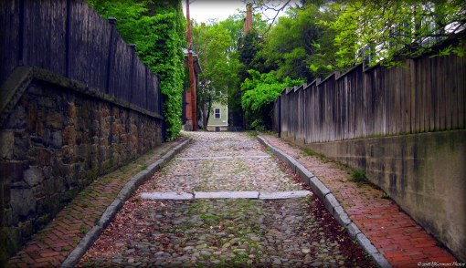
Cobblestones of Yesteryear at Neighbors Lane
Turning left on John Street you will start to look for another narrow right of way on the right called Neighbors Lane. The cobblestone street, last refurbished in 1998, showcases what all the roads in the area once looked like. Neighbors Lane has avoided asphalt over the years and remains one of the only streets in the city to remain cobblestone. The first house on the left is the Lippett Greene House and was built between 1803 and 1812. The house was once owned by Governor (and then Senator) Theodore Francis Green. The state airport is named for the former Governor. Turning left onto Williams Street, you will pass two brick houses on the left. Start looking for the next alley way on the right. It is after house #88 and is wedged between two stone walls. There is no street sign for the alley named Copley Lane. This alley is stamped asphalt and leads you to Power Street.
You have now reached Brown University. Before turning left onto to Power Street, take a quick glance to the right. Just a few feet away are the residential towers of the Brown University Graduate Center. The brick towers, four in total, connected by a common building, were built in 1968. After turning left onto Power Street, and passing a long brick wall, you will soon come to the house of the President of Brown University on the left. The house, built in 1922, is fronted by a wrought iron fence and gate. Continuing along Power Street and on the left you will catch a glimpse of the Nightingale-Brown House, a Georgian-style mansion built in 1792. It was purchased by the Brown family in 1814. Next, the large house on the right just before Benefit Street was the first mansion built in Providence and its first owner, John Brown, was a local merchant and politician. The John Brown House was built in 1786 and was visited by George Washington. Today the house is a museum run by the Rhode Island Historical Society.

John Brown House
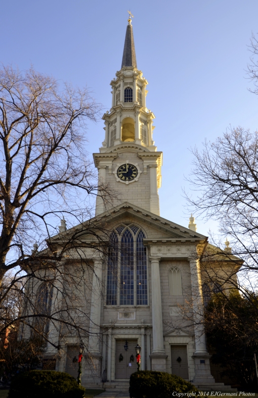
Turning right onto Benefit Street, you will follow it for a few blocks. Benefit Street, complete with old fashioned style streetlamps, has the largest concentration of colonial era houses, meticulously preserved, anywhere in the United States. Almost every structure along Benefit Street has its own history. For this walk you will follow Benefit Street for a quarter of a mile. After passing several historical homes you will come to the First Unitarian Church. This large white stone building was built in 1816 and in its steeple is a bell cast by the Paul Revere Foundry. The spire reaches 189 feet into the Providence skyline.
Continuing ahead, on the left at the corner of Hopkins Street, is the Stephen Hopkins House, built in 1707. Stephen Hopkins was the Governor of Rhode Island in four separate terms from 1755 to 1768. He also served as the Chief Justice of the Rhode Island Supreme Court. He is most famous for being a signer of the Declaration of Independence. George Washington quartered here at this house in the days before the American Revolution.
Continuing along Benefit Street and on the left, you soon come to the massive brick building of the Rhode Island Superior and Supreme Court House. This building was built between 1924 and 1933 into the steep hill between Benefit Street and South Main Street. The main entrance on Benefit Street is actually on the fifth floor of the building. To the right and just ahead is the Providence Athenaeum. This building, built in 1753, houses one of the countries oldest libraries. Edgar Allan Poe would frequent this library quite often during his days in Providence.
First Unitarian Church
Turning right onto College Street begins the half mile climb up Prospect Hill (also known as College Hill). Most of this section of the walk goes by buildings owned either by Brown University or the Rhode Island School of Design. Near the top of College Street on the left is the List Art Center. The building, built in 1971, stands on the ground where H.P. Lovecraft’s final home was. That house was moved to Prospect Street and will be passed later on this walk. On the right the Rockefeller Library built in 1965. This building, known as “The Rock” is Brown University’s library for social sciences and fine arts. On the left at the corner of Prospect Street is the John Hay Library. This building served as the university’s main library from its opening in 1910 until 1964. Straight ahead are the famed Van Wickle Gates at the main entrance of Brown University. These gates are only opened twice a year, once to welcome new students, and again at graduation for departing students. Behind the gates is University Hall, the oldest building of the university which opened in 1770.
Turning left onto Prospect Street, you will pass the main entrance of the John Hay Library. Just after the library is a memorial to H.P. Lovecraft, a Providence born horror fiction writer that spent most of his days in the area. Many of the buildings in the area are referenced in several of his books. Just before coming to Waterman Street and on the right is a 95 foot high brick clock tower. The Carrie Tower was built as a memorial in 1904 as a gift from the Italian husband who married the granddaughter of Nicholas Brown. After crossing Waterman Street, on the right is Robinson Hall. This brick building was built as a library in 1878 and now houses the Department of Economics for Brown University. Just ahead, about where Fones Alley crosses Prospect Street, two structures you can not see intersect below ground. The East Side tunnels, one for trains that was built in 1908 and is abandoned, and the other for trolleys built in 1914 and is still used by buses cross in this general vicinity. Just after Fones Alley on the right is another large brick residence. This house was built by George Corliss, the inventor of the Corliss Steam Engine.
Continuing ahead on Prospect Street, as you approach Meeting Street, there is the Woods Gerry House on the left. This large brick building now serves as the admissions office for the Rhode Island School of Design. To the right is the Mumford House. This was the last house that H.P. Lovecraft lived in when it was located on College Street. Across the intersection on the right is the First Church of Christ, Scientist. This building was built in 1913. The site the church sits on is one of the highest points in Providence. This hill was used as a warning beacon during the American Revolution. It is said that the beacon could be seen as far away as Cambridge, Massachusetts. Continuing straight on Prospect Street for the next two blocks you will pass several houses flanked by wrought iron and white picket fences.

Carrie Tower, Brown University
At the intersection of Prospect and Bowen Streets is the house of the President of the Rhode Island School of Design. The house is surrounded by a brick wall with a white fence on it. You have also climbed (and over) the second hill of this walk. Turning left onto Bowen Street, you will start your descent down Prospect Hill for a block coming to Congdon Street. Cross the street into Prospect Terrace Park and follow the walking path to the statue of Roger Williams. The sweeping view of downtown from this vantage point is quite impressive. From here follow the walking path back out to Congdon Street, turn right, and continue downhill passing a couple of older homes. You will want to turn right onto South Court Street. But first look ahead and to the left and you will catch a glimpse of the Congdon Street Baptist Church. Follow South Court Street one block to a small city park on the right. Note the sign commemorating Sissieretta Jones, an opera singer from Providence. She had resided in the area. Continue down South Court Street one more block down hill to Benefit Street once again. Across the street to the left a block away is the very distinctive looking armory of the Providence Marine Corps of Artillery, built in 1840.
Turning right onto Benefit Street, walk one block to North Court Street. Take a moment to pause here before turning down North Court Street. Ahead two houses on the right is the “Shunned House“. This was a story written by H.P. Lovecraft and this house, built in 1763, was the basis of the story. It is rumored that the house is haunted. The building just in front of you on the left is the old courthouse, built in 1863 and originally as a rectory for St. John’s Church. Today it is a bed and breakfast. Turn left and follow North Court Street for a little over a hundred feet and then turn left onto a walkway that leads to the front stairs of the large brick building on your left. This building, built in 1762, is possibly one of America’s most significantly overlooked historical sites. This is the Old Rhode Island State House and here on May 4, 1776 Rhode Island became the first colony to declare its independence from Great Britain, a full two months before the Declaration of Independence was signed. Walking down the tree lined walkway towards North Main Street, take a peek to your right. You will see a house set back from the road. This is the Benjamin Cushing House, built in 1737, is the oldest standing house on College Hill. Continue down the walkway, down the stairs, and then cross North Main Street at the crosswalk.

Old Rhode Island State House
After crossing North Main Street continue straight into the Roger Williams National Memorial. This park is maintained by the National Park Service and offers several kiosks with the history of early Providence, particularly during its settlement. Follow the parks path northerly toward the limestone and iron fence courtyard. Here in the courtyard is an octagonal shaped structure. This is the spring that Providence was founded around in 1636 by Roger Williams. Climb up the stairs and through the gate to the sidewalk. There is also a commemorative stone here indicating that this is where Providence was founded. Also across the street above the second floor windows of the stone building with a wrought iron fence is a plaque indicating that this was the location of Roger Williams house. From here continue northerly along the sidewalk toward the Visitors Center of the park. Due note along the way of St. Johns Episcopal Church across the street. The church, built in 1810, and its adjoining cemetery are on the National Register of Historical Places. Ahead, at the intersection of North Main Street and Smith Street is the Visitor Center. The building, the Antram-Gray House, is the oldest commercial building in the city, built around 1730. It was once a distillery and a general store. Now it is home to Rhode Islands National Memorial. The park rangers here are more than happy to assist you with any questions and there are restrooms here if needed.
From the Visitor Center, turn left onto Smith Street and follow the sidewalk (and the green line of the Independence Trail) to Canal Street. On the left just before Canal Street is a stone indicating the site of the Snow Town Riots in 1831. The race riot left four dead and led directly to the incorporation of Providence, which followed with the formation of a police force. At Canal Street be sure to use the crosswalks here at this very busy intersection. After crossing the intersection continue up Smith Street. This will begin the trek up the third hill of this walk. You will first cross the Moshassuck River, which in the 1830’s served as part of the Blackstone Canal, a shipping route between Providence and Worcester, Massachusetts. Moshassuck means “where the moose drinks”. Continuing uphill and to the left is one of several new buildings being built in downtown. This structure will be a 169 unit apartment building known as the Commons at Providence Station. It is one of several structures in Providences recent building boom. Next you will cross over the tracks of Amtrak’s Northeast Corridor. The Acela and MBTA trains come through here very frequently.
After crossing Gaspee Street and continuing up Smith Street for a few hundred feet, you will come to the Rhode Island State House. This building, built between 1895 and 1904, is made of 15 million Georgian white marble bricks and sits atop Smith Hill. It is the worlds fourth largest unsupported dome. Atop the dome is an 11 foot statue known as the Independent Man. The interior of the building is just as impressive and should be explored if you have a little extra time. For this walk, approach the entrance of the building and then stay to the left circling around the east terrace of the building. Be sure to look for the cornerstone at the northeasterly corner of the building. It is dated (in Roman numerals) October 15, 1896. When you reach the south side of the State House you get a rather impressive view of downtown ahead of you from atop of the stairs. The building immediately to the right with the columns is the Renaissance Hotel. It was originally built as a Masonic Temple in the 1920’s, but construction ceased and the work was never completed for over 75 years until it was finished as a hotel. Looking in the direction of the hotel and below on the State House west lawn is the Afghan/Iraq Memorial dedicated to local soldiers who gave their lives fighting the War on Terror. Looking over the east lawn you will catch a glimpse of Providence Station. This railroad station was built in the 1980’s when the railroad tracks were relocated further north. From here walk down the stairs and follow the tree lined path to Francis Street.

The Rhode Island State House
From here (still following the green line of the Independence Trail), cross the intersection and follow Francis Street to the south. The large building you are in front of is the Providence Place Mall, opened in 1999. The mall sits on property that was once the State Prison. In 1845, an innocent man was hung here at the prison, leading to Rhode Island banning capital punishment in the 1850’s. Across the street is Station Park. The large open field is used for events throughout the year including the Gloria Gemma Flames of Hope event every September. Ahead at the traffic light, you will want to cross Francis Street. A few feet along Finance Way follow the set of stairs that lead down to Waterplace Park. At the end of the stairs continue ahead passing the first pedestrian bridge and make your way to the amphitheater.
You are now at the heart of Waterplace Park, the centerpiece of the so-called 1990’s Providence Renaissance. This is the Woonasquatucket River, and it is still tidal here. The Native American meaning is “where the salt water ends”. Waterplace Park was completed in 1994 and Waterfire, an event where the “river is lit on fire”, has happened ever since. This area in years past was part of the Great Salt Cove, a large body of water north of Weybosset Neck. Over the years the cove was filled in. From this vantage point you see several of downtown’s iconic buildings. Looking to the building behind you with the clock and following the skyscrapers clockwise are the Blue Cross/Blue Shield Building (2009), Waterplace 2 (2008), Waterplace 1 (2008), One Financial Plaza (1973), 50 Kennedy Plaza (1985), Industrial National Building, a.k.a “Superman Building” (1927), Biltmore Hotel (1922), The Residences Providence (2007), and the G-Tech Building (2006). From the amphitheater, continue to follow the rivers edge to the next pedestrian bridge. Go up the stairs, cross the river and then turn right following the ramp down to a tunnel on the left. Turn into the tunnel. Currently at this location is the Wall of Hope, a 9/11 memorial made of 12,000 tiles painted by school children in the days after the September 11th attacks.
After passing under Memorial Boulevard you will approach the old Union Station. In fact this is the second structure built on this site. The first railroad station here was built in 1847 and was destroyed by fire in 1896. The new station, the current building, was opened in 1898 and served Providence until the current Providence Station opened in the 1980’s. Ironically, this building also suffered heavy damage from a fire in 1987 while being renovated. As you approach the building stay to the left and you will see an entrance to another tunnel that leads you under the old station, under Exchange Place and out to the skating rink at Kennedy Plaza. This rink is used for ice skating in the winter months and events such as roller derby in the summer months. Continue to follow the walk to Washington Street and the heart of Kennedy Plaza.
From here turn right following Washington Street, crossing Dorrance Street to the Biltmore Hotel. This hotel has been a staple of the Providence skyline for nearly a hundred years. It’s ballroom and famed glass elevator offer spectacular views of the city. From here cross Washington Street and you are in front of Providence City Hall. The building was built in 1878 of Westerly granite and its front steps offer a substantial amount of history in themselves. The steps served as the stage for speeches given by President Theodore Roosevelt and then presidential candidate John F. Kennedy.

Providence City Hall
Directly across the street from City Hall is Kennedy Plaza. This is the cities transportation hub where just about every public bus route in Rhode Island begins or ends. Within the plaza are a few monuments including the Soldiers and Sailors Memorial of the Civil War. The memorial, 11 feet in height, was erected in 1871 and pays tribute to the 1,727 Rhode Islanders who gave their lives fighting the war. Continuing from City Hall steps continue along Dorrance Street crossing Fulton Street. You are now entering into the heart of the downtown with its many small shops and stores. At the next block you will want to turn left onto Westminster Street. But first take a look up and down Westminster Street. Long before malls, Rhode Islanders would flock to this street to shop. For a short time this road was closed to traffic and used only for walking. Also note, the large 12 story building at the eastern corner of the intersection. Currently “The Dorrance“, this is the Federal Reserve Building, built in 1901. Above its main doorway is a carving of Roger Williams and Cannonicus (Native American Sachem). It was sculpted by Daniel Chester French who also sculpted the Lincoln Memorial in Washington D.C. Also of note is a marker at the corner of the building showing the height of the floodwaters during the Hurricane of 1938.
Turning left (east) onto Westminster Street will lead you into the center of the Financial District. First you will pass, on the left, the backside of the Peoples Saving Bank Building, built in 1948. The next building is the famed Industrial National Trust (“Superman”) Building, built in 1927. This structure, at 428 feet high and 26 stories, is the tallest building in Rhode Island. Its exterior is Indiana Limestone with Deer Island Granite at its base. A top the building is a peregrine falcon nest box. It is quite common to see the falcons soaring above the Providence skyline on any given day. Across the street from the “Superman Building” is the historical, and recently renovated, Arcade Building. Showcasing its Greek Revival architecture, this was America’s first enclosed shopping mall, built in 1828 complete with a 200 foot glass roof. Today there are several small shops including New Harvest Coffee, Split Apart Secondhand (a vintage clothing shop), and Livi’s Pockets (a Middle Eastern restaurant) among several others. The upper floors of the old mall are now micro-lofts. Back on the left, the next building is the 20 story 50 Kennedy Plaza Building. The reflective glass and granite structure was built in 1985. Lastly before the next intersection, on the left is the Exchange Building with its famed clock. The building is currently being considered to be renovated into a hotel.
You have now reached Financial Plaza and the fourth hill of this walk. Weybosset Hill is obviously no longer and was leveled while downtown was being built. This intersection, in the early days of Providence, led to the only bridge crossing the river at the time. It was at the end of a long neck of land and was also the end of a Native American route known as the Pequot Trail. Staying to the right at the intersection will bring you around the front of a curved building. Look up! This is the Turks Head Building. Built in 1913, the V-shaped building features a sculpture of an Ottoman Warrior looking down upon Financial Plaza. The original figurehead was from a ship named The Sultan. A shopkeeper at this location managed to obtain the figurehead and hung it above the entrance of the shop. It became a landmark. When the existing building was built, a sculpture of the Turks Head was added. The original wooden figurehead has been lost. Continuing around the corner to a crosswalk (now on Weybosset Street), cross the street. Looking up Weybosset Street you will see a three story building with the large flag pole. This is the Custom House, built in 1855, was used to monitor ships in the harbor and the wharf when the ships sailed directly into the city. There is a large glass dome at the top of the building the custom agents would use. Directly in front of you is the Amica Building. Due note the two markers on the building. These show the height of the floodwaters from the hurricanes in 1938 and 1954. Turning left you will come to the steps of the 23 story Textron Building built in 1972. Using the crosswalk to cross the street, you are now in front of the towering One Financial Plaza built in 1973. This is the second tallest building in the city and has 30 stories of offices. The building to the right of it is the 1917 Rhode Island Hospital Trust Building now owned by the Rhode Island School of Design. Staying to the left and passing a fountain you will next want to turn right onto Exchange Street.

The Turks Head
Continuing one block along Exchange Street you will come back to Kennedy Plaza. On the right, after crossing Fulton Street once again, is the Federal Courthouse. Note on the side of the building is a plaque commemorating the location that Abraham Lincoln gave a speech in 1860. The Federal Courthouse was built in 1908 and has been the home of some of Rhode Islands most infamous trials including the local mob and the former Providence mayor Vincent Cianci. Directly across from the front stairs of the courthouse in Kennedy Plaza is another monument of note. “The Hiker” is a statue that recognizes the service of the men who fought in the Spanish American War and The Boxer Rebellion at the turn of the 20th century. Continuing along Exchange Street and crossing Washington Street you will come to the Post Office Building. Built in 1939 as an annex to the Federal Courthouse using funds from the Works Progress Administration. Across the street from the Post Office is a statue of General Ambrose Burnside who fought in the American Civil War. The general, a Rhode Island Native, would later become governor and then a senator. The city park is named after him. Continuing ahead you will come to Steeple Street. Looking up Exchange Street you can see the State House once again perched up on Smith Hill. Here at the intersection is another building being added to the ever-changing skyline. This building is going to be an 8 story, 120 room extended stay hotel.
Turning right onto Steeple Street you soon come to Memorial Boulevard. This is a very busy thoroughfare, be sure to use the crosswalk here. After crossing the street you will cross the Woonasquatucket River. To your left is the Citizens Bank Tower built in 1990. Its unique location offers employees of the building views down the river. To your right is a set of stairs that leads to a small park. Here the three rivers of Providence converge, the Woonasquatucket on you right, and the Moshassuck on your left meet to form the Providence River. There are markings on the wall indicating historic flood elevations compared to regular tides. Making your way back to Steeple Street, turn right to cross the Moshassuck River, then turn right onto the brick walkway the street. The brick building to your left is the Washington Trust Building. The bank, founded in Westerly in 1800, is the oldest continuing community bank in the country. When you reach Washington Street you will use the crosswalk to cross the street. On the right where the bridge crosses the river once stood the World War Memorial in the middle of a large rotary.
Turn left now on Washington Street following the sidewalk to North Main Street. Ahead of you is the Trolley Tunnel that is used by public buses only. To the left you will see the First Baptist Church in America founded by Roger Williams in 1638. The current church was built in 1775 by Boston shipbuilders out of work due to the British Naval Blockade of Boston Harbor. Turning right onto North Main Street you will find yourself passing several buildings owned by the Rhode Island School of Design including the Illustration Studies building, the bookstore, the auditorium all on the right, and the world famous Museum of Art on the left. Across from the Museum of Art is the Old Market House and Market Square. The Market House, built in 1775, has a plaque on the front of the building depicting that this was the meeting place of the colonists who take part in Providences version of the Boston Tea Party. The building was also the home of the first Masonic Temple in Rhode Island having a third floor added to the original two story building in 1797. Walking around the left side of the building toward the back you will find another pair of plaques showing the flood levels of the hurricanes of 1815 and 1938.
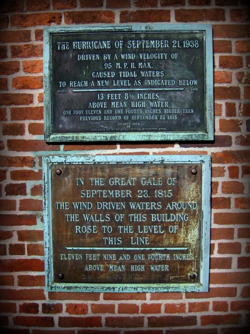
Hurricane Plaques at the Old Market House.
From here use the crosswalk to cross College Street and make your way into Memorial Park. The first monument of note is the Korean War Memorial with its soldier kneeling. Staying to the left you will next see the towering World War One Memorial. It was dedicated in 1929 and was located where the Washington Street bridge is until 1996 when it was moved to this park. From here, circle your way around the monument and towards the river. To the left is The Rhode Island Holocaust Memorial. From here, make your way to the sidewalk along South Main Street. Here is a unique artwork known as the Gun Totem. Looking across the street is the Superior Court Building once again. Continue down the sidewalk until you come to a fountain. Across the street is another Providence landmark, the gold domed Old Stone Bank building, built in 1854. The very colonial era building to its left is the Providence Bank Building. 121 South Main, is the 11 story building in front of you. It was built in 1984 and acquired by Brown University in 2005. At the fountain turn right back into the park and then right again to get to the World War Two Memorial. The names of all the Rhode Islanders who gave their lives are carved into the walls of the memorial. From here follow the path back toward the fountain, turn right and follow the path to the stairs up to South Water Street and the Crawford Street Bridge. This bridge once extended over a thousand feet upstream covering most of the river. It was listed in the Guinness Book of World Records as the worlds widest bridge prior to the reconstruction of the river in the 1990’s.
Use the crosswalk to cross the street and follow the sidewalk along the river. Along the way there are several informational signs about the docks and history of yesteryear as well as some sculptures. There are sections of the walk that are brick indicating where the former gangways were when this stretch was a booming seaport. You will see a row of older buildings sitting beyond a parking lot across the street. These are the historic Plantation Buildings and are now owned by the Rhode Island School of Design. One of the most renowned tenants is the Wild Colonial Tavern. Continuing along the Greenway and South Water Street, you will come upon the location of the Providence Flea, an event that takes place on Sundays from June to October featuring local vendors and musicians. Next is the land of the former Interstate 195. In the early 2000’s the interstate was moved south of the Hurricane Barrier and this land became vacant. On the right a pedestrian bridge is under construction on the piers of the former highway bridge. The lots across the street on the left have been used the last couple years for an artistic project known as 10,000 Suns. Eventually, all of the former 195 land on both sides of the river will be developed. Across the river is the former power plant of Narragansett Electric built in stages between 1912 and 1952. The building was decommissioned in 1995 and sat vacant until recently. It is now a nursing education center.
For the last leg of this walk you will approach the Point Street Bridge, a steel swing bridge built by Boston Bridge Works in 1927. It is the third bridge to span the river at this location. From here cross Point Street at the crosswalk. The large brick building in front of you is Corliss Landing. It has retail and offices on the first floor and residential lofts on the upper floors. After crossing Point Street turn right and cross Bridge Street, then turn left and follow the sidewalk down Bridge Street, you will come upon some of Providences waterfront nightclubs. The Whiskey Republic and The Hot Club both offer decks for outdoor libations and food. Even these buildings have history. The windows of the Hot Club were originally from Hope High School. When the school was being remodeled the windows were salvaged and re-purposed here at the local watering hole. The Hot Club also hosts the Good Night Lights every evening at 8:30. At the marina between the Hot Club and Whiskey Republic is the Providence River Boat Company, a company that offers tours of Providence from the river. Continuing just ahead this walk concludes at Mile End Cove where it started.
Though this walk, 5 and half miles in length, covers quite a bit of the city, it just scratches the surface. Providence is unique and offers an almost endless amount of history, architecture, art, and culture. Almost each and every building, house, and street has its own story.

Downtown From The Riverwalk
This walk is dedicated to Tom Bates, a man who loved Providence.
(June 3, 1943 – August 18, 2017)

Route of the Providence Historic Walk