Posts Tagged ‘ Fields ’

Caroline E. Judson – Smithfield

  • Caroline E. Judson Trust Property
  • Williams Road, Smithfield, RI
  • Trailhead:  41°54’34.26″N, 71°33’24.73″W
  • Last Time Hiked: January 15, 2018
  • Approximate distance hiked: 1.5 miles
  • Fairly easy with some significant elevation.


At the end of Williams Road is a small parking area for a couple of cars. The trail head is just to the right of the Land Trust sign. The trail winds downhill flanked by stone walls and old barbed wire fencing. Along this strip of wooded land on each side are large fields. At the end of the trail you can catch a glimpse of Stillwater Reservoir through the woods. The trail to the right leads into one of the large fields before dead ending near the property line with Hebert Health Center. The field is a good spot to watch birds circling above. The trail to the left leads further into the woods slowly winding down to a wooden bridge that crosses a beautiful cascading stream. The stream at the time of this hike was particularly high in velocity due to a recent snow melt. The trail then continues, following above the stream, into the Connors Farm Conservation Area at the blue blazed trail. A loop through Connors Farm, itself a beautiful hike, would add distance to the hike. From here retrace your steps back to the parking area at the end of Williams Road. A deer was spotted here at the property as well as chipmunks and a pair of red tailed hawks.

TWRI-CEJTP

Cascading Stream From the Footbridge.

Cote Preserve – North Stonington


Opened in September of 2017, the Samuel Cote Preserve is one of the newest trail systems in the area. The preserve is rather small and offers a great view of Spalding Pond. The entrance is along Clarks Falls Road and the parking area is a few hundred feet along a laneway on the left. From the parking area follow the laneway passing a large corn field on the right. Soon is a sign on the left for the trailhead. The blue blazed trail winds through the woods passing a massive white pine along the way. The trail comes to an old cart path called River Road. At each end of the road is private property. Please respect that and stay on the marked trail system. Turn right onto the cart path and follow it along Spalding Pond. There are several spur trails that lead to a trail that runs right along the shore. Back on the cart path you will see a sign for Trail 2, still blazed blue. Follow this trail back to the laneway and turn right. This will lead you back to the parking area.


Map can be found at: Cote Preserve.

TWRI-Cote

Blue Trail Along Spalding Pond

Richardson Preserve – Attleboro

  • Deborah and Roger Richardson Nature Preserve
  • Wilmarth Street, Attleboro, MA
  • Trailhead: 41°55’21.41″N, 71°14’7.69″W
  • First Time Hiked: October 27, 2017
  • Last Time Hiked: June 22, 2018
  • Approximate distance hiked: 1.0 miles
  • Fairly easy.


At the small parking area off of Wilmarth Road,  there is an old eighteenth century home upon a small hill with a large outcrop of ledge to the front left of the house. A new and welcoming sign for the preserve is just behind the house. Trails here are newly marked offering the blue blazed and main loop trail named the Charlie Wyman Trail. There is also a red blazed Vernal Pool spur trail. The trails pass through fields, forests, and swamps here The fields, being utilized as meadows to attract various insects and butterflies are fairly large and surrounded by a canvass of tall trees. There is a large assortment of trees on the property including maples, pines, oaks, holly, and sassafras to name a few. Two new boardwalks have been built here crossing part of Chartley Brook and a red maple swamp. This trail circles back toward the house back to area that has gardens that offer peony, milkweed, day lilies, and Siberian iris. The entire trail system is just about a mile.

TWRI-Richardson

Fall Field at Richardson Preserve

Lincoln Greenway – Lincoln


The Lincoln Greenway connects three town properties, Chase Farm, Lonsdale Park, and Gateway Park. The blazing system of red squares (to Gateway Park), yellow triangles (to Chase Farm), and green circles (to Lonsdale Park) is simple to follow. For this hike, led for the Blackstone Heritage Corridor, we started at Gateway Park by the historic Arnold House. After a short loop within Gateway Park on the paved paths we made our way to the northwestern corner of the park to the yellow blazed trail that leads up a steep hill. The trail soon comes to a residential neighborhood where we crossed a street. From here we continued along the trail on the opposite side of the road. The Greenway now enters into Lonsdale Park which is a wooded area behind the Lonsdale School. Continuing to follow the yellow blazes we soon came out the open fields of Chase Farm. We turned to the left and follow the perimeter of the farm following a grass mowed path. It soon came to a pond which we made our way around before turning to the left and then right following the perimeter of a large field once again. Soon we were back at the trail that leads back into Lonsdale Park. From here we retraced our steps back to Gateway Park this time following the red blazes.

TWRI-LG001

Along The Lincoln Greenway

Bradford Preserve – Westerly


A hidden treasure along Route 91 in Westerly. I have driven by the sign several times and glanced across the athletic fields. What I never knew (until I did a little research) is that there is a great hiking trail here. The trail is in fact a cross country trail for the Westerly High School but open to the public when not in use by them. The trail is blazed orange, but at the time of the hike, the blazes were a little faint. Just be sure to keep an eye for them at turns and intersections. The access the trail head from the parking area you must cross the large grass field to the right. You will find the trail head at the back end of the field. A short entrance trail will be the first part of the hike. Turn left at the intersection to do the orange blazed loop. The trail climbs slowly and steadily uphill for a bit passing stone walls, a vernal pool, and a fern covered forest first heading northerly before turning to the south. Ahead a trail to the left will lead you into the Woody Hill Management Area. Continue to the right here and continue to follow the blazes. When you reach the southern end of the loop you will come upon a large open field filled with tall grass and wildflowers. A path to the left will lead you back into the woods. Turn right here and follow the path along the edge of the woods keeping the field to your left. Take your time here and enjoy the sights. At the time of this hike the field had a variety of butterflies and the sounds of crickets. But the dragonflies stole the show, literally hundreds of them buzzing around. Soon the field path enters back into the woods and the trail starts its long descent downhill. Keep an eye out for a spur trail to the left. This trail leads you to a monument in the woods built in 1886 in honor of the Vars family who first came to the colonies in 1680. After stopping by the monument continue along the orange blazed trail, still descending, to the entrance trail. Here you will want to turn left and cross the field once again to the parking area.


Trail map can be found at: Bradford Preserve.

TWRI-BradfordWest

Trail in the Bradford Preserve

Pic-Wil Nature Preserve- Barrington

  • Pic-Wil (Picerelli-Wilson) Nature Preserve
  • Barrington, RI
  • Trailhead: Undisclosed
  • Last Time Hiked: June 25, 2017
  • Approximate distance hiked: 0.8 miles
  • Easy.


Mr. Ray Marr of the Barrington Land Conservation Trust and an avid lover of purple martins gave a public tour today of this property in Barrington. The Pic-Wil Nature Preserve, named after the former land owners Picerelli and Wilson, became a Barrington Land Conservation Trust property in 1987. The property was once the home to a bottling factory known as Deep Rock Water Company. Today, the property has three large meadows,  a small forest and a salt marsh on the upper reaches of Narragansett Bay. This property is a haven for birds. In fact it is known for its purple martins as they nest and resort here in the late spring and into the summer. The purple martin is a type of swallow, and here at Pic-Wil they reside in one of several gourd rack nests. At the time of this hike there were 53 nesting purple martins and over 100 in total. There are several bird boxes here as well as there is an attempt to attract the Eastern Bluebird. House wrens, hawks, and ospreys were also spotted here. The property has been home to deer, coyote, fox, weasels, squirrels, chipmunks, and rabbits as well. The small network of trails here lead you through the fields, the forest, and into the salt marsh. There is an active bee hive here on the property as part of a local pollination project. From the property you can see the Conimicut Lighthouse and across the bay to Warwick, North Kingstown, and Prudence Island. The property is not open to the public except when guided tours are offered. The tours are usually posted on their website or Facebook page. For more information contact the Barrington Land Conservation Trust.

TWRI-PICWIL1

Summer Meadow (Note the gourd rack nest)

Middletown Southern Loop – Middletown

  • Middletown Southern Loop – Sakonnet Greenway
  • Wyatt Road, Middletown, RI
  • Trailhead: 41°31’18.65″N, 71°16’0.33″W
  • Last Time Hiked: April 2, 2017
  • Approximate distance hiked: 2.7 miles
  • Fairly easy.


Part of the Sakonnet Greenway Trails, the Middletown Southern Loop is the southern most of three loop trails of the Greenway. The well marked yellow blazed trail winds around the edges of large open fields and through areas of woods. It also follows the edge of the Wyatt Road Soccer Complex as well making its way through Newport Vineyards property. The loop trail, mostly grass paths, is flanked in several areas by thick brush, a haven for birds. The trail also crosses a couple streams and passes small ponds. The trail tends to be a little muddy after heavy rain but otherwise is very easy on the feet as it is well maintained.


Trail maps can be found at: Middletown Southern Loop

TWRI-Sak02

Along The Middletown Southern Loop.

South Farm Preserve – Charlestown


This property is made up of two farm fields and woodlands. There is a set of perimeter trails around each field and blazed trails in the woodlands at the southern end of the property. A loop around the property is just a little over a mile. The farms here were once used for diary and sheep. Now the fields are essentially sanctuaries for birds and butterflies. In the north field two structures dominate the landscape. An old sauna (the chimney looking structure) and the re-built sheep barn offer a glimpse into the properties past. There is also a historic cemetery on the grounds, that being of the Card family. Graves here date back to the late 1800’s.


Trail maps can be found at: South Farm Preserve

twri-sfarm

Sheep Barn at South Farm

Pasquiset Pond West – Charlestown

  • Pasquiset Pond – West
  • Narragansett Trail, Charlestown, RI
  • Trailhead: 41°24’42.67″N, 71°37’12.49″W
  • Last Time Hiked: November 19, 2016
  • Approximate distance hiked: 1.5 miles
  • Fairly easy with slight elevation.


The Pasquiset Pond Preserve in Charlestown has two separate trail systems. The trail that leads into the western part of the preserve is at the end of Narragansett Trail.  As a matter of fact, this was once part of the Narragansett Trail when it ran from Lantern Hill in Connecticut to Wordens Pond in South Kingstown. This road has no signage and has two houses at the end of it. There is a small spot for a vehicle to park in front of the wooden barrier at the very end of the drivable road. Be sure not to block the residences access to their homes. The trail that leads into the preserve is actually a continuation of Narragansett Trail. It is a wide footpath that weaves through the southern edge of the property winding over gentle hills. There are some nice stone walls along the way and a couple spur trails. A little over a half mile the trail splits. The trail to the left, a continuation of Narragansett Trail, eventually leaves the property and comes to a nearby farm. Stay to the right here and follow the trail to a remote large grassy field. If you are lucky you will catch a glimpse of wildlife. The field and nearby trees are a haven for birds. I noticed several at the time of this hike including blue jays, woodpeckers, cardinals, and chickadees. After spending a moment at the field retrace you steps back to the trail-head. The remainder of the trails at this preserve are off of Old Coach Road about a quarter mile away.


Trail maps can be found at: Pasquiset Pond

twri-pasw1

The Field At Pasquiset Pond

Casey Farm – North Kingstown

  • Casey Farm
  • Boston Neck Road, North Kingstown, RI
  • Trailhead: 41°30’43.45″N, 71°25’23.07″W
  • Last Time Hiked: September 24, 2016
  • Approximate distance hiked: 4.1 miles
  • Fairly easy with some elevation.

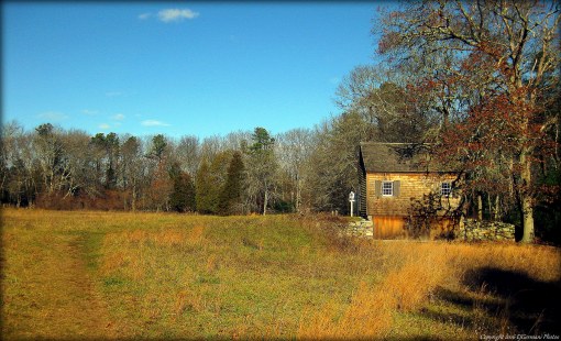
Most locals know Casey Farm for its farmer markets (one of the best in the state). Others know the farm for being a historical site. What a lot of people are not aware of is that Casey Farm offers miles of trails. For this hike, I joined a small group attending a Rhode Island Land Trust Days event. The hike was led by the very knowledgeable Dr. Bob Kenney of the University of Rhode Island. Mr. Kenney, (a walking encyclopedia of birds, mushrooms, and plants) volunteers quite often for the U.S. Fish and Wildlife Service and the Audubon Society. In fact this is not the first of his hikes I have been on. In 1659, several colonists bought the land on Boston Neck for a mere 18 cents per acre from the Narragansetts. One of these families were the Richardsons. By 1702 half of that property belonged to the family that founded Casey Farm. The farm stretched from Narragansett Bay to the Narrow River as it still does today. The property, a working farm, is protected and owned by Historic New England. Atop the hill along Boston Neck Road is where the farm is located. It consists of several fields and structures including a large barn as well as old New England style stone walls. The first part of the hike took us into the eastern part of the property down to Casey Point. The old cart path passes through areas of wildflowers including wild snapdragon, black swallowwort milkweed, and heart leaved aster. There is also an abundance of ferns, mushrooms, and an invasive shrub known as devils walking stick. This area is also a haven for birds as we saw and heard catbirds, woodpeckers, and red tailed hawks. When we reached the point we had sweeping views of the west passage of Narragansett Bay. Across the bay is Jamestown and the large open field is part of Watson Farm (another Historic New England property). Beyond Jamestown you will see the Newport Bridge. To the north is the Jamestown Bridge and Plum Point Lighthouse. To the south you can see Beavertail Light and Dutch Island Light. After spending a little time on the point we retraced our steps back to the farm. From here we then followed another stone walled flanked cart path toward the heavily wooded western end of the property. We briefly entered the neighboring King Preserve, the newest Nature Conservancy property in Rhode Island. This preserve is a work in progress still. Most of the major trails are complete and open, however, there are a section of trails yet to be built. The trails are soft and there are boardwalks that cross wet areas and streams. There is plenty of ferns in this area among the birch trees and sassafras. We nearly reached the Narrow River at the bottom of the hill before making our way back uphill along old cart paths and dirt roads winding through the Casey Farm property. This stretch of the hike also offer sounds and sights of nuthatches, tufted titmouses, and eastern towhees. We then returned to the farm to conclude the hike. Casey Farm is open from June 1st to October 15th on Tuesdays, Thursdays, and Saturdays. There are also tours of the farm available. For more information please call 401-295-1030.

A note from the folks at Casey Farm:  Casey Farm is open to the public during daylight hours for hiking trails at Casey Point or those adjacent to King Preserve. Please note dogs must be on leashes, clean up of course, and respect the young people and farm animals by keeping dogs away from the farmyard and fields. Access Casey’s woodland trails via the King Preserve. Camp Grosvenor is not open to the public for hiking. Access Casey Point on Narragansett Bay via the gate on Boston Neck Road. We are working on getting better signage. Feel free to contact me with any questions: Jane Hennedy, site manager, 401-295-1030 ext. 5, jhennedy@historicnewengland.org.

twri-casey04

Casey Point with The Newport Bridge in the distance.

twri-casey06

Flanked by Wildflowers