Quequechan River – Fall River
- Quequechan River Rail Trail
- Wordell Street, Fall River, MA
- Trailhead: 41°41’47.97″N, 71° 8’45.86″W
- Last Time Hiked: December 21, 2017
- Approximate distance hiked: 1.8 miles
- Easy.
The Quequechan River runs from South Watuppa Pond to the Taunton River and once had a series of eight waterfalls. Quequechan is a Wampanoag word meaning “falling water” in which the city received its name. Most of the river over the years has been built over or channeled for the massive mills that sprouted up along the river. Today a the river is the centerpiece of a former railroad bed that has been converted to a walking path/bike path. Starting from a parking area at the end of Wordell Street follow the paved path along the soccer field at Britland Park. Here you will find a informational kiosk showing the trails. Staying to the right I followed the main stretch of the trail down to Quequechan Street before turning around and retracing my steps. The trail passes over a series of wooden bridges and the river serves as a foreground of the historic mills. Once back to the kiosk, I opted to follow the paved path along between the soccer field and the river to its (currently) dead end and back. The map indicates that this may become a loop in the future. Once back to the kiosk again, I retraced my steps back to the parking area.
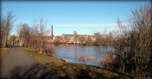
The Fall River Mills serve as the backdrop of this walking path.
