Archive for the ‘ ~CHARLESTOWN RI~ ’ Category

Tucker Woods Preserve – Charlestown

  • Tucker Woods Preserve
  • Alton Carolina Road, Charlestown, RI
  • Trailhead:  41°27’2.07″N, 71°40’16.74″W
  • Last Time Hiked: June 18, 2022
  • Approximate distance hiked: 1.2 miles
  • Fairly easy with slight elevation.

One of the newest trails opened to the public, Tucker Woods, once farmland, is now permanently protected by the Charlestown Conservation Commission. Starting from a new parking area along Alton Carolina Road follow the blue blazed trail into the property. The trail first passes by an open field with sporadic pitch pines before moving into the wooded area shaded by a canopy of oak. The trail widens to an old cart path. You will pass the yellow trail on the right. Continue ahead for now. The forest floor is covered in fern in some spots and there is a rather large hill on the left (future to top of hill is planned). You will pass the other end of the yellow trail, still continue ahead to the end of the blue trail. It splits and makes a loop. Continue ahead and uphill. The trail turns sharply to the right and follows a stone wall before turning again completing the loop. From here stay left and retrace your steps back to the yellow trail (now on your left). Turning onto the yellow trail, start looking for a spur on the left. This leads to a sitting area by a babbling brook with a small “waterfall”. The other side of the brook is part of the Carter Preserve. Making your way back to the yellow trail, turn left, and follow it to its end. The trail winds along the side of a hill for a bit before cutting its way back to the blue trail. At the blue trail turn left and retrace your steps back to the parking area. Trail map is at the kiosk and should be online in the future.

TWRI-Tucker05

Along The Yellow Trail

Sammy C North – Charlestown

  • Sammy C North
  • Shumankanuc Hill Road, Charlestown, RI
  • Trailhead:  41°24’33.33″N, 71°41’23.60″W
  • Last Time Hiked: November 20, 2020
  • Approximate distance hiked: 3.7 miles
  • Moderate, can be difficult in areas.


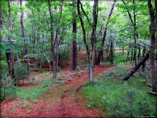
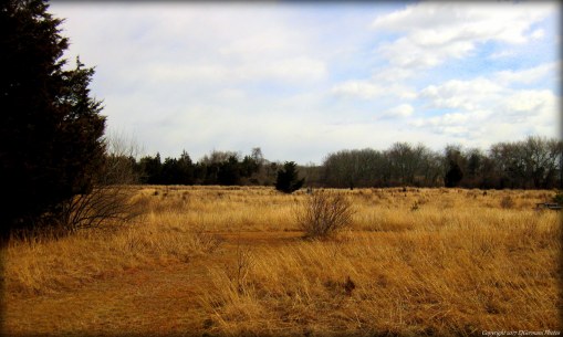
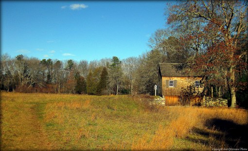
Six days prior I had done the Sammy C South loop. I had realized then that there was more to the Sammy C to be done. Today, with a map in hand that shows all of the trails, I headed out to explore the rest as well as the Secret Trail. Starting from the small parking area (big enough for two cars) along Shumankanuc Hill Road, follow the unmarked trail into the Management Area. Hunting is allowed here, be sure to wear orange! This trail is quite level and is flanked by small ledges giving you a preview of what lies ahead. You will reach a trail intersection. Make note of the area, you will need to leave the property here as well. Turn right here and follow the white blazes. You are now on the Sammy C Trail. It winds up and down and up and down several times over small hills and along ledges. There are some great stone walls along the way, one with an old gate opening marked by granite posts. Possibly an old farm? After climbing over several more small hills and weaving through their valleys the trail levels out a bit passing closely to Buckeye Brook Road before veering off to the left and slightly downhill. The Sammy C soon ends at the double white blazes. Here turn left onto the yellow blazed Vin Gormley Trail and follow it a bit crossing a stream first before coming to a trail intersection. At this intersection the yellow blazes turn to the right. Continue straight ahead onto an unmarked trail. This trail is fairly level. Start looking for a white/red double blaze on the left. This is the Secret Trail and it will give you a workout. Also be sure to follow the blazes as this trail turns often and suddenly in many locations as it traverses up and over several rock formations. Following the Secret Trail you will first encounter an upward climb followed by an area of trail that straddles a 20 foot plus ledge. There is no “guardrail” here so do use caution. Another highlight along this stretch is a towering sycamore tree in the valley below. The trail then comes out to a wider cart path. Turn right here, still following the blazes, and start looking for your next turn on the left. The next highlight is a large outcrop, the trail is to the right here slightly downhill. The trail now weaves through groves of mountain laurel and rock formations as it zigzags to the east. There is an area that can be a bit confusing ahead so be sure to follow the blazes. The trail descends in to a valley and quickly climbs up a rock outcrop. At the top the trail turns to the left and does an almost complete circle to the right before climbing up another rock. The blaze is beyond that rock. From here the trail descends into another valley, crosses a stream, and then climbs back up yet another significant hill before ending at the School House Pond Trail. Turning left here, follow the blue blazed trail as it descends down hill to the next trail intersection. Turn left, back onto the Sammy C Trail, blazed white, and follow it back to the trail you entered the Management Area on. Along the way you will come across a boardwalk, more mountain laurel, and another large outcrop. Note the indentation in the outcrop. It looks as if a hiker left their footprint here along their journey. When you reach the next intersection. Turn right. This will lead you back to the parking area.


Map can be found at: Sammy C North.

TWRI-SammieN07

The Sammy C Following an Outcrop Along A Stone Wall

Sammy C South – Charlestown


I went into this hike blindly assuming that the Sammy C Trail only ran from the Vin Gormley to the School House Pond Trail. I would learn later that was not true. I did have a plan and a route in mind (which I kept true to for this hike). This hikes starts along Kings Factory Road where the Vin Gormley skirts back into the woods just north of Quail Lane. There is street parking here for a handful of cars. There is also a “Mile 5.5” sign here. Following the yellow blazed Vin Gormley Trail, you will descend slightly until you get to Cool Spring Road. Here take a right and then an immediate left following the yellow blazes. Just after the road look for the sign for the Sammy C Trail on the right. The Sammy C Trail is used quite a bit by cyclists as it offers quite a bit of ups and downs. Following the white blazes the trail winds through glacial outcrops, thick ground covering, and a stream crossing before coming to the “NEMBA” bridge, a mountain bike obstacle. You will not miss it!! (NEMBA = New England Mountain Bike Association). The trail then zigzags up and over small ledges for a bit passing stone walls, a couple more boardwalks, and large areas of outcrops, before finally coming to the School House Pond Trail. This is where I thought the trail ended… but! The sign here indicated that the Sammy C continues north. With no information in hand I kept to the plan and decided the rest of the Sammy C would be done later after some research. So here I turned left and followed the blue blazed School House Pond Trail (toward the Vin Gormley) as it steadily, but gently climbed up hill for quite a distance. There is a nice grove of mountain laurel along this stretch. Soon I came to an intersection. To the right was the Secret Trail. Well that wasn’t on my map either. The next hike could prove to be interesting! Looking around I noticed the blue blazes uphill to the left. The trail now followed the edge of a ledge above a valley below to the right. The trail soon turns downhill, through the valley and back up the other side. The trail then continues passing a stone wall and crossing a stream before ending at the Vin Gormley Trail. Taking a left here, follow the yellow blazes. This trail will lead you back to the parking area, first passing through some interesting rock formations, and the by Cool Spring Road once again before ending at Kings Factory Road. Hunting is allowed here, be sure to wear orange!


Map can be found at: Sammy C South.

TWRI-SammieS03

NEMBA Bridge

TWRI-SammieS07

Along The Sammy C Trail

Ninigret Beach – Charlestown

  • Ninigret Beach (East Beach)
  • East Beach Road, Charlestown, RI
  • Trailhead:  41°20’37.88″N, 71°41’22.71″W
  • Last Time Hiked: February 15, 2020
  • Approximate distance hiked: 5.8 miles
  • Fairly easy beach walk.


The beach between Blue Shutters Beach and the Charlestown Breachway is part of East Beach State Park and the Ninigret National Wildlife Refuge. It is a long three mile strand of beach that is not overwhelmed with humans. In the summer a fee must be paid the access the beach and parking is very limited. In the winter the beach is desolate, especially at sunrise. This day was a windless but brutally cold February morning. Hike time temperature was a sweltering 7 degrees Fahrenheit. I came here armed with cameras to catch the sunrise, multiple layers of clothes, but mostly to find solitude to clear the mind. Success! I arrived at the small parking area before sunrise and made my way to the beach. To the east I could see the beacon of the Point Judith Light. To the south I could see the lights of Block Island twinkling. Along the horizon between them, the glows of pink, magenta, fuchsia, and orange setting the sky up for a spectacular sunrise. I turned to the east and followed the empty beach for a few miles. At 6:42 AM, just as scheduled, the piercing light of the sun broke the horizon. The beach suddenly a glow of of the colors in the sky. In the distance I could make out my destination, a dark shadow strip of the breachway stretching into the ocean. As the sun rose into the sky the beach came to life with sea birds. The waves broke gently and peacefully.  I spent only a few minutes at the breachway before retracing my steps back to the parking area. This walk is exactly what was needed. I did not run into a single soul! Also as a side-note, I was still cold when I ordered my breakfast sandwich at Sophie’s (in Exeter) a little while later.

TWRI-EastBeach01

Winter Sunrise

Patricia Sprague Forest – Charlestown

  • Patricia Sprague Forest Preserve
  • Railroad Avenue, Charlestown, RI
  • Trailhead:  41°27’4.63″N, 71°39’21.18″W
  • Last Time Hiked: February 2, 2020
  • Approximate distance hiked: 1.4 miles
  • Fairly easy, some elevation.


For a relatively short, but stunningly beautiful hike just off of Route 112 in Charlestown, the Patricia Sprague Forest offers quite a bit. Starting from a small parking area along Railroad Avenue, follow the blue blazed, pine needle covered trail into the property first passing a stone wall and glacial boulders before coming to a split. For this hike stay to the right following the blue blazes northeasterly along the properties southern border. Ahead, just off the trail and on the right, is an old fire pit that overlooks the valley below. Continuing along the blue blazed trail you will catch glimpses of the Pawcatuck River down below on the right. The trail then descends rapidly into a valley, then climbs back uphill, over a ridge-line and finally into an open field. At the field stay to the right following the fields perimeter on a beaten path that traverses the northern reaches of the property. You will pass through a very young pine grove along this stretch as well. The trail leaves the field for the last time as it bears right into the tall pines and along the properties western border. Ahead you will pass through an old orchard before coming to the entrance trail. Stay to the right here and retrace your steps by the stone wall and back to the parking area.


Map can be found at: Patricia Sprague Forest.

TWRI-PSpr02

Stone Walls and Tall Trees

Francis Carter West – Charlestown

  • Francis Carter Preserve – West
  • Kings Factory Road, Charlestown, RI
  • Trailhead:  41°25’56.37″N, 71°41’37.11″W
  • Last Time Hiked: March 10, 2018
  • Approximate distance hiked: 3.8 miles
  • Fairly easy.


The newest addition of the Francis Carter Preserve, being the western end, acquired in 2014 offers the red blazed Narragansett Loop and River Trail. This part of the preserve is a great example of how nature can reclaim land that was once industrial. This hike starts from the parking area along Kings Factory Road just south of the Pawcatuck River. The red blaze trail meanders east along the rivers edge first passing a fenced in cemetery. The trail soon comes to an area that is sandy and rutted by dirt bikes and ATV’s. Stay to the left here and you will find the next blaze. The aptly named river trail soon runs along the Pawcatuck River once again. The trail here climbs up and down small hills before ascending gently to a large open field. From here it is important to follow the signs. Turning left, follow the red blazed Narragansett Loop. Bear in mind that this a new trail and not as defined as other established trails in the preserve. In time the trail will be well used and well defined. For now keep an eye out for the next sign. The trail continues northward for a bit before turning to the right and joining with the Grassland Trail. Here you will want to stay to the right following what is now both the Narragansett Loop and Grassland Trail to the south. The path soon turns to the left following the southern perimeter of the large meadow. Just before the woods, on the left, there is an informational board about the grasslands. Take a moment to look at it. From here, continue straight into the woods following the yellow blazed trail. Just before the hill, the red blazed Narragansett Loop turns to the right into one of the nicest stretches of trail in Rhode Island. On the left you will find the ruins of on old chimney. The trail winds below a canopy of pines and hemlocks before passing under power lines. Continuing ahead the trail follows and old stone wall before turning to the left, slightly uphill, to some large boulders left behind from the last glacier. The trail soon comes to an old cart path where you turn right continuing to follow the red blazes. The pine trees here are very dense and thick making for a well shaded pine grove. The trail soon comes to a pair a gates. After passing the gate, you will be on a an old asphalt road. The signage here indicates that this section of the Loop Trail is temporary. The road soon comes to an intersection. The roads ahead and to the left are active. Turn right onto another abandoned asphalt road. This was the entrance road of the former industrial complex from yesteryear. The road soon bears to the left and becomes a dirt road. A few hundred feet ahead is the intersection where the River Trail comes to the Narragansett Loop. Turn left here and retrace your steps back to the parking area. Hunting is allowed on this property at times. Be sure to wear blaze orange during hunting season.


Map can be found at: Francis Carter West.

TWRI-CW07

Along The Narragansett Loop Trail

North Camp – Charlestown


Burlingame is most likely known for its campground off of Route 1. What most people do not know is that there is an abandoned camp on the north end of Watchaug Pond. Starting from a small parking area by a gate (two tenths of a mile east of the main parking area) on Buckeye Brook Road, you first follow an old dirt road southerly into the management area. You will soon come to an intersection. The trail that crosses is the 8 mile Vin Gormley Trail. For this hike continue straight ahead passing a couple small ledges and stone walls. The trail the splits at a fork, stay to the right for the first views of the former camps ruins. On the left you will see an old structure that is decaying rapidly. Continuing ahead you will soon come to another trail intersection. You will want to turn left here, but first follow the trail straight ahead for your first glimpse of Watchaug Pond. Returning to the last intersection, (trail now on your right), turn and follow the trail to the next intersection. The trail to the left would lead you back to the trail you came in on, the trail to the right will lead you to some more ruins if you care to check them out, the trail ahead is what you want to continue on. The trail slowly veers to the right and out to a small beach that overlooks the pond. At the opposite end of the beach the trail continues. Stay to the right, the trail winds to the left through an area that looks as if it were once campsites. The trail now bends to the north passing another building on the right before narrowing quite substantially and following a stone wall to the right. At the next trail intersection turn left onto the yellow blazed Vin Gormley Trail. In a few hundred feet you will come to the old dirt road you came in on. Turn right here and retrace you steps back to the parking area. Other than the Vin Gormley Trail, none of the trails on this hike are blazed.


Trail map can be found at: North Camp.

TWRI-NorthCamp

The Beach at North Camp

Pawaget Park – Charlestown


Once a driving range for practicing golfers is now a nice little pond side park just off the bustling Route 1. A half mile grass trail now winds through the area that was once the landing area for flying golf balls. Along the winding path are areas to picnic. The property also has a boardwalk and viewing deck that overlooks Ninigret Pond. A stone dust path back from the deck to the parking area makes for a shorter route back. The stone dust path, boardwalk, and deck are all ADA compliant.

twri-pawaget

Pawaget Park

South Farm Preserve – Charlestown


This property is made up of two farm fields and woodlands. There is a set of perimeter trails around each field and blazed trails in the woodlands at the southern end of the property. A loop around the property is just a little over a mile. The farms here were once used for diary and sheep. Now the fields are essentially sanctuaries for birds and butterflies. In the north field two structures dominate the landscape. An old sauna (the chimney looking structure) and the re-built sheep barn offer a glimpse into the properties past. There is also a historic cemetery on the grounds, that being of the Card family. Graves here date back to the late 1800’s.


Trail maps can be found at: South Farm Preserve

twri-sfarm

Sheep Barn at South Farm

Moraine Preserve – Charlestown

  • Moraine Preserve
  • Kings Factory Road, Charlestown, RI
  • Trailhead: 41°23’8.76″N, 71°39’58.90″W
  • Last Time Hiked: December 3, 2016
  • Approximate distance hiked: 1.9 miles
  • Moderate with some elevation.


A fellow hiker stumbled upon this aptly named preserve and today we decided to check it out. A moraine is defined as “a mass of rocks and sediment carried down and deposited by a glacier, typically as ridges at its edges or extremity”. During the last ice age, much of this area was defined by the glaciers. This preserves features resembles that of the Champlin Glacier Park and Duval Farm. And what a property it is!! There is a short loop trail (approximately 3/4 of a mile) in the front half of the property that is blazed blue. It winds, twists, and turns over small but steep ridges and the trails are flanked by groves of mountain laurel. At the time of this hike we stumbled upon the construction of the back loop. Technically open, the trail is in fact under construction and the features are the same of the loop trail up front. The trail is mark only by flagging at this time but will be blazed blue as well. Footing is a little rough so watch your step. There are some quite impressive views of Block Island through the trees atop the ridge that overlooks Route 1. A return visit in the spring will be necessary to see the new trail in its completed state.


Trail maps can be found at: Moraine Preserve

twri-cmoraine

Uphill Through Mountain Laurel