Mud Bottom Brook – West Greenwich
- Mud Bottom Brook – Big River Management Area
- New London Turnpike, West Greenwich, RI
- Trailhead: 41°37’4.38″N, 71°35’46.70″W
- Last Time Hiked: May 16, 2020
- Approximate distance hiked: 4.5 miles
- Moderate, navigation can be difficult.
First and foremost, I would advise not to attempt this hike without a map, GPS tracking, good sense of direction, or all of the above. I personally have ventured into Big River enough times to feel comfortable enough to wander its many, many, many trails. To say Big River has a vast network of trails is a gross understatement. For this hike I took a wrong turn along the way and found myself on a trail that was not on the Great Swamp Press map and found myself relying on GPS tracking and my internal compass to make my way back to a main trail. (My guest did a great job at remaining calm!!) With that being said, I am going to attempt to recall my route, but please don’t rely on this post alone if you attempt this hike. From the parking area at the end of New London Turnpike by the Wincheck Gun Club we passed the gate and followed the pine tree flanked dirt road for about four tenths of a mile. Turning left the trail then winds downhill to its end. Here we turned right onto a trail called Sweet Sawmill Road. This trail climbs slightly uphill passing some stone walls on the right. At the next intersection we turned left and followed that trail just under a half mile to its end. The trail widens at its end, stay to the right here. The trail then declines slightly into the valley that Mud Bottom Brook runs through. Along the way, after a heavy rain, you may encounter some large puddles along this trail. At the next intersection stay to the right and again right a little further down the trail. This trail will lead you to the crossing at Mud Bottom Brook. There is a wobbly plank and stones here to make the crossing easy. From here we continue ahead until we came to a “T” intersection. The trail in both directions at the time of this hike was blazed blue. The blazes are amateur and not by any means the type of blazes seen at Arcadia. We turned left here and still feeling confident we were on the right track and started to follow the blue blazes. At the next intersection is where I suspect the plan went out the window. We came to the intersection realizing it was not on the map. Thinking we might have been a little further north, I suspected the trail to the left might be the second crossing of Mud Bottom Brook. We turned right here thinking it would continue along the edges of the peninsula are eventually turn south paralleling the Carr River. It did not! (I do not actually know where the trail to left leads, that will be a hike for another day). After turning right we soon came to another intersection, again blue blazed. We turned right and followed it nearly a mile up and down hills, zigzagging back and forth to its end. This stretch was actually quite pretty. We passed stone walls, a rather large natural looking swale, and hunting stand along the way. At the intersection at the end of the trail blue blazes go to the right. Using the internal compass at this point we turned left and then almost immediately left again and then right just up ahead. The trail we were on would lead us back to the New London Turnpike trail. Turning right onto the sandy road it veers slightly to the right before curving to the left and straightening out. Ahead the sandy road splits again. Stay to the left here. This is the trail back to the parking area just under a mile away. The remainder of the walk climbs slightly uphill along the wide New London Turnpike. Be sure to wear orange here during hunting season.
Map can be found at: Mud Bottom Brook.
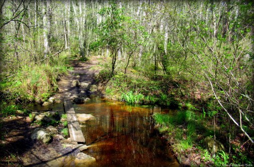
The Crossing At Mud Bottom Brook
