Archive for December, 2021

Goat Hill Lock – Uxbridge/Northbridge

  • Goat Hill Lock
  • Hartford Avenue East, Uxbridge, MA
  • Trailhead:  42° 5’50.94″N, 71°37’25.35″W
  • Last Time Hiked: December 21, 2021
  • Approximate distance hiked: 2.4 miles
  • Moderate, significant elevation.

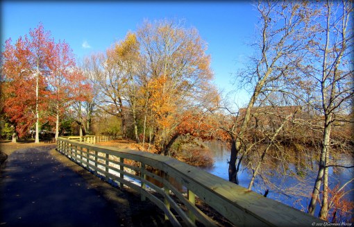
Goat Hill itself can get the blood flowing as some of the trail is quite steep. The trail that runs along the bottom of the hill along the river is much easier and fairly level. For this hike, I did a loop that included climbing up and over the hill making for a moderate hike. From a small parking area along the side and across the busy road, make your way across a large open lawn to the kiosk. Beyond the kiosk and a couple hundred feet into the woods look to turn left and start the climb up the hill. The trail is blazed blue and the ascent is steady. In the winter months you will have a view of the Blackstone River to the right. On the left you will start to notice boulders up upon the hill. Soon you will see an unmarked trail to the left. Ignore it and continue ahead following the blue blazed trail. The trail plateaus briefly. There are scattered boulders throughout this area. The trail the continues uphill and becomes increasingly steeper. There are a few more spur trails in this area. Some have signs such as “PK&C”, “Bone Spur”, and “Greenway”. There appears to be a significant trail system upon the hill, but they are not shown on the trail map. Explore at your own risk. For this hike continue to follow the blue blazes. The trail crests over the top of the hill and starts a steady descent flanked by an impressive stone wall on the left. Take your time a watch your footing here as the descent can be a bit difficult. At the bottom of the hill turn right and follow the blue blazes to the next intersection. Along this stretch is a seasonal babbling brook on the left for a bit. At the next intersection turn left and down a short but steep section of trail then continue ahead to a small wooden bridge. This is the Goat Hill Lock. It once was part of the 1828 Blackstone Canal. This is a good spot for a break. From here return to the last intersection and turn left. The trail is blazed blue, fairly level, and follows the foot of the hill back to the kiosk at the entrance. Along the way you will have views of the river on the left as well as Rice City Pond. To the right there will be areas of bull briar, a haven for songbirds, and a rather significant boulder. You should wear orange here as hunting is allowed.

Trail Map: Goat Hill Lock.

TWRI-GHL

Bridge at The Lock

Pierce Riverwalk – Central Falls

  • Pierce Riverwalk – Blackstone River Bikeway
  • High Street, Central Falls, RI
  • Trailhead:  41°53’40.95″N, 71°23’0.18″W
  • Last Time Hiked: November 19, 2021
  • Approximate distance hiked: 0.6 miles
  • Easy, paved bike path.

A new section of the Blackstone River Bikeway has arrived in Central Falls. The short three thirds of a mile path takes the existing route off of the streets of Central Falls and along the Blackstone River for a bit. It also reopens the long closed Pierce Riverwalk and Park. The path, from High Street to Cortland Street, offers views of the Blackstone River and sits on land once the home to a fierce battle between Native Americans and Colonists.

TWRI-PPR01

The Riverwalk Along The Blackstone River

Market Square – Woonsocket

  • Market Square – Blackstone River Bikeway
  • Market Square, Woonsocket, RI
  • Trailhead:  41°59’59.80″N, 71°31’1.79″W
  • Last Time Hiked: November 17, 2021
  • Approximate distance hiked: 1.2 miles
  • Easy, paved bike path.

A new section of the Blackstone River Bikeway has arrived in central Woonsocket. The short six tenths of a mile section is all off road from Market Square easterly crossing Main Street to Truman Drive where it crosses then follows the road northerly to its end. After crossing under Court Street you will catch glimpses of the Blackstone River through the trees. At the end turn around and retrace your steps for a 1.2 mile walk.

Trail Map: Market Square.

TWRI-MarketSq

Blackstone River Bikeway Along Truman Drive

Shaw Farm – Sutton

Shaw Farm has several fields at its northern end but the trails are in the central and southern wooded parts of the property. From the parking area stay left of the shed. Shortly ahead is another structure. Stay to the left of that building as well and then follow the edge of a large field keeping the tree line to the right. head is an opening in the tree line. Continue through the opening into another field. Again keep the tree line to the right passing the Center Trail to the right. Ahead, turn right onto the Challenge Trail. It enters the woods and descends quickly into a valley. Ahead is a stream crossing by a stone wall. This can be a bit challenging but manageable. The trail veers uphill and to the left a bit before coming to the Fallen Oak Trail. Stay left here and continue the long steady climb to the southern end of the property. You will pass through a ravine and cross a couple streams along the way. Turn left onto the Shaw Trail next. It will take you to the highest points of the property as it skirts Central Turnpike. Next turn left onto the Center Trail for a moment then turn right onto the Hunter Trail. The trail is a little narrower but is fairly level. Next turn right onto the Laurel Trail. The aptly named trail winds through a small grove of mountain laurel before coming out to a field. Turn right then left passing through the center of the field. Ahead the trail re-enters the woods. The trail to the left follows the edge of a pond then veers left to come to the backside of the barn. Passing the barn to the right brings you back to the parking area. This hike follows a perimeter route.

Trail Map: Shaw Farm.

TWRI-Shaw03

Stream and Stone Wall