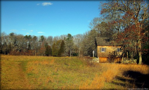
Archive for December, 2016

Sheep Farm – Groton


This interesting property features a loop red blazed trail, a yellow trail, and a blue trail that cuts through the property. Fort Hill Brook is the highlight of this hike with its series of waterfalls. There are also remains of old mill sites throughout the property. The property is covered with scattered boulders and there is an open field with bird boxes.


Trail maps can be found at: Sheep Farm

twri-sheep

Falls at Fort Hill Brook

Capron Park – Attleboro


Capron Park is mostly known for its zoo. The park area out in front of the zoo has a few walking paths and a loop road. Joggers and walkers are seen here quite often exercising. The park also has plenty of monuments, a gazebo, a bandstand, and a rose garden. The zoo is open year round.

twri-capron

Walkway and Gazebo

Balfour Riverwalk – Attleboro

  • Lloyd Balfour Riverwalk
  • North Main Street, Attleboro, MA
  • Trailhead: 41°56’43.60″N, 71°17’11.70″W
  • First Time Hiked: December 23, 2016
  • Last Time Hiked: November 17, 2018
  • Approximate distance hiked: 0.4 miles
  • Easy.

This small river front park by the Attleboro Library offers a short paved walking path. Within the downtown park is a skate park, playground, and a volleyball area. The walkways are flanked by several trees, monuments, and park lamps. The Ten Mile River passes the park.

twri-balfour

Balfour Riverwalk

South Farm Preserve – Charlestown


This property is made up of two farm fields and woodlands. There is a set of perimeter trails around each field and blazed trails in the woodlands at the southern end of the property. A loop around the property is just a little over a mile. The farms here were once used for diary and sheep. Now the fields are essentially sanctuaries for birds and butterflies. In the north field two structures dominate the landscape. An old sauna (the chimney looking structure) and the re-built sheep barn offer a glimpse into the properties past. There is also a historic cemetery on the grounds, that being of the Card family. Graves here date back to the late 1800’s.


Trail maps can be found at: South Farm Preserve

twri-sfarm

Sheep Barn at South Farm

Moraine Preserve – Charlestown

  • Moraine Preserve
  • Kings Factory Road, Charlestown, RI
  • Trailhead: 41°23’8.76″N, 71°39’58.90″W
  • Last Time Hiked: December 3, 2016
  • Approximate distance hiked: 1.9 miles
  • Moderate with some elevation.


A fellow hiker stumbled upon this aptly named preserve and today we decided to check it out. A moraine is defined as “a mass of rocks and sediment carried down and deposited by a glacier, typically as ridges at its edges or extremity”. During the last ice age, much of this area was defined by the glaciers. This preserves features resembles that of the Champlin Glacier Park and Duval Farm. And what a property it is!! There is a short loop trail (approximately 3/4 of a mile) in the front half of the property that is blazed blue. It winds, twists, and turns over small but steep ridges and the trails are flanked by groves of mountain laurel. At the time of this hike we stumbled upon the construction of the back loop. Technically open, the trail is in fact under construction and the features are the same of the loop trail up front. The trail is mark only by flagging at this time but will be blazed blue as well. Footing is a little rough so watch your step. There are some quite impressive views of Block Island through the trees atop the ridge that overlooks Route 1. A return visit in the spring will be necessary to see the new trail in its completed state.


Trail maps can be found at: Moraine Preserve

twri-cmoraine

Uphill Through Mountain Laurel

Francis Carter Central – Charlestown

  • Francis C. Carter Preserve – Central
  • Old Mill Road, Charlestown, RI
  • Trailhead: 41°25’56.53″N, 71°40’9.61″W
  • Last Time Hiked: December 3, 2016
  • Approximate distance hiked: 1.8 miles
  • Fairly easy with some elevation.

For this hike we started at the Old Mill Road trail-head and followed the yellow blazes down an old cart path known as the Narragansett Trail.  As a matter of fact, this stretch was once part of the Narragansett Trail when it ran from Lantern Hill in Connecticut to Wordens Pond in South Kingstown. At the bottom of the hill we turned right and followed the perimeter of a large open field completing a loop back to the cart path. Within the large open grassland is a habitat for deer, various birds including bluebirds and warblers, dragonflies, and small mammals. There are informative boards here explaining the habitat. Along the edge of the field is a variation of shrubs and trees including pines, sassafras, and aspens. There were also pods left from this years milkweed. From here we retraced our steps back to the parking area. Hunting is allowed on this property. Be sure to wear orange.

Trail maps can be found at: Francis Carter Central

twri-carterwest

Grasslands at Francis Carter

Little Neck – East Providence


Sitting on a peninsula where the Ox Brook and the Mosskettuash Brook converge to form Bullocks Cove lies one of the oldest cemeteries in the United States. The narrow roads that wind through this historic cemetery offer about a half mile of walking. The cemetery, being established in 1655, is on the National Register of Historic Places. The oldest grave here is from 1662, that being the grave of John Brown, Jr. who was a Commissioner to the United Colonies. At the highest point of the peninsula is the oldest part of the cemetery. Some other notable graves here are that of Thomas Willett who was the first mayor of New York City and Elizabeth Tilley Howland who in 1620 came to the New World on the Mayflower. There are also 106 veterans buried here including the Civil War Medal of Honor recipient George Reed.

twri-lneck

The Graves of Elizabeth Howland and Thomas Willett

Ocean Grove – Swansea

  • Ocean Grove/Swansea Town Beach
  • Ocean Grove Avenue, Swansea, MA
  • Trailhead: 41°43’32.77″N, 71°13’9.24″W
  • Last Time Hiked: December 1, 2016
  • Approximate distance hiked: 0.7 miles
  • Easy beach walk.


On the western edge of Gardners Neck sits the village of Ocean Grove on a point. At the end of the point where Coles River meets the bay is Swansea Town Beach. This small stretch of beach, which faces south towards Mount Hope Bay, makes for a good and short beach walk. It overlooks most of the bay with views of Tiverton and Portsmouth in the distance. In fact on a clear day you can see the Sakonnet River Bridge six miles away. The beach is open to the public and is accessible for no fee in the off-season. Dogs are not allowed and parking is limited and enforced.

twri-og

Beach at Ocean Grove