- Moshassuck River Preserve/MacColl YMCA
- Sherman Avenue, Lincoln, RI
- Trailhead: 41°54’52.26″N, 71°26’32.76″W
- Last Time Hiked: October 24, 2021
- Approximate distance hiked: 3.0 miles
- Moderate.
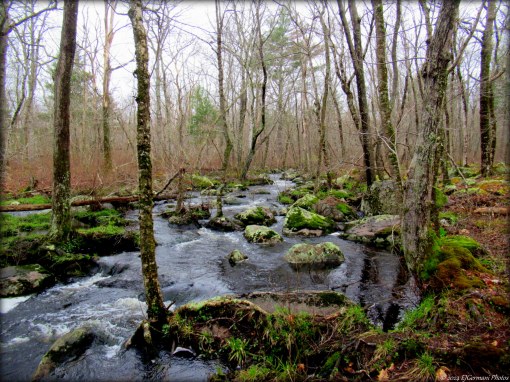
The newest of the publicly open Nature Conservancy properties, Moshassuck River Preserve catapults to the top of the list of trails in Rhode Island you must hike. The property offers two blazed loops, a historic cemetery, old stone dam, a ridgeline, boulder field, a vernal pool, several stream crossings, and the Moshassuck River itself. The trails traverse over the property known once Camp Conklin, a former Boy Scout property, and the abutting property of the MacColl YMCA. For this three mile hike start at the parking area at the bend in Sherman Avenue at the Fairlawn Golf Course. There is a sign here indicating the entrance to the hiking trails. First you will pass the open lawn of the golf course on the left before coming to a river crossing. This is your first glance of the Moshassuck. To the right is an old stone dam. The craftsmanship of the stone work is quite impressive. Next your will bear to the left. There will be a large boulder on the hill to the right. Make note of this boulder as you will need it later in the hike to find the access trail to the parking area. After bearing to the left you will notice the first of the blue blazes. Shortly on the left is the Hayden Memorial, placed here when this was a Boy Scout property. From here you will begin to slightly climb uphill. Turn left at the intersection with the yellow blazes and continue to climb uphill. Soon you will reach the top of a ridgeline with a great view of the forest below. Continuing ahead the rail goes downhill quickly first bending to the left and then to the right. You come to the first of several stream crossings here. This crossing is fairly easy as the placement of stones make for a good crossing. Just ahead on the left is a historic cemetery. The grave markers are small and scattered throughout the area. Next you will come to a significant stream crossing. The Nature Conservancy has plans to build stream and river crossings where needed, but for now choose your stones to make the crossing. The trail now winds through a boulder field before entering onto the YMCA property. The narrow trail comes to a dirt road. Continue straight ahead and follow the dirt road. It bends to the right over a culvert, narrows a bit and climbs uphill. Look for the turn to the right onto a narrow (yellow blazed) trail near the top of the hill. After making the turn the trail dips downhill through an area of boulders, crosses a bridge, then climbs uphill once again and comes to a stone wall. Follow the wall keeping it to your right ignoring side trails through the wall. The trail then bends to the right back onto Nature Conservancy property, descends to a muddy stream crossing. It was in this area we came upon a rather fearless deer. It was well aware of our presence but did not seem to fear us. The trail then climbs uphill passing more scattered boulders. Soon we passed the white blazed trail to the right and shortly after that turned left onto the blue blazed trail. The blue loop winds through the northern part of the property. First passing another small area of boulders the trail climbs up and down several small hills, crosses another small stream, and passes what appears to be a manmade well or spring on the left. The trail from here climbs significantly uphill to the highest reaches of the property before making a turn to the right and descending for quite a while. Keep an eye to the left for a vernal pool. Approaching the bottom of the hill you will come to a stone wall and private property to the left. With a slight turn to the right the Moshassuck River is now to your left. The trail then turns first to the right, then to the left, winding around private property, before rejoining the river briefly once again. A small bridge crossing is just ahead and then you will enter another small boulder field with the river on the left once again. This is a great spot to sit and listen to the water trickle by. The trail then climbs slightly uphill as the river winds away from the trail. Look for a large boulder on the left balancing on a significantly smaller stone. This is the boulder you observed when you entered the property. Just after the boulder turn left and follow the access trail pass the old stone dam back to the parking area.
Trail Map: Moshassuck River.

Trail Along The Moshassuck River