Posts Tagged ‘ Walking Paths ’

Grassy Plain Park – East Providence

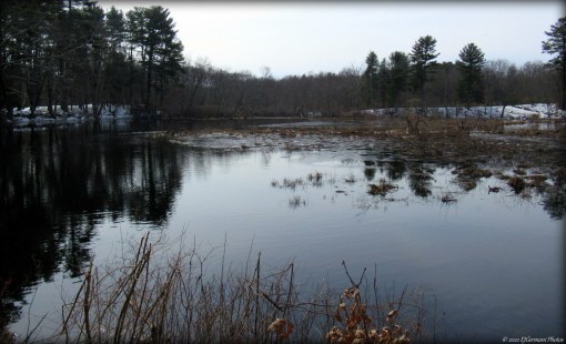
Tucked away in the woods of a residential neighborhood in the Riverside section of East Providence is Grassy Plain Park. The city park developed in the 1970s has received some attention the last few months. The tennis courts and basketball courts have been repaved and new playground equipment has been added to the park. The most recent addition though, is a half mile long concrete perimeter walk. The walk, fairly level, follows the tree line of the park. There is a proposal to add trails to the wooded areas in the future.

GPP

Walk at Grassy Plain Park

Sakonnet River Bridge Bike Path – Portsmouth/Tiverton

  • Sakonnet River Bridge Bike Path
  • Anthony Road, Portsmouth, RI
  • Trailhead:  41°38’18.20″N, 71°13’17.70″W
  • Last Time Hiked: September 12, 2022
  • Approximate distance hiked: 1.4 miles
  • Easy paved path, some incline.

At the four mile mark of Route 24 the highway crosses the Sakonnet River connecting Portsmouth with Tiverton. On the north side of the bridge is a bike path. The path is about seven tenths of a mile and offers two spots to step aside to view the river below. To the north you get a sweeping view of the upper reaches of the Sakonnet River where it meets Mount Hope Bay. Across the four lanes of highway you get a view of a causeway where the Stone Bridge once stood. The bike path was built with intentions of having a future bike path from Fall River to Newport. At night the bridge is lit up and offers different colors for holidays and seasons.

TWRI-SBR01

Bike Path on the Sakonnet River Bridge

Glenlyon Field – East Providence

This city park wedged in the Rumford neighborhood offers a paved walking park just under a half mile long. The path follows the perimeter of the park that also offers a ball field, tennis courts, basketball courts, and a playground.

Glenlyon

Walking Path at Glenlyon

Remington Park – Burrillville

Wedged along a narrow parcel that was once a railway line, you will find a street hockey rink, tennis court, and a quarter mile bike path that leads to the shores of the Clear River. The path leads to a former rail crossing. This is a good spot to observe water fowl.

TWRI-HawRem07

Clear River

Market Square – Woonsocket

  • Market Square – Blackstone River Bikeway
  • Market Square, Woonsocket, RI
  • Trailhead:  41°59’59.80″N, 71°31’1.79″W
  • Last Time Hiked: November 17, 2021
  • Approximate distance hiked: 1.2 miles
  • Easy, paved bike path.

A new section of the Blackstone River Bikeway has arrived in central Woonsocket. The short six tenths of a mile section is all off road from Market Square easterly crossing Main Street to Truman Drive where it crosses then follows the road northerly to its end. After crossing under Court Street you will catch glimpses of the Blackstone River through the trees. At the end turn around and retrace your steps for a 1.2 mile walk.

Trail Map: Market Square.

TWRI-MarketSq

Blackstone River Bikeway Along Truman Drive

Curtis Corner – South Kingstown

  • Curtis Corner – South Kingstown Athletic Fields
  • Curtis Corner Road, South Kingstown, RI
  • Trailhead:  41°27’45.50″N, 71°31’21.57″W
  • Last Time Hiked: May 8, 2021
  • Approximate distance hiked: 1.1 miles
  • Easy with some slight elevation.

Curtis Corner offers a short walk and short hike behind the Middle School. But beware of the flying saucers!! There is a disc golf course here that is quite active. For the first part of the walk, make your way to the walking path that goes by the building by the parking lot. Follow this a bit and turn right keeping the soccer fields and stone wall to your right. The walking path wraps around the field passing another path to the left. Keep right here. The path soon enters the woods and ends at the roadway. Turn right and cross the road. You will soon see a trail head on the left. Follow the well defined trail around the small pond. The trail winds through the disc golf course. At the east end of the pond is a sitting bench with a great view. You are likely to see turtles here. Retrace your steps back to the road, turn left and the parking area is just across the street.

Map can be found at: Curtis Corner

TWRI-SCT2107

Stream Crossing

Poncin Hewitt Field – Attleboro


Poncin Hewitt Field is an athletic complex in southern Attleboro along the Rehoboth border. There is a half mile paved walking path throughout the complex (that is generally plowed when looking for winter walking). At the southern edge of the complex there looks to be a trail, however, it is clearly posted No Trespassing. Enjoy the walking path!

TWRI-PON

Walking Path Plowed In Winter.

Sakonnet Point Path – Little Compton


This is a very short walk just being under a half mile in total. The walkway, open to the public, is provided by the Sakonnet Point Club. The short paved path wraps around a parking lot separated by a post and rail fence. The remainder of the walk is out to the end of the breakwater. The views here are spectacular. To the south is the lower reaches of the Sakonnet River meeting the Atlantic Ocean as well as the lighthouse just off shore. If you look closely you will spot the ruins of the West Island Fishing Club (just to the left of the lighthouse). To the northwest you can spot the Newport Bridge peaking over Aquidneck Island. If you do venture onto the breakwater use caution.

TWRI-20200105-13

Sakonnet Point Light and The Atlantic Ocean

Tourister Mill Riverfront Walkway- Warren


The newly renovated Tourister Mill complex in Warren offers a public walkway along the lower Palmer River. Starting from the designated public parking area at the north end of the complex, the walkway winds along the rivers edge in a southerly direction with views of where the Palmer and Barrington Rivers converge into the Warren River on one side and the historic mill buildings on the other. The end section of the walkway at the time of this walk was blocked off and still under construction.

TWRI-Tourister

The Walkway at Tourister Mill.

Pheasant Hill Beach – Portsmouth


At the end of Pheasant Road just after the railroad tracks and to the right is a parking area for Pheasant Hill Beach. From here you can follow the road a few hundred feet to the walking path the follows the shoreline toward the Mount Hope Bridge. At the end of the path there is a narrow trail that continues ahead. Along this trail are sweeping and stunning views of a marsh to your right, the bridge ahead, and Hog Island Lighthouse to your left. At the end of the trail are a row of boulders. From here turn left and make your way to the beach. From here you can follow the beach back a bit to one of the access points back to the walking path that leads back to the parking area.

TWRI-Pheasant3

Walking Path With Mount Hope Bridge In The Distance.