Archive for December, 2015

DelCarte – Franklin


There are three blazed trails here that traverse the woods around the Franklin Reservoirs. The trails, green, red, and blue, are very well marked and there is an informational kiosk at almost every trail intersection. There is also a very interesting and unique floating bridge that crosses one of the water bodies. The trails wind through areas of thick pine groves and there are some small hills. There were several swans and geese here. At the spillways of the dams are small waterfalls. There is also a boat ramp for kayaks and canoes as well as a playground and picnic area. This is a great location for kids and/or beginners. For more information go to Easy Walks in Massachusetts.

TWRI-1230-6-DelCarte

The Bridge at DelCarte.

Indian Rock – Franklin


This very short two tenth of a mile trail leads you to a very historical location. It is said that a battle took place here between the colonists and the Native Americans during the King Phillips War. A group of Native Americans were camping here preparing to attack the settlement of Wrentham. Word got out that they were here and the colonists confronted them. Several of the Natives were killed. The trail starts at the end of King Phillip Road and then turns abruptly to the right. The trail then splits. Stay to the right and follow the trail slightly uphill. At the top of the hill is the large granite outcrop. There is a significant 20 foot or more drop on the other side of the rock. Be careful near the edge. There are also other short trails on the property. For more information go to Easy Walks in Massachusetts.

TWRI-1230-5-Indian

An Icy Indian Rock.

Knuckup Hill – Wrentham

These two hikes together as one will give you a nice little stroll just over a mile. First is Knuckup Hill, an old ski hill abandoned in the 1980’s. Starting from the Building Inspectors office building off of Taunton Street you first follow the fire road to the right of the building up the hill. The road winds up the hill and can be steep at times (especially during icy conditions). Soon you will see the remains of a ski lift tower on the right. Take the narrow path here and follow it to the overlook. On a clear day you will get a nice view of the Boston skyline. There are a few other trails that traverse over the top of the hill. Explore them! You will find the remains of a fireplace that once was part of the ski lodge. There is also a rather large boulder of note and two water towers. After exploring the hill, retrace your steps back to the Building Inspectors Office. Next is Trout Pond. To the left of the building is another fire road that leads down to the pond. There is a short loop trail that wraps around the pond. You may notice the white blazes of the Warner Trail here. For more information please see the book Easy Walks in Massachusetts.

TWRI-1230-4-Trout

Trout Pond in Winter

Ryan Park – North Kingstown

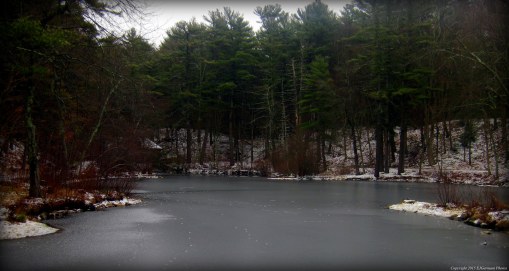
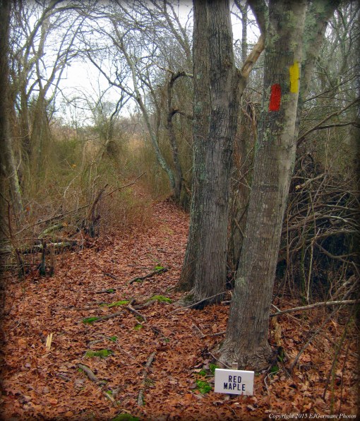
Ryan Park in North Kingstown offers a little bit of everything for everyone and it is easily accessible just off of Route 4 along Oak Hill Road. There are two entrances along Oak Hill Road. For this hike I used the entrance by the cluster of ball fields and then followed the roadway to the boat ramp. (Follow the signs for additional parking until you reach the first dirt parking area on the left. There is a sign by the boat ramp calling it off as a waterfowl hunting area.) Near the boat ramp there is a boulder with a pink blaze on it. This is where I started this hike. I followed the narrow root bound, pink blazed path as it winded through an area with ponds on each side. After crossing a short boardwalk I came to the bridge the crosses a narrow of Belleville Pond. Both the boardwalk and bridge can be slippery when wet. Continuing, I then came to the first of the a couple trail blaze changes. I continued straight now following the green blazed trail. Soon this trail led me to the yellow blazed trail. The yellow blazed trail to the right I would take later on this hike, but for now I continued straight/slightly left now following the yellow blazes. As the trail approached a line of houses the trail started bending to the left. Here the yellow blazes ended and the trail was now blazed orange. After a few hundred feet I was soon upon an old railroad bed. The trail would eventually lead out to the LaFayette Road park entrance. Along the way there is an old cemetery on the left. Most of the headstones are tumbled and destroyed. The two that remain have dates of 1827 and 1865 on them. There are also a couple small stream crossings. From the northern park entrance I then retraced my steps back along the orange trail, onto the yellow trail, to the intersection of the green trail. Instead of following the green trail, I continued straight following the yellow blazes. I passed a couple small ponds along the way. Soon I was at another intersection. To the right were double yellow blazes. I continued straight following the single blazed yellow, stopping occasionally at the small spur trails that led to a duck filled cove. The trail soon comes to a dam and waterfall and two bridges. Along this stretch are sweeping views of the pond. The trail then ends at a gate. I turned right making my way along a dirt road. To the right is the pond and to the left is the men’s softball field. Keeping right at the end of the parking lot led me back to where I had parked. The map provided does not show the trail blazes that are actually along the trails.

Trail map can be found at: Ryan Park.

TWRI-Ryan04

A snowy morning along the yellow trail.

Patriot Place – Foxboro


Patriot Place… known for Gillette Stadium, the home of the New England Patriots, and the sprawling complex of stores around it. Tucked away behind the Bass Pro Shop is a nature trail. The trail is short and easy to walk. This is a good trail for all ages as it is relatively flat. As soon as you enter the trailhead, you descend slightly downhill and away from the bustle of Patriot Place. The trail is a loop consisting partly of a boardwalk over wetlands, an active cranberry bog, and a wooded area. You will catch a glimpse of several birds here including ducks. The bog is usually harvested in the fall. This is a great little walk if you are in the area shopping, dining, or looking for some pre-game activities. (Go Patriots!!)

TWRI-Patriot

Boardwalk Along Nature Trail

Marina Park – South Kingstown


This aptly named park sits between the busy Route 1 and the marinas of Upper Point Judith Pond. The park has just about a half mile of paved pathways. There is an amphitheatre here by the edge of Silver Spring Cove. This park is dog friendly, but they must be leashed. Just across the street there are some benches overlooking the pond.


TWRI-MarinaPark

Marina Park

Tuckertown Park – South Kingstown


This short nature trail, just under a half mile in length, starts behind the historical cemetery and ends by the little league field at Tuckertown Park. The trail passes along a wooded swamp. There are also large clusters of rhododendron here which bloom in late spring/early summer. There were several birds here including several dozen blue jays. A walk down to the picnic area will provide you good views on Tucker Pond.

TWRI-Tuckertown

Rhododendron at Tuckertown

Mill Pond Preserve – Charlestown

  • Mill Pond Preserve
  • South County Trail, Charlestown, RI
  • Trailhead: 41°23’21.72″N, 71°38’22.01″W
  • Last Time Hiked: December 21, 2015
  • Approximate distance hiked: 1.6 miles
  • Moderate due to terrain and navigation.


Tucked away at the end of a long driveway is another Charlestown Land Trust property. There are three main trails on the property. The yellow blazed trail leaves the parking area to the south and makes it way down to the southern end of Mill Pond by the busy Route 1. There are several spur trails along it. Just beyond the gate by the house the red and blue trails head east. The red trail crosses a stream by a small wooden dam of the former trout hatchery. It then travels up and down small hills before crossing a stream and ending at the blue trail. The blue trail starts by the house, passes the red trail and ends at the properties border with the Nature Conservancy. I did a little over a mile and a half while exploring the property.

TWRI-MillPond

The Former Trout Hatchery

Cross Mill – Charlestown


This small Charlestown Land Trust Property is behind the Cross Mill Library along Old Post Road. There is an entrance at each end of the parking lot. The main trail is blazed orange. There is a yellow blazed trail that cuts across the property and there is also an unblazed trail. All the trails only add up to about a half mile. There are a few birdhouses and benches here. There are also several signs depicting the types of trees.

TWRI-CrossMill

Along A Trail At Cross Mill


Champlin Glacier Park – Westerly


Champlin Glacier Park offers several trails that climb up and over hills that flank a valley. Starting the hike from the northern parking lot on Newbury Drive we followed the white blazed trail to the informational kiosk. Here is a trail intersection. We turned left following the green trail uphill. We passed several stone walls before coming to the blue trail intersection. Here we continued straight (slightly left) and followed the blue trail to Charlies Overlook. From here you can see the Atlantic Ocean over both Winnapaug Pond and Misquamicut. After a brief break we continued along the blue blazed trail passing a pond. Shortly thereafter we turned left onto the white blazed trail passing another pond. At the next intersection we turned onto the orange trail (the one to the right) and it led us along a narrow ridge overlooking a valley below. The trail ended at the kiosk. We then retraced our steps to the parking lot.


Trail map can be found at: Champlin Glacier Park.

TWRI-Champlin

Sunrise at Charlies Overlook.