Dunham’s Brook – Westport
- Dunham’s Brook Conservation Area
- Main Road, Westport, MA
- Trailhead: 41°32’37.64″N, 71° 5’14.17″W
- Last Time Hiked: September 8, 2018
- Approximate distance hiked: 2.8 miles
- Fairly easy.
Wedged between Main Road and Route 88, Dunham’s Brook offers nearly 3 miles of trails in three very different and distinctive loops. Starting from the parking area, the trail first follows an open area of grass before entering the woods. At the first wooden bridge look to the right to notice a pond. The next bridge crosses Dunham’s Brook itself. Shortly after that is an area of boardwalk that winds through the thick brush. After taking a sharp right and climbing uphill, you will come to a set of stairs of the left. Go left here first climbing the stairs up to the trail (blue loop) This trail will lead you along the ridge of the hill passing the remains of a stone silo on the left before coming out to a large farm field. The trail bends to the right here. The path to the right (blue loop) will turn back to the south pass a stone wall and end at the orange loop. The path to the left (green loop) will lead you through a large seasonal corn field before entering the woods once again. This section is not shown on the map provided, but is shown at the kiosk at the trailhead. A logging operation was also actively occurring at the time of this hike. Continuing straight the trail will soon turn to the right to complete the loop. Turn left and retrace your steps back through the corn field, pass the silo, and to the stairs. For the last part of this hike, turn left at the bottom of the stairs, follow the trail slightly uphill to the next intersection. Turn left onto the blue trail and follow it to the stone wall at the corn field. Turn right here and follow the orange loop trail as it re-enters the woods. The trail winds through a dense area of woods and wetlands along the southern end of the property. The trail eventually makes a loop and returns to the stairs. From here continue ahead and retrace your steps back to the parking area.
Map can be found at: Dunham’s Brook
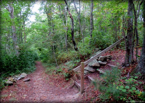
The Stairs at Dunham’s Serves as a Good Reference Point
