Posts Tagged ‘ Beach Walks ’

Mussachuck Grove & Beach – Barrington

This Barrington Land Conservation Trust property is quite a hidden secret and a gem. The walk itself is short unless you want to follow the beach beyond the property. There is parking for a couple cars at the intersection of Appian Way and Grove Street. From here walk up Grove Street a few feet to the entrance of the grove. The small grove offers a loop trail through the predominantly oak tree canopy. At the opposite end of the loop is a spur that leads to the end of Appian Way. Here you will find the beach access in which you can follow the path to the beach. Low tide is particularly good time to visit as nature makes some interesting artwork of the beach sand as the tide recedes. Once at the beach you will notice the nesting area for purple martins as well as several birdboxes on the landward side. The view from the beach stretches from the Port of Providence to Conimicut Point. The view of the lighthouse from here is also quite impressive. There is a small creek that can be easily forded at low tide if you wanted to continue further down the beach for further distance. Just be sure to stay below the high water mark beyond the creek.

TWRI-Mussachuck

Looking Toward The Conimicut Point Lighthouse

Old Harbor – New Shoreham

This walk, based on an on-line in town walk (see link below), covers quite a bit of the sights within a reasonable walking distance of the ferry landing at Old Harbor – Block Island. Starting from the ferry walk straight towards the restrooms then turn left and make your way out to Water Street as if you were heading to Ballards. Turn left onto Water Street and almost immediately across the street is the entrance of the Ocean View Trails. Follow the entrance trail slightly uphill. To the left is a narrow trail that leads done to the beach. Follow it to get some impressive beach views. Return back uphill and make your way up to the pavilion. This was the site of the Ocean View Hotel that stood here up till 1966 when it burnt to the ground. There is a narrow trail behind the pavilion that leads to a small garden then downhill and wraps around the backside and then west side of the property before reconnecting with the main entrance trail. Turn left back onto Water Street and then left onto Spring Street. Follow Spring Street uphill about a thousand feet and then turn right at the 1661 gardens. Follow the access road down to the farm. Here you will see emus and ostriches running about for a rather unique zoo experience. From here follow Spring Street back to the intersection with Water Street and turn left onto High Street and then right onto Weldons Way. There are several rental shops for mopeds and bicycles along the street. You will be approached to rent a moped!! At the end of the street turn left onto Chapel Street. You will pass Saint Andrews Church before coming to Old Town Road where you will turn right. The big white building on the left at the next intersection is the Block Island Historical Society. There is a small fee for a tour of the building. Take a left onto Ocean road and a few feet down is Poor Peoples Pub. This is an island staple and a good spot for lunch. Return back to the intersection and take a left onto Corn Neck Road. Follow it to a small park on the left called Solviken Nature Preserve. There are a few picnic benches here. Cross the street and you will find a set of stairs leading down to the beach. At the bottom of the stairs turn right and follow the beach to its end at the left of the Block Island Beach House/The Surf Restaurant. There is a set of stairs that lead back up to Water Street where you find several shops and eateries opposite of the ferry terminal. This makes for a good day trip walk while visiting the island without means of renting other modes of transportation.

Trail Map: Old Harbor Walking Tour.

TWRI-OHW05

Ocean View Pavilion

The Knubble – Westport

A beautiful spot at the western entrance of the Westport River, The Knubble is a large outcrop at lands end. The small strip of beach is owned by the Westport Land Conservation Trust. A loop walk along Beach Road and the beach itself offers a short half mile walk. There are some parking restrictions, so be aware of those and adhere to them.

TWRI-Knubble

The Knubble at the End of Beach Road

Mackerel-Sheffield Coves – Jamestown

  • Mackerel-Sheffield Coves
  • Beavertail Road, Jamestown, RI
  • Trailhead:  41°29’20.82″N, 71°23’2.43″W
  • Last Time Hiked: September 5, 2021
  • Approximate distance hiked: 0.5 miles
  • Easy beach walk, best at low tide.

The road to Beavertail Lighthouse passes through a small strip of land flanked by the Mackerel and Sheffield Coves. A short beach walk of a half mile can be achieved here by visiting both sides of the road. Mackerel Cove to the south offers views toward the ocean while Sheffield Cove to the north offers a view of Fort Getty and the Jamestown Bridge.

TWRI-Sheffield

Mackerel Cove

Allens Pond West – Dartmouth

  • Allens Pond West
  • Horseneck Road, Dartmouth, MA
  • Trailhead:  41°30’24.53″N, 71° 1’25.18″W
  • Last Time Hiked: May 1, 2021
  • Approximate distance hiked: 2.6 miles
  • Fairly easy trails with rocky beach walk.


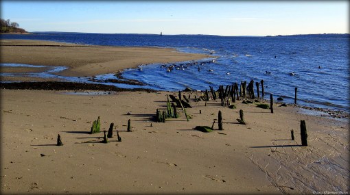
Allens Pond is a Masachusetts Audubon property along Buzzards Bay. The property offers 6 to 7 miles of trails. It is a diverse and beautiful property offering several types of features from beaches to fields to woodlands. With that being said, I have decided to break the property into three separate hikes to maximize visiting all of the trails without having an overwhelming hike distance. This hike, the third, covers the western portion of the property. Starting from the Field Station parking area stay to the left and follow the grass mowed trail towards an opening in a stone wall. The trail crosses through another grass field before coming to a dirt road. Turn left here and almost immediately you will be turning right passing an open gate. You are now on the Quansett Trail. You start getting your first glimpses of Allens Pond on the right. Ahead you will cross a stone wall. Here a rather extensive boardwalk begins. The first highlight is a viewing area to the right. The second, just after the bend is a bridge that crosses over a marshy area. The trail, back on land now, traverses through thickets, pass boulders and more stone walls before coming to a stretch of “stepping stones”. At the next intersection there is a distinctive boulder. Stay to the left here and continue following the Quansett Trail. You will cross a small brook before coming to the Tree Top Trail. Again bear to the left and continue on he Quansett Trail. You will come upon more boulders and a “stretch of green” featuring skunk cabbage and fiddleheads in early spring. For this hike, turn right at the next intersection onto the Fresh Pond Trail. (The Quansett Trail continues ahead here into the central part of the property.) Along the trail to the left is a spur to Poison Ivy Rock. There is a nice view of the cove here and a good spot to take a break. I did not see any poison ivy! Continuing along the Fresh Pond Trail you will soon come to the trails namesake on the right. Look for nesting swans and geese here along with several other birds. The trail then turns to the right passing a sitting area before coming to the “stone bridge”. Here you will get another glimpse of Fresh Pond to the right. After crossing the bridge the trail ends in a bit completing a loop. Turn left back onto the Quansett Trail, passing the stepping stones, boardwalks, and to the dirt road. Turn left onto the dirt road and follow it about a tenth of a mile to an area with sweeping views of Allens Pond. Look for osprey atop the pole, herons, and egrets. There will be a information kiosk on the right with a sandy path. Follow this path to the rocky beach. At the beach you will see the Elizabeth Islands in the distance. On a clear day you may be able to make out the Gosnald Tower near the end of Cuttyhunk, the island to the right. Turn right onto the beach and follow it to the large outcrop. The trail then climbs over the outcrop coming back down the other side to another rocky beach. After the zigzagged stone walls to the right the trail turns to the right coming into a grass field. From here follow the grass mowed path to the parking area. Check out the Bayside Restaurant across the street for their blueberry pie!!


Map can be found at: Allens Pond West

TWRI-APW2103

Stone Walls and Boardwalks

Barrington Beach – Barrington

Barrington Beach overlooks Narragansett Bay with views of Warwick and Prudence Island. The beach is open to non residents in the off season. From the parking lot at the end of Bay Road you will be able to walk in either direction for quite some distance. You will be able to get just about a mile and half in total.

CA-Barrington Beach Color Accent

Barrington Beach at Sunset

Watson Farm – Jamestown


A Historic New England property, Watson Farm is a active working farm on the western slope of Conanicut Island with sweeping views of the West Passage of Narragansett Bay. Because it is a working farm it is only open to the public on certain days. There is also an entrance fee payable at the barn where the self guided walking tour begins. A trail map in a booklet will be provided to you. Also, it is advisable to check the tides before embarking to the shore. The barn itself offers quite a bit of New England history, different tools, saddles, and other equipment is visible. The animals were not in the barn at the time of this visit (other than a lumbering gray cat). Farm animals are likely to be in different areas of the farm at different times. To begin the walk, from the barn follow the dirt road between the barn and historic 1796 farmhouse uphill and then stay to the right. You will pass another farm structure to the right before cresting the hill at a farm gate. Take a peek behind you at the top of the hill. You will catch a glimpse of the towers of the Newport Bridge. Continuing ahead the road turns slightly to the left and the windmill becomes visible. The windmill here at Watson Farm is used to supply water throughout the farm by pumping it from below. Carrying on, the road turns slightly downhill giving you the first glimpses of the West Passage. There are sporadic single standing trees throughout the fields. These trees serve as shade for the farm animals. Soon the road splits. There is a sign here indicating to turn left for the short loop. For this hike continue ahead and downhill to the next split where there is another sign indicating the “Path to the Bay”. Turn left here, you will see a large outcrop of pudding-stone to your right before coming to a four way intersection by a stone wall. Turn right here, keeping the wall to your left for a bit. The pathway continues downhill. You will now have views of the Jamestown Bridge and Plum Island Lighthouse to your right across the fields. At the end of the path there is a gate. If it is closed, be sure to close it behind you after passing through it. The path now narrows as it turns to the left for a few feet, then right and downhill through some trees before reaching the shore. It is best to check the tides before reaching this point. High tide will leave only a narrow strand of beach. It is best to follow the shoreline at low tide as the beach is wider and offers a variety of stones and shells to view. When you reach the shore turn to the left and follow the shore away from the bridge behind you. The land ahead of you is Dutch Island. You will notice a portion of wall that was once of a long abandoned building. Dutch Island served the military for several years before being abandoned entirely. The island is now a State Management Area only accessible by boat. To the left of Dutch Island is Fort Getty, now a summer campground. Following the shore it soon bends to the left. Start looking for the “Buoy Post” where you want to turn left to get back onto the farm trails. Be sure to close the gate once again and continue ahead. From here you will continue straight gently uphill passing first a trail to the left before winding through an old orchard. Next you will pass through a gate, then a stone wall while traversing through large open fields. After the stone wall, the trail turns to the left and climbs gently uphill again before coming to the a trail intersection. Here continue straight ahead passing another stone wall. You will pass a pollinator garden on the right before coming to an old wagon parked behind the old farmhouse. The road then turns slightly to the right back to the barn. For more information click here.

A Lone Tree In A Field

Ninigret Beach – Charlestown

  • Ninigret Beach (East Beach)
  • East Beach Road, Charlestown, RI
  • Trailhead:  41°20’37.88″N, 71°41’22.71″W
  • Last Time Hiked: February 15, 2020
  • Approximate distance hiked: 5.8 miles
  • Fairly easy beach walk.


The beach between Blue Shutters Beach and the Charlestown Breachway is part of East Beach State Park and the Ninigret National Wildlife Refuge. It is a long three mile strand of beach that is not overwhelmed with humans. In the summer a fee must be paid the access the beach and parking is very limited. In the winter the beach is desolate, especially at sunrise. This day was a windless but brutally cold February morning. Hike time temperature was a sweltering 7 degrees Fahrenheit. I came here armed with cameras to catch the sunrise, multiple layers of clothes, but mostly to find solitude to clear the mind. Success! I arrived at the small parking area before sunrise and made my way to the beach. To the east I could see the beacon of the Point Judith Light. To the south I could see the lights of Block Island twinkling. Along the horizon between them, the glows of pink, magenta, fuchsia, and orange setting the sky up for a spectacular sunrise. I turned to the east and followed the empty beach for a few miles. At 6:42 AM, just as scheduled, the piercing light of the sun broke the horizon. The beach suddenly a glow of of the colors in the sky. In the distance I could make out my destination, a dark shadow strip of the breachway stretching into the ocean. As the sun rose into the sky the beach came to life with sea birds. The waves broke gently and peacefully.  I spent only a few minutes at the breachway before retracing my steps back to the parking area. This walk is exactly what was needed. I did not run into a single soul! Also as a side-note, I was still cold when I ordered my breakfast sandwich at Sophie’s (in Exeter) a little while later.

TWRI-EastBeach01

Winter Sunrise

Hull Cove – Jamestown


Hull Cove is a spectacular spot at the end of a short trail in southern Jamestown. The town owned land offers a short walk of a little over a quarter mile out and back with some wandering along the beach. When the surf is up, you will likely find surfers here.

TWRI-Hulls2

Rough Sea at Hull Cove (Passing of Hurricane Dorian – 2019)

Head’s Beach – Jamestown


Head’s Beach is a small town owned beach on the west side of Jamestown with sweeping views that include the Jamestown Bridge, Plum Island Light, and Quonset Point. This walk is very short, just over a quarter mile, but the beach itself is serene. Parking is limited to residents from May 15th to October 15th.

TWRI-Heads

The Jamestown Bridge From Head’s Beach