Archive for November, 2016

King Preserve – North Kingstown

  • King/Benson Preserve
  • Boston Neck Road, North Kingstown, RI
  • Trailhead: 41°30’56.02″N, 71°25’23.72″W
  • First Time Hiked: November 25, 2016
  • Last Time Hiked: December 4, 2021
  • Approximate distance hiked: 3.5 miles
  • Fairly easy with slight elevation.

Named for Dave King, the first executive director of the Champlin Foundations, this is Rhode Islands newest Nature Conservancy property that now has trails open to the public. It is so new in fact that the trails in the Benson Preserve property are still under development. The property is just north of Casey Farm and stretches from Boston Neck Road westward to the Narrow River. The blue trail from the main parking area meanders westerly into the property, passing stone walls and small boulders, for about a mile before coming to the yellow trails. Turn left at the yellow trail and follow it to its end. Along the way look for a rather unusual rock on the right that seems to point. You will pass a yellow trail to the right as well. You will return on this trail. At the end of the yellow trail you will come to a four way intersection. The yellow loop trail is to your immediate right and a trail spurs to the left to Casey Farm. Ahead and to the right is the white blazed Pettaquamscutt Trail. Follow this trail to two of the preserve features. The first on the left is a small beach that overlooks Narrow River. This is an old Girl Scout Camp beach. Back on the white trail you will soon find yourself walking through a canopy of tall spruce trees. Here we spotted a fox. The white blazed trail then turns to the right and comes to a set of trickling waterfalls. Continuing along the trail you soon cross onto the Benson Preserve. There is signage indicating that the trails are still being developed. From here you can retrace your steps or forge ahead follow the un-blazed trails. If you choose the later be sure to use some sort of GPS in case you need to backtrack and be very aware of your footing. The white trail is blazed for a few more hundred feet. Soon you will see a trail to the right. It is currently marked with pink survey flagging. Following this flagging (soon to be blazed white) and carefully following the currently less defined trail you will come to a wood footbridge at a stream crossing. A few feet after that you will turn left onto the blazed yellow trail. Follow this trail to its end turning left again onto the main yellow trail. From here retrace your steps back to the parking area following the yellow then blue trails. Hunting is allowed on this preserve, be sure to wear orange during hunting season.

A note about the bordering Casey Farm property: Casey Farm is open to the public during daylight hours for hiking trails at Casey Point or those adjacent to King Preserve. Please note dogs must be on leashes, clean up of course, and respect the young people and farm animals by keeping dogs away from the farmyard and fields. Access Casey’s woodland trails via the King Preserve. Camp Grosvenor is not open to the public for hiking. Access Casey Point on Narragansett Bay via the gate on Boston Neck Road. We are working on getting better signage. Feel free to contact me with any questions: Jane Hennedy, site manager, 401-295-1030 ext. 5, jhennedy@historicnewengland.org.

Trail Map: King/Benson
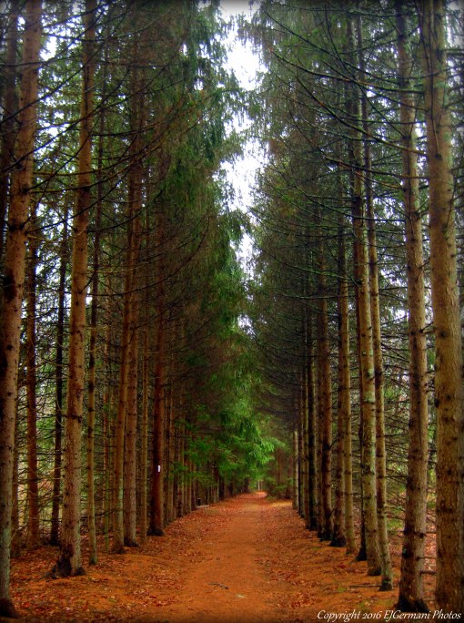
twri-king

Spruce Grove

Pasquiset Pond West – Charlestown

  • Pasquiset Pond – West
  • Narragansett Trail, Charlestown, RI
  • Trailhead: 41°24’42.67″N, 71°37’12.49″W
  • Last Time Hiked: November 19, 2016
  • Approximate distance hiked: 1.5 miles
  • Fairly easy with slight elevation.


The Pasquiset Pond Preserve in Charlestown has two separate trail systems. The trail that leads into the western part of the preserve is at the end of Narragansett Trail.  As a matter of fact, this was once part of the Narragansett Trail when it ran from Lantern Hill in Connecticut to Wordens Pond in South Kingstown. This road has no signage and has two houses at the end of it. There is a small spot for a vehicle to park in front of the wooden barrier at the very end of the drivable road. Be sure not to block the residences access to their homes. The trail that leads into the preserve is actually a continuation of Narragansett Trail. It is a wide footpath that weaves through the southern edge of the property winding over gentle hills. There are some nice stone walls along the way and a couple spur trails. A little over a half mile the trail splits. The trail to the left, a continuation of Narragansett Trail, eventually leaves the property and comes to a nearby farm. Stay to the right here and follow the trail to a remote large grassy field. If you are lucky you will catch a glimpse of wildlife. The field and nearby trees are a haven for birds. I noticed several at the time of this hike including blue jays, woodpeckers, cardinals, and chickadees. After spending a moment at the field retrace you steps back to the trail-head. The remainder of the trails at this preserve are off of Old Coach Road about a quarter mile away.


Trail maps can be found at: Pasquiset Pond

twri-pasw1

The Field At Pasquiset Pond

Pasquiset Pond East – Charlestown


The Pasquiset Pond Preserve in Charlestown has two separate trail systems. Along the eastern edge of the preserve is a short quarter mile trail that winds through one of the most beautiful pine groves in Rhode Island. The towering elder pines sway gently above the younger spawns that cover the forest floor. Although a very short stroll, it is worth the stop if you are in the area. There is a sign for the preserve at the northern entrance but parking is available a few hundred feet down the road at the unmarked southern entrance. The remainder of the trails at this preserve are off of Narragansett Trail about a quarter mile away.

Trail maps can be found at: Pasquiset Pond

twri-pase1

Trail Through The Pine Grove

Richard Trails – Charlestown


This is property off of South County Trail has a small network of blazed trails that traverse up and over a couple small hills. The property is maintained by the Charlestown Conservation Commission. The trails pass under several types of trees including oaks and pines. There are also several birdhouses placed throughout the property. Exploring just about all of the trails will give you a hike of just over a mile.

twri-richard

Late Autumn at Richard Trails

Meadow View Bike Path – Warwick

This short bike path connects two neighborhoods on Warwick Neck. The paved bike path was once part of a street that the city of Warwick closed. There are two wooded parcels on each side of the bike path that have short spur trails. The trees and shrubs make for good bird watching.

twri-mvbp

Along The Bike Path

Burton Woodlands – Glocester

  • Burton Woodlands
  • Joe Sweet Road, Glocester, RI
  • Trailhead: 41°54’7.30″N, 71°41’52.70″W
  • Last Time Hiked: November 8, 2016
  • Approximate distance hiked: 1.9 miles
  • Fairly easy with slight elevation.


The entrance to this Glocester Land Trust property is just about across the street from where the Cemetery Trail of Sprague Farm comes out onto Joe Sweet Road. In fact this lesser known trail system would make a good addition to a hike at Sprague Farm. The main trail is a wide cart path that is covered in pine needles and heads in a southerly direction. The trail passes a narrower trail and a cellar hole to the left before heading onto private property. The narrower trail loops crossing over a small babbling brook. The brook could be impassable after heavy rains as it is quite deep at the trail crossing. There is also another narrow trail that seems to dead end toward private property as well. The trail system is probably about a mile to a mile and a half in total. I did some backtracking while exploring this property giving me a little more mileage.

twri-burton2

Main Trail at Burton Woodlands