Archive for December, 2017

Cote Preserve – North Stonington


Opened in September of 2017, the Samuel Cote Preserve is one of the newest trail systems in the area. The preserve is rather small and offers a great view of Spalding Pond. The entrance is along Clarks Falls Road and the parking area is a few hundred feet along a laneway on the left. From the parking area follow the laneway passing a large corn field on the right. Soon is a sign on the left for the trailhead. The blue blazed trail winds through the woods passing a massive white pine along the way. The trail comes to an old cart path called River Road. At each end of the road is private property. Please respect that and stay on the marked trail system. Turn right onto the cart path and follow it along Spalding Pond. There are several spur trails that lead to a trail that runs right along the shore. Back on the cart path you will see a sign for Trail 2, still blazed blue. Follow this trail back to the laneway and turn right. This will lead you back to the parking area.


Map can be found at: Cote Preserve.

TWRI-Cote

Blue Trail Along Spalding Pond

Quequechan River – Fall River


The Quequechan River runs from South Watuppa Pond to the Taunton River and once had a series of eight waterfalls. Quequechan is a Wampanoag word meaning “falling water” in which the city received its name. Most of the river over the years has been built over or channeled for the massive mills that sprouted up along the river. Today a the river is the centerpiece of a former railroad bed that has been converted to a walking path/bike path. Starting from a parking area at the end of Wordell Street follow the paved path along the soccer field at Britland Park. Here you will find a informational kiosk showing the trails. Staying to the right I followed the main stretch of the trail down to Quequechan Street before turning around and retracing my steps. The trail passes over a series of wooden bridges and the river serves as a foreground of the historic mills. Once back to the kiosk, I opted to follow the paved path along between the soccer field and the river to its (currently) dead end and back. The map indicates that this may become a loop in the future. Once back to the kiosk again, I retraced my steps back to the parking area.

TWRI-QQC

The Fall River Mills serve as the backdrop of this walking path.

West Hill Dam – Uxbridge/Northbridge

  • West Hill Dam
  • Hartford Avenue East, Uxbridge, MA
  • Trailhead:  42° 6’12.84″N, 71°36’30.60″W
  • First Time Hiked: December 19, 2017
  • Last Time Hiked: July 7, 2018
  • Approximate distance hiked: 2.7 miles
  • Fairly easy with some slight elevation.


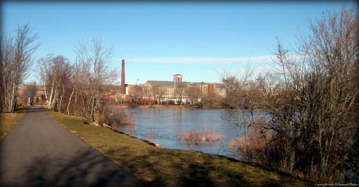
In 1955, Hurricane Diane caused extensive flooding particularly along the Blackstone River including the city of Woonsocket, Rhode Island. In 1960, the West Hill Dam was completed and almost immediately tested by Hurricane Donna. The cities and towns downstream did not flood. The dam and the property around the dam is owned and maintained by the United States Corp of Army Engineers. The property is open to passive recreation such as swimming, picnicking, and hiking. There are three blazed trails on the property. The orange blazed Woodland Trail encompasses almost the entire property. A yellow blazed Grassland Trail meanders through the southwestern section of the property. Lastly the green blazed West River Trail loops in the center of the property. For this hike we started from the parking lot at the southern Access Road off of Hartford Avenue East. Walking north along the road we soon came to a kiosk warning of hunting season. Blaze orange is required here from October to January when hiking. Turning left we started to follow the gravel road that is blazed with orange diamond markers. The road is slightly raised above the surrounding terrain for a bit. At the intersection, turn to the right and continue to follow the orange blazes. The trail, still following a road, winds through a grove of hemlocks and is flanked by small ponds. Soon you will start seeing stone walls and a large granite bollard with a “N” carved in one side and an “U” carved in the other. This is the town line marker between Uxbridge and Northbridge. Shortly thereafter the orange blazed trail meets with the yellow blazed trail. For this short stretch follow the yellow blazes. The orange blazed trail runs parallel on the other side of the wall but the views are better along the yellow trail. To your right is a sweeping view of a small valley and the grasslands that the West River passes through. The yellow blazed trail soon splits to the right, stay left and pick up the orange blazed trail once again. Next there is a fairly large cellar hole on the left. Soon after that you will come to a road. Stay to the right here and follow the road to a parking lot on the left. By the kiosk is the beginning of the green blazed trail. This trail is about a half mile long and winds up and down hills as it loops through the forest of pines between a pond and the West River. There are several spur trails in this area, however, the green blazes are abundant and easy to follow. At the top of one of the hills is a bench to take a break. There are several bird feeders below that attract birds such as titmouse, nuthatch, and chickadees. Taking a moment to take in the sights we could also hear woodpeckers in the distance. Continuing along the green trail we soon came to the road once again. Turning left, we crossed a bridge over the West River. Along the road on the right is the Harrington Pool Picnic Area. There is a fee in the summer to swim and picnic here. After passing through the parking lot stay to the right of the information kiosk and follow the orange blazes once again. At the next split, stay to the right again following the orange blazes. The trail soon turns to the south and slowly climbs uphill as it winds through more forest. There is an occasional seasonal brook along the way and several large boulders. Soon the trail comes to the massive earthen dam. The walk across the top of the dam offers another sweeping view of the valley below. At the other end of the dam a small bridge crosses the West River nearly fifty feet below in a gorge. From here follow the access road back to the parking area.


Map can be found at: West Hill Dam.

TWRI-WHD08

View From Upon The Dam

Roger Williams National Memorial – Providence


This block long city park offers brick walking paths from one end to the other. It is also where Roger Williams, the founder of Providence, settled in 1636. The park, maintained by the National Park Service, offers several kiosks with historical information, as well as a visitors center in a centuries old building. On the parks property is the fresh water spring that the City of Providence first grew around, several memorials, and gardens. Free two hour parking is available on site on the Canal Street side.

TWRI-RWNM

Brick Walk In The Park.

Blue Beach – North Kingstown


Blue Beach is well hidden among the industrial complex of Quonset Point. The stone dust path leads from a small parking area to the beach that faces south on Narragansett Bay. From the beach you see the Jamestown Bridge in the distance. There is a brook that breaks the beach at times making the walk rather short. From this beach to the southwest you can catch a glimpse of the Poplar Point Light about a mile away.

TWRI-BlueBeach

Blue Beach on a Winter Afternoon

Third Beach – Middletown


Third Beach in Middletown is a haven for beach goers in the summer months. With that said, the “off-season” is the best time to walk this stretch of beach. The beach faces the Sakonnet River just north of Sachuest Point. The beach is often visited by several species of birds as the beach is adjacent to a National Wildlife Preserve and the nearby Norman Bird Sanctuary. A fee to park will be charged during the beach season.

TWRI-ThirdBeach

Third Beach on a Winter Day.

Weetamoo Woods East – Tiverton

  • Weetamoo Woods East
  • Lake Road, Tiverton, RI
  • Trailhead:  41°35’14.25″N, 71° 9’45.37″W
  • Last Time Hiked: December 9, 2017
  • Approximate distance hiked: 3.1 miles
  • Fairly easy with some rocky footing.


Weetamoo Woods in its entirety is easily one of the best places in Rhode Island to hike. The last time I hiked Weetamoo I did about five and a half miles of trails that are described in a Ken Weber book. For this hike I opted to explore the remaining trails in the eastern end of the preserve. Starting from a small parking area on Lake Road, myself and a couple friends first followed the red blazed trail into the property. The trail is quite rocky in areas and footing can be a little challenging. Take your time here if the rocks are wet. Soon we came to a four way intersection (Waypoint 5). The red blazed trail intersects with a blue blazed and orange blazed trail, both on the left. Here we turned onto the orange trail and soon stumbled upon a cellar hole on the right. The trail passes a few stone walls and traverse through an area of beech and hollies. We then turned right onto the Meadow Trail (marked with a sign/Waypoint 6). This trail first crosses a gas easement and winds through the woods before coming to a large meadow. The trail continues with the meadow to the left and a long stone wall to the right. At the far end of the meadow you will catch your first glimpse of Borden Brook below on the right. The Meadow Trail ends at the yellow blazed trail where we turned right. This trail first crosses over Borden Brook and then follows an old cart path for a bit before turning right in the woods. Be sure to keep an eye for the yellow blazes for the turn as the cart path continues straight ahead. There are a few trail intersections here. Continue pass the blue blazes and then follow the red blazes. Soon you will come to Borden Brook again. Here you will find some rather impressive stone work. First, are the remains of an old sawmill complete with large stone walls. Second, step off the trail and follow the brook a few steps down stream to few the craftsmanship of the stone arch bridge. From the sawmill site you could either follow the red or blue blazed trail to the east as they both lead to the same trail intersection ahead. We opted to stay to the left and follow the red blazed trail as it climbed steadily uphill before crossing the gas easement once again. Shortly after way came back to Waypoint 5. From here we retraced our steps back along the red blazed trail to the parking area.


Map can be found at: Weetamoo Woods East.

TWRI-WeetEast02

Along The Orange Blazed Trail

Franklin Farm – Cumberland

  • Historic Metcalf Franklin Farm
  • Abbott Run Valley Road, Cumberland, RI
  • Trailhead:  41°57’59.58″N, 71°23’38.37″W
  • Last Time Hiked: December 3, 2017
  • Approximate distance hiked: 1.4 miles
  • Easy with some small hills.


In the rolling hills of Northeast Rhode Island is Franklin Farm. The 65 acre town owned property was once a dairy farm now used for community gardening and historic preservation. The farm consists of an old 19th century farm house (currently under restoration) and a turn of the century dairy barn. On each side of Abbott Run Valley Road are large fields with farm trails that are open to the public. The fields are separated from the winding road by century old New England stone walls. Parking is available at the dairy barn. For this walk, first cross the street to get to the East Field. The entrance to the east field is marked with a sign at an opening in the stone wall. Use caution while crossing as there is a significant blind spot for approaching traffic. Once entering the East Field turn to the left and you will see a post with the number 1 on it. The farm trail follows the perimeter of the field and there are 10 numbered posts all the way. From the front of the field looking to the east offers a great wide open view of the sky. Sunrises can be spectacular here. When you are on the backside of the field you can catch glimpses of Rawson Pond down the bottom of the hill. After completing the loop cross back over to the West Field. Going up the driveway and right around the dairy barn back towards the old chain link fence you will find a post with the number 1 on it. The farm trail is again marked by numbered posts that leads you partly along the perimeter and partly across the farm fields. There is a small pond along the way that is a small haven for birds offering cover of shrubs and a small tree. I came across an owl here who seemed quite interested in my presence before flying off. The marked farm trail ends at the small gardens and chicken coup at the backside of the farm house. From here turn left to the parking area. The farm is active in the spring and summer months with gardeners and children at programs. The farm trails are open to the public from dawn to dusk. Do keep in mind though to wear proper shoes as the trail is all grass. The frosty farm trail quickly turned in morning dew on this walk.

TWRI-FFarm01

Perimeter Path in the East Field