East Bay Bike Path South – Barrington/Warren/Bristol
- East Bay Bike Path South
- Metropolitan Park Drive, Barrington, RI
- Trailhead: 41°45’12.02″N, 71°20’54.74″W
- Last Time Hiked: August 23, 2016
- Approximate distance hiked: 8.4 miles
- Easy to moderate due to distance.
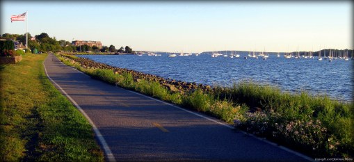
After walking the northern end of the East Bay Bike Path, I decided to finish what I started. The southern end of the oldest bike path in the state winds along the former Providence, Warren, and Bristol Railroad through Barrington, Warren, and Bristol. Along the way there are several points of interest as the paved path passes through the East Bay neighborhoods. Starting at Haines Park, one of the oldest State Parks, I started making my way south. Almost immediately I could hear the sounds of the dog park just beyond the trails and woods to the left. Soon the bike path crosses the lower end of the Annawomscutt Brook just before it dumps into Allins Cove. Immediately after that the bike path makes its first of several road crossings in Barrington at Bay Spring Avenue. To the right is a large brick building that was once a mill. It is now a condominium building. This section of Barrington was its industrial center will mills producing leather and lace products. This building is the only surviving building of that era. Also at this road crossing is a memorial to residents of West Barrington that have lost their lives in wars. Next the bike path crosses Alfred Drowne Road in the neighborhood that was once known as Drownville where one of several railroad depots were located in Barrington. The neighborhood was known for its oyster operations and the land was mostly owned by the Drowne family and later the Blount family known locally for their current clam shacks and seafood products. After crossing Washington Road the bike path enters a half mile stretch of trees and residential neighborhoods before coming to Little Echo Pond. Here, and the surrounding ponds, there was once an icing operation, but the icehouse that sat on the opposite side of the pond is long gone. On each side of the bike path there are small Barrington Land Conservation Trust properties with short trail systems. Both Lombardi Park and Andreozzi Nature Preserve are marked with signs at their trailheads. Just before South Lake Drive on the right was the location of the Nayatt Depot, the next railroad stop in Barrington. After crossing South Lake Drive you will notice the greens of the Rhode Island Country Club to the right. This golf course is one of the most prominent ones in the state hosting the CVS Charity Classic each year. The next road crossing is Middle Highway, after crossing it the bike path passes several trails on the right. These trails are part of Veterans Park which surrounds Brickyard Pond. Today the pond is used for mostly fishing. In years past, there were mills in the area that made bricks. Clay pits in the area supplied the material to make the bricks. Workers would dig these massive pits and in time the pits would fill with water. After the operations ceased in the area and the pumps shut down, the pits filled with water. Hence, the creation of Brickyard Pond. Many buildings on the East Side of Providence were built with the bricks made in Barrington. The bike path also passes the Bayside YMCA before approaching County Road. Just before the main road there is a plaza on the right that offers several shops for a break. There was also a train depot here. On the left is the Daily Scoop, a local ice cream shop. After crossing Route 114, the bike path then passes through a tunnel of trees, then passes Police Cove Park, before emerging out to the Barrington River. Here is the first of two bridges in Eastern Barrington that connect the southern end of New Meadow Neck to Barrington and Warren respectively. The first bridge, crossing the Barrington River offers view of the river northerly toward Hundred Acre Cove. The view to the south is that of is similar of that of the second bridge that crosses the Palmer River. They both look toward the bridges that carry Route 114 over the water crossings and the marinas beyond them. The two rivers come together just about a half mile south to form the Warren River. After crossing the second bridge you are in Warren. You will notice the large brick building to the south that once was the home to American Tourister, a maker of travel luggage. To the north is Grinnel Point with its windswept grass. The bike path then starts to turn to the south and into the heart of Warren. Houses and side streets become very frequent in this stretch. To the left you first pass Belcher Cove and its wooded shoreline. At the Brown Street crossing and to the left you will notice the remains of an old brick wall by the fenced in area owned by National Grid. This wall was once part of the old power station that was used by the railroad. Soon you will start to see the steeples of the nearby churches through the cluster of homes. The bike path then crosses Market Street and Child Street, passing a Dels Lemonade, before coming to a large parking area behind Town Hall, Fire Station, and Police Station. It is in this area that a spur line to Fall River split from the main track and headed east. The East Bay Bike Path follows the former line to Bristol from here. (The Warren Bike Path to the east follows a section of the spur trail). After passing a well-placed bicycle shop and Franklin Street the bike path comes out to Main Street. There is a traffic light with a crosswalk here. It is a very busy intersection, do not attempt to cross without using the crosswalk and light. After crossing the street the bike path continues south and soon passes Burrs Hill Park. The park offers basketball courts, tennis courts, and a ball field. There are also free concerts here. Through the park you can see the water and Warren Town Beach. The bike path continues through residential neighborhoods after passing under Bridge Street through a tunnel that replaced a former railroad bridge. The bike path is also flanked by post and rail fence for quite a while. Soon the bike path passes an area known as Jacobs Point to the right. The large salt marsh, abundant with cattails and wildflowers, offers a single trail to the beach. Just after Jacob’s Point the bike path enters Bristol and soon comes to the McIntosh Wildlife Refuge. This Audubon property spans from Route 114 to the Warren River on both sides of the bike path. To the left is access to the trails through the fields by the Educational Center. To the right is the long boardwalk that reaches out to the river. The bike path then continues through more residential areas with several road crossings before coming to Colt State Park. Along this stretch you can catch glimpses of Narragansett Bay including the Conimicut Lighthouse. After crossing the entrance road to Colt State Park the bike path passes Mill Pond to the right where you are likely to catch glimpses of cormorants and egrets. After passing Poppasquash Road the bike path follows the upper reaches of Bristol Harbor before ending at Independence Park and the edge of Downtown Bristol. Here along the Bristol waterfront you will see several boats docked and the old brick buildings in the distance. If you still have a little walk left in you, the waterfront and downtown offers a great walk on its own
Trail maps can be found at: East Bay Bike Path South
The Bike Path By Bristol Harbor
