Turner Reservoir – East Providence/Seekonk
- Turner Reservoir
- Pleasant Street, East Providence, RI
- Trailhead: 41°49’48.68″N, 71°20’39.48″W
- First Time Hiked: June 2, 2013
- Last Time Hiked: September 26, 2021
- Approximate distance hiked: 2.7 miles
- Easy.
June 2023 – Please use caution while hiking the Turner Reservoir Loop Trail due to bridge construction. The bridge is open and the loop can be completed, however, the sidewalks on the bridge are still under construction.
The Turner Reservoir was flooded in the 1930’s and supplied drinking water to the residents of East Providence for several years. Today the reservoir is used for passive recreation. There is also a 2.7 mile loop around the reservoir and Ten Mile River that is mostly a wooded trail, but includes boardwalks and some road walking. There is a parking lot along Pleasant Street opposite Hunts Mills that has an informational board about the trail and its surroundings. Following the dirt trail along the west side of the Ten Mile River you will soon come to a grassy area near the Turner Dam. Continue to follow the grassy shore of the reservoir to a trail the leads into the woods. This section of trail is rather narrow as it follows the shore of the reservoir behind a residential neighborhood before coming to Newman Avenue. Here you turn right (being aware of traffic) and cross the causeway between the Turner Reservoir and Central Pond. Here you cross into Seekonk and then right onto Arcade Avenue. Just north of utility pole 1416 a blue blazed trail into the woods appears. This long stretch of trail follows the shores of the reservoir once again passing behind the Seekonk High School. Along the way there is a side trail that dead ends onto a peninsula that has sweeping views of the reservoir. The wooded trail ends back at the earthen dam where there are some more sweeping views of the reservoir. From here, walk down the hill and the loop continues along a series of boardwalks that wind through the wetlands along the river. The trail then ends at another parking area along Pleasant Street. Turn right and cross the bridge over the Ten Mile River to reach the first parking area.
Trail map can be found at: Turner Reservoir.

Reservoir Panoramic
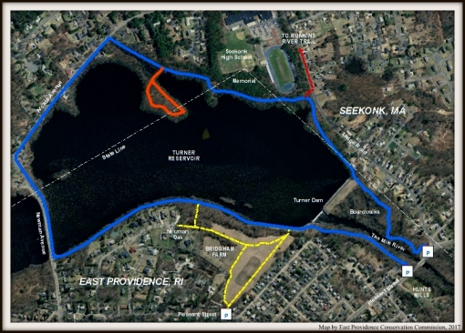
Turner Reservoir/Bridgham Farm Color Map (2017)
