Archive for July, 2017

Tablerock Hill – Lincoln

  • Tablerock Hill – Lincoln Woods State Park
  • Stump Hill Road, Lincoln, RI
  • Trailhead: 41°53’42.13″N, 71°25’36.62″W
  • Last Time Hiked: July 23, 2017
  • Approximate distance hiked: 2.5 miles
  • Moderate due to terrain, navigation can be difficult.


A few quick notes about this hike. Lincoln Woods is notorious for having many unmarked trails that one could easily get lost on. It is highly recommendable that you use a GPS device if you choose to embark on this hike. Although I tried to keep it as easy as possible (as far as navigation) I think improvements can be made. Some of this hike is road walking and I do believe there are other trails that can eliminate that. I fully intend on returning to this area of Lincoln Woods to explore further and finalize a route.


This hike starts at the dam at the eastern end of Olney Pond in Lincoln Woods. There is a parking area suitable for about 15 cars. At the north end of the parking lot is the Jodi Lussier Memorial. Pass the rock and veer left to the right of large outcrop onto a trail that leads into a small valley.  Stay to the left and follow the wider trail that approaches the pond. To the right just before the pond is a trail to the right that climbs uphill. At the top of the hill you will encounter your first experience of multiple trails to choose from. For this hike, stay to the left to parallel the pond. The trail soon dips close to the shore and is marked with red squares. The trail winds, with the pond to left and a hill with boulders on right, up and over small hills following the red square blazes. Along the way there are several spots to view pond. Ahead the trail splits. The trail to the right comes out to an old woods road that you will be on later. For now stay close to the pond. The key is to continue ahead taking lefts to continue to parallel the pond. By doing so you will turn onto a peninsula onto a trail that leads out to Sunset Point. The trail turns to the right, still following the shore, around the point and up to a rock outcrop that overlooks the pond. From here continue to follow the trails along the ponds edge and it will come back to the old woods road. Turn left here and follow the road downhill, again continuing to follow the shore. The aptly named Boulderwood Cove is now on your left. To be sure you are where you should be, you should see a single boulder emerging from the water at this point. Ahead is another multiple trail intersection. Turn left and the trail almost immediately splits. Stay to the left again following the path by the shore once again. Another split is ahead, again stay to the left. Continuing straight ahead there are a couple spur trails to the right you will ignore. Soon you will pass a large balancing boulder on the right. Continue straight ahead following the most defined trail until you reach a flat area surrounding you with large rocks. Here the trail splits again. This time stay slightly to the right (straight) and up the small hill. This trail and another merge at the top of the hill. Stay to left towards the massive boulders. Continuing ahead the trail you are on merges with another. Continue ahead to road passing through picnic site 59. Across the road is picnic site 27. To the left of the site is the trail that scrambles uphill. Cross the road and follow this trail uphill to another massive ledge. Stay to the left of the large rock and follow the base of it to the other side. Continuing the trail narrows and continues straight ahead following faded green dots. Soon the trail abruptly turns left down a rock outcrop into a small valley and crosses a stream. The trail narrows even further, then takes sharp right at a large boulder. Follow the face of the boulder, the trail turns slightly left and then continues straight to Quinsicket Road. Turn right follow road passing picnic sites 29 through 32 on the right. On the left you will notice signs indicating that the trails are used by horse back riders. Follow the paved road up and over a significant hill. As the road starts to climb up again it bends to the left. There is a parking area on the right. Turn right here through the parking area toward row of concrete blocks and rocks that block the old woods road. Grass covered at first, and blazed blue, this trail heads east. To the right is the top of Tablerock Hill. The trail then starts to descend and becomes quite rocky. At the next split the blue blazes stay to left. Here you want to stay to the right and go downhill. The next intersection, at the bottom of the hill, turn right and follow dirt road that leads to picnic sites 2 and 3. Continuing pass the picnic sites you will soon turn right onto the road that wraps around a large field on the left. On the right is the entrance of picnic site 4. At the back of the site is a large ledge with an inscription in it about Bobby Donato, a local, who served in the United States Marines. Retracing you steps back to the road. Continue to the entrance of picnic site 5. Here at the sites entrance is a large outcrop known as Pulpit Rock. It is said that Metacom, a Wampanoag leader, would address his warriors here. Just beyond the picnic site are two trails. For this hike take the one to the left. It passes a small quarry on the left and a small pond on the right before it starts climbing uphill with a stone wall on the left. The trails soon come together, stay to the left here on the more defined trail. This trail continues to climb uphill and soon bends to the right. Ignore the trail to the left and continue another 30 feet or so to the next trail intersection. It is here you will turn left and follow the trail passing a boulder on your right. Continue straight, staying to the left trail downhill as it traverses over an outcrop and then soon a wooden bridge over a stream. To your left are picnic sites 10 and 11 and Goat Rock. For this hike continue straight. The trail here is a wide dirt path that also passes picnic sites 13 and 14 again on your left. Continue straight to the next intersection then veer to left. This trail leads you to the backside of some more picnic sites. Stay on the trail as it bends to the right up and over one last hill. At the top of the hill you will see the road ahead. This trail ends at the road intersection, cross the road and continue straight. You are now on Stump Hill Road and your car is ahead on the right.


Trail map can be found at: Tablerock Hill.
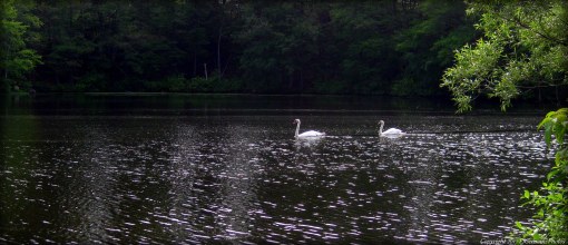
TWRI-TRH02

Boulderwood Cove

TWRI-Donato

Inscription In Donato Rock at Lincoln Woods.

Point Judith – Narragansett

  • Point Judith – Camp Cronin
  • Ocean Road, Narragansett, RI
  • Trailhead: 41°21’44.47″N, 71°29’8.45″W
  • Last Time Hiked: July 22, 2017
  • Approximate distance hiked: 0.5 miles
  • Rocky beach walk, otherwise easy.


Part of the South Shore Management Area on the western tip of Point Judith, this little spot known as Camp Cronin offers a few different terrains. There is a small walkway, by the Point Judith Fishermen’s Memorial, that leads up to a hill that offers a general view of the surrounding area. Then on each side of the breakwater are small beaches. The one to the east, exposed to the ocean, is very rocky and only suitable for walking during lower tides. The beach to the west, inside the safe harbor, is small and sandy. Exploring a little of each will give you a stroll of up to a half mile. The view of the Point Judith Lighthouse is phenomenal here. You are likely to find photographers, fishermen, and beach-goers here on most days.

TWRI-PJLIGHT

Point Judith Lighthouse


Riverfront Park – Attleboro

  • Judith H. Robbins Riverfront Park
  • Riverfront Drive, Attleboro, MA
  • Trailhead: 41°56’30.54″N, 71°17’10.90″W
  • First Time Hiked: July 20, 2017
  • Last Time Hiked: November 17, 2018
  • Approximate distance hiked: 0.5 miles
  • Easy.


Attleboro has just opened a new park along the banks of the Ten Mile River, transforming a bleak industrial strip of land into an appealing spot just outside of downtown. The new park, dedicated to former mayor Judith Robbins, offers a short quarter mile bike path/walking path that is flanked by grass and perennial gardens. There are several picnic tables and sitting benches if you care to linger for a bit for lunch, a break from the day, or waiting for a train as the Attleboro MBTA station is just across the street.

TWRI-RFPATT02

Riverfront Park

Newport Mansions – Newport


The city by the sea has a long history, from the American Revolution to the America’s Cup. Newport’s most famous attractions though are the mansions built by some of America’s wealthiest people. This walk visits most of the mansions and includes a section of the famed Cliff Walk. The walk itself takes about two and a half hours at a very leisurely pace (not including visits to the mansions). Starting from the parking lot for The Breakers at the corner of Ochre Point Avenue and Victoria Avenue, head south on Ochre Point Avenue and the left onto Ruggles Avenue toward the sea. Along the way you will be following the tall wrought iron fence with limestone pillars that borders of one of the most famed mansions. When you reach the end of the road turn left onto the Cliff Walk. To your right is the ocean and on your left is the large lawn and back of The Breakers. This mansion, built in 1895, was owned by Cornelius Vanderbilt II, and today is the most visited site in Rhode Island. Continuing along the Cliff Walk you soon come upon Salve Regina University. Here is another large mansion, being Ochre Court. This is the second largest mansion in Newport (after the Breakers) and was built in 1892. Continuing to Narragansett Avenue you will come to the famed Forty Steps. Here you get a unique opportunity to make your way below the Cliff Walk to the rocky shoreline below. The steps and rocks tend to be wet so be sure to exercise extreme caution here. After climbing up the steps you will then leave the Cliff Walk and head west on Narragansett Avenue to the famed Bellevue Avenue. There are several private residences along this stretch that are quite impressive. Along the way and on the right is Chepstow. This mansion was built in 1860 and set back off of Narragansett Avenue. The mansion is actually quite difficult to see from the road as its gardens and trees hide it from view. In mid July the hydrangeas are quite impressive. Ahead on the left at the intersection of Bellevue Avenue is a large stone house. This is the Osgood-Pell House, built in 1887, and is home to the Preservation Society of Newport County. Continuing, turn right onto Bellevue Avenue, you will next pass the White Lodge Condominiums on the right before coming to The Elms on the left. This mansion, built in 1901, is quite close to the street and has large wrought iron gates. Behind the mansion is a large lawn and gardens. There are a couple more smaller mansions to the north along Bellevue Avenue, most notably Kingscote and the Isaac Bell House. For this walk, however, reverse your direction and start heading south on Bellevue Avenue passing Narragansett Avenue. In a few blocks you will come to the Chateau-sur-Mer. This mansion, built in 1852 of Fall River granite, ushered in Newport’s gilded age. Continuing along Bellevue Avenue you will pass Vernon Court, the Illustration Museum and its clock before coming to Rosecliff. This mansion, built in 1902, is set back off the road and has a large sprawling lawn in front of it. In the right light you can see through the large windows of the mansion and see the ocean behind it. The ballroom at Rosecliff has been featured in several films including The Great Gatsby, True Lies, and Amistad. Continuing south you will pass the (formally Astors) Beechwood Mansion, currently being renovated, before coming to the Marble House. Built in 1892, and resembling the White House in Washington D.C., this was another of the Vanderbilt mansions. Behind the mansion (and viewed best from the Cliff Walk) is the famed Chinese Tea House. From the Marble House turn around and follow Bellevue Avenue to the north retracing your steps for a few blocks. You will be looking for a one way sign at Marine Avenue. There is no actual street sign for this street so be sure not to miss it. The street looks like a driveway. Turn here and follow the street to the east as it narrows to almost just a cart path. Ahead and beyond the gate is the Cliff Walk once again. Take a look to your right and notice the Tea House in the distance. For this walk turn left and follow the Cliff Walk over the “sea wall” and then around the bend at Anglesea. A ramp then brings you up to the end of Ruggles Avenue. Turn left, then right onto Ochre Point Avenue to the parking lot for the Breakers. This walk could take almost literally all day if you choose to actually tour the mansions.


Trail map can be found at: Newport Mansions.

TWRI-NMW02

The Breakers From The Cliff Walk

Pierce Beach Park – Somerset


This little park along the shores of the Taunton River offers a little of everything. Here are a baseball field, a basketball court, and  a playground. The park offers just under a mile of walking paths that wind through a patch of woods and open fields. There are a couple sets of stairs that descend down to the beach. This strand can be narrow at high tide so it is best to visit at low tide for the beach walk. At the western edge of the beach is the mouth of The Creek. At low tide look for fiddler crabs scrambling across the beach. Because of its location, you will get a good view of the Taunton River to the south.

TWRI-PBP01

Path to the Beach

North Attleboro Fish Hatchery – North Attleborough

  • North Attleboro National Fish Hatchery
  • Bungay Road, North Attleborough, MA
  • Trailhead: 41°59’34.72″N, 71°17’2.27″W
  • Last Time Hiked: July 8, 2017
  • Approximate distance hiked: 1.0 miles
  • Easy with some slight elevation.


The North Attleboro Fish Hatchery, a U.S. Fish and Wildlife Service facility, helps restore the native fish populations in New England. Opened in 1950, this facility has produced warm, cool, and cold water fish for re-population. Today, the facility is focusing on American Shad for local rivers such as the Charles and Pawtuxet. The facility has several buildings, a viewing pool, and perennial pollinator gardens. The back end of the property offers a nature trail that is just shy of one mile long and follows the shores of the Bungay River. The loop trail is marked with orange blazed trail markers that guides you along a path that weaves under a canopy of tall pines, beech and maple trees. The trail steadily climbs a hill for a bit before coming to a set of approximately 40 steps downhill. Soon the trail turns right crossing over a bridge over the Bungay River. This trail soon bends to the right and crosses over a dirt access road. Continuing straight the trail comes to a second set of stairs, this time approximately 30 uphill. The trail then continues slightly downhill to another bridge that crosses the river to the main entrance of the nature trail. At both bridges there are noteworthy features. The northern bridge crosses over a small area of rapids and the southern bridge crosses at a small dam and overflow. Along the trail there are a couple spots to view the Bungay River where it widens to a small pond. There are a few spur trails but for this hike follow the main loop trail that is marked. Wildlife is abundant here as frogs, salamanders, and turtles, as well as various birds such as blackbirds, woodpeckers, great blue heron, and mallards have been observed here. There are a handful of informative kiosks along trail. The facility is open Monday through Saturday from 8 AM to 4 PM except for holidays. The gate to the nature trail is locked at 3:45 PM.

TWRI-NAFH

Bungay River

Jones Pond – East Providence


Tucked away in a suburban neighborhood is a new walking path in a revitalized park. Jones Pond has a long history for a small park. The pond, originally a freshwater kidney shaped pond, is said to be the location of a Native American village according to an old book by The Narragansett Archaeological Society of Rhode Island. A quarry was also nearby in the early 20th century. During the 1930’s the adjacent Pierce Field Stadium was built and Jones Pond was “squared off” to the shape it is today. During World War II, Quonset huts were built and used on the property. For years after that the pond served as a neighborhood spot to ice skate before falling into disarray. Just recently the pond and surrounding park has been given new life as a half mile of walking paths have been built with perennial gardens along them. There are also some rather interesting, artistic bike racks here. The small shrubs and trees serve as a haven for several species of birds.

TWRI-Jones01

Bike Rack at Jones Pond

Barney Pond – Lincoln

  • Barney Pond
  • Table Rock Road, Lincoln, RI
  • Trailhead: 41°54’8.96″N, 71°25’34.68″W
  • Last Time Hiked: July 1, 2017
  • Approximate distance hiked: 1.6 miles
  • Moderate to difficult due to navigation, otherwise fairly easy.


Lincoln Woods State Park is a sprawling property with miles and miles of unmarked trails. Most people that come here to walk do the loop trail around Olney Pond. But for the more adventurous there are places to see that most wouldn’t. Barney Pond, to most, is accessible along Smithfield Avenue in Lincoln. There is a small bridge and parking area here by the dam that creates the pond. On the opposite side is a series of trails that most people are not aware of. For this hike we explored that lesser known shore and other highlights of Lincoln Woods. Starting from a parking area at the baseball fields, we made our way down the road back towards the entrance and slightly downhill turning right into picnic site 5. Here at the sites entrance is a large outcrop known as Pulpit Rock. It is said that Metacom, a Wampanoag leader, would address his warriors here. Just beyond the picnic site are two trails. For this hike take the one to the left. It passes a small quarry on the left and a small pond on the right before it starts climbing uphill with a stone wall on the left. The trails soon come together, stay to the left here on the more defined trail. This trail continues to climb uphill and soon bends to the right. Ignore the trail to the left and continue another 30 feet or so to the next trail intersection. It is here you will turn left and follow the trail passing a boulder on your right. Continue straight, staying to the left trail downhill as it traverses over an outcrop and then soon a wooden bridge over a stream. After the bridge, turn left at the row of wood bollards into picnic sites 10 and 11. To the left is a massive outcrop known as Goat Rock, apparently named so because a goat once got stuck in one of its crevices. From here follow the road and stay to the left passing site 9 on the left and a large cluster of boulders on the right. Soon you will pass a gate and a wood guard rail to the right. Cross over Table Rock Road towards a large outcrop. Stay to the right of it and follow the road to picnic site 66 -80. After the road bends to the right start looking for picnic site 79 which is setback off the road. Cross through the picnic site to a trail at the back end of it. From this point forward navigation becomes difficult in areas. If you are not overly adventurous and/or do not have a good sense of direction you may reconsider this portion of the hike. GPS is also highly recommendable from this point forward. From the back of the picnic site follow the less define leaf covered trail slightly downhill away from the site. After a short distance turn left onto a trail that has been partially washed out. This trail looks like an old cartpath from yesteryear. It is obvious that people still use the trail but it is also obvious that it is not many people. The trail at times become very narrow, almost to the point of non-existence. Along this stretch we encountered deer. After going downhill for a bit the trail finally widens as you catch a glimpse of Threadmill Brook down in a valley to the right. Continuing straight and downhill, you will soon pass a trail on the left. Keep going straight passing a formation of stones in the trail that are obviously manmade. Ahead you will catch your first glimpse of Barney Pond. The main trail bends to the right here following the shore to a small bridge that crosses Threadmill Brook. Beyond the bridge is private property. For this hike, as the trail approaches the pond you want to turn to the left following the shore. You will soon find a narrow trail that parallels the west shore of the pond. The trail heads in a generally northerly direction and can be quite overgrown in areas, but it offers a few areas that overlook the pond. We were greeted by ducks and swans at one of these spots. Barney Pond is a manmade pond created when the Moshassuck River was dammed at Smithfield Avenue. The pond is about 25 acres and used primarily for fishing and kayaking. After passing a makeshift log “road” and a stone wall the trail widens as it enters a canopy of the woods. There is a homemade dock at a peninsula. From here the trail continues north into an area of Japanese Knotweed. In the height of summer the trail can vanish, quite literally. If the trail has been used recently you should be able to make your way through the broken knotweed. If not, your other choices are to retrace your steps or follow a faint trail from the homemade dock in a westerly/southwesterly direction up the hill where you should find a cartpath. That cartpath will lead you back to the trail that runs along Threadmill Brook. Either way, be sure to use GPS. For this hike, continue following the trail through the knotweed. It soon comes to the northern reaches of the pond, now slightly off into the distance to the right. This trail soon comes to Table Rock Road. If you have come this far, congratulations, well done! Turn right and follow the road to the shack. Here you will see the iconic Lincoln Woods covered bridge. Turn left onto the road to the baseball fields. Soon you will come to where your vehicle is parked. Again, this hike is only suggested for those who are comfortable being in the woods, adventurous and/or have a good sense of direction.


Trail Map can be found at: Barney Pond

TWRI-Barney

Swans on Barney Pond