Archive for the ‘ ~SEEKONK MA~ ’ Category

Wheeler School – Seekonk

  • Wheeler School Farm Campus – Juniper Hill Loop
  • Woodward Avenue, Seekonk, MA
  • Trailhead:  41°51’7.12″N, 71°18’57.31″W
  • Last Time Hiked: February 12, 2023
  • Approximate distance hiked: 0.7 miles
  • Easy with slight elevation.

This lollipop loop hike is on the Wheeler School Farm Campus in Seekonk. The hike described here is short, but on the more secluded section of the property along the Runnins River. Starting from the trailhead on Woodward Avenue by utility pole 3245 (by the hydrant), you will first climb up a set of stone steps. The trail rises above the river to the left. To your right is a young grove of pines on what is called Juniper Hill. The trail soon splits. For this hike turn left and cross the river via a wooden bridge. Continue ahead keeping the pond and river to your right until you reach the next wooden bridge. There will be a few trails to the left that lead to the soccer fields, ignore them. After crossing the second bridge, stay to your right. The trail to the left leads to Prospect Street. Following the trail to the right will complete the loop around the pond. When you reach the next intersection, stay to the left. This will lead you back over Juniper Hill and to Woodward Avenue where you started the hike.

Trail map can be found at: Wheeler School

TWRI-Wheeler04

Bridge Crossing The Runnins River

Osamequin Farm – Seekonk

At the headwaters of the Runnins River lies the sprawling Osamequin Farm. Known for its farm stand, the operational farm offers trails that are (currently) only open to the public during special events. A visit during a tree identification hike brought a small group for a mile long stroll along just a portion of the farms woodland trails. Along with stone walls, open fields, small ponds and the river, the property is graced with sugar maples, red maples, red oaks, sweet birches, white pines, junipers, spruce, and blooming witch hazel.

TWRI-OsaFarm06

A Farm Road in Fall

Lower Ten Mile River – Pawtucket/East Providence/Seekonk

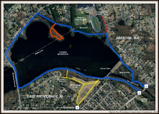
This hike explores the highlights of the lower Ten Mile River from Pawtucket, through East Providence, and into Seekonk. The route of this hike, ironically enough, is about 10 miles and is partly on a bike path, paved neighborhood roads, and trails. It is a one way hike and requires a car-spot. Starting at Doreen Tomlinson Field on Daggett Avenue in Pawtucket, you start this walk by first following the northern most part of the Ten Mile River Greenway Bike Path. The bike path, flanked by post and rail fence, follows the river for a little over three quarters of a mile before coming to Armistice Boulevard. Here, you will see a small dam and waterfall. After crossing the boulevard you are in Slater Park. Soon you will see the one mile marker. Shortly after the marker the bike path makes an abrupt curve to the right and back to the left again. At this point to the right and across the road you can see a pond. A loop around the pond is about a half mile if you choose. In December you will find several Christmas trees decorated here. Just before crossing the road and to the right is the Slater Park Carousel and at the far end of the pond is a bandstand. After you complete the loop of the pond return to the bike path and continue south. To your left the river runs through an area that looks like a canal. These walls were built during the 1930’s by the Works Progress Administration. The bike path then continues south leaving Slater Park, passing under railroad tracks, and soon the first large body of water on the left appears. This is Central Pond and it will remain on your left to the end of the bike path. The southern portion of the bike path crosses into East Providence passing through an old rifle range and former Water Department property before reaching Kimberly Rock Field. Here you want to turn right into the parking lot. A couple hundred feet ahead and on the left is a clearing and a short trail that leads to the adjacent residential neighborhood. The next six tenths of a mile of this hike is on roads. At the end of the trail turn left onto Wildwood Avenue, then right onto Redland Avenue. To the left you can still see Central Pond through the yards. At the end of Redland Avenue, turn left onto Bishop Avenue, and then left once again onto Newman Avenue (Route 152). Be careful here, as traffic is relatively heavy. When you reach Central Pond cross Newman Avenue. The body of water south of Newman Avenue is the Turner Reservoir. You will notice a trailhead just to the right of the reservoir. This is part of the Turner Reservoir Loop Trail. This section of trail follows the shore of the reservoir on one side and the back of a subdivision, with a post and rail fence along the property line, on the other. Soon the trail passes the subdivision and enters a small wooded area. There is a short unmarked trail to the right here that will lead you into the Bridgham Farm Conservation Area. Take it, at the end of the trail turn right and follow that trail to its end. It will come out to a cul-de-sac of the subdivision you just passed. To the left you will notice two things. First, a very large oak tree, said to be over 400 year old known as the Newman Oak. and second, just over the rooftop of the nearby house, you will catch a glimpse of the old windmill that was part of the old farm. After viewing the historic tree and windmill retrace your steps, but instead of turning left back to the reservoir, continue straight. The trail will lead you out to a large open field. This area is what part of the farm was conserved during the 1990’s. Continue straight through the grass field. The trail will slightly turn to the left and lead through the trees back out to the reservoir. Turn right here and follow the earthen embankment towards the Turner Dam. This dam was built in the 1930’s to create the Turner Reservoir as a drinking supply for the City of East Providence. It was used as the primary water supply until the late 1960’s. Continuing you will see a trail to your south that again follows the river. This short stretch of trail will lead you to the parking area along Pleasant Street (Route 114A). From here you want to turn right, then cross the street, and then turn left onto Hunts Mills Road. There is a split in the road, stay left. You will pass the first of two houses on the property. The house is currently boarded up and has seen better days, but there are plans to restore it. The second house, however, is a stunningly beautiful Georgian style home built in the second half of the 1700’s. This is the John Hunt House and it is the current home of the East Providence Historical Society. Just to the right of the house is a gazebo and just to the right of the gazebo is a post with a red trail marker. This is the beginning of the three quarter mile Hunts Mills Trail. The trail first cuts across the north side of the property passing a rather significant sycamore tree before reaching the Ten Mile River once again. Along this stretch there are two rock outcrops to view the river. The first, is somewhat high above the river, is known as Sunset Rock. The second, is by the rivers edge, is known as Otter Rock and received its name by multiple sightings of the river mammal. When the river is running low in the summer months you may catch a glimpse of turn of the century inscriptions on the rock. Continuing to follow the red blazes, you will find yourself in an area that seems abandoned. This is the former Fire Department training grounds. Here there are a couple old tankers and fire tower. There is also a large metal shed. This area is now being leased by the Ten Mile River Watershed Council and they have plans to convert it into a picnic area. Continuing to follow the red blazed trail will lead you to the large grass area behind the Hunt House. There are some informational boards here describing the history of the property. There was once an amusement park here with a carousel. The ring of granite blocks delineates where it once stood. You will next want to pass the gate between the Hunt House and the large stone pump house. Just ahead is the picturesque Hunts Mills Falls. The sounds of the water rushing of the falls makes this a good place to take a break. After taking in the falls for a bit, you will follow Hunts Mills Road back to Pleasant Street, turn right and cross the road once again. You will continue along Pleasant Street crossing the bridge over the Ten Mile River and then through the parking lot. Here is the trail-head to the eastern side of the Turner Reservoir Loop Trail. This section is mostly on boardwalks that cross over the wetlands by the river. Soon you will come back to the earthen dam. The path turns to the left. If you want another view of the waterfall at the dam follow the path, for this hike however, continue straight up the small hill. At the top of the hill you will have a sweeping view of the reservoir. This spot is particularly beautiful during the autumn foliage. To the right the trail continues to follow the edge of the reservoir. This is where you first cross into Seekonk. The trail is now faintly blazed blue and you will follow those blazes to Arcade Avenue with the exception of a few minor detours. Along this trail you will pass the Seekonk High School athletic fields. In the woods to the right you will find a shelter with a stone pillar by it. This is a monument to three Seekonk High School students who lost their lives on the reservoir in 1998. Further along the blue trail, there is a trail that splits to the left and leads out to a peninsula that offers great views of the reservoir in every direction. If you choose to visit either of these sites be sure to return to the blue blazed trail and follow it to Arcade Avenue. After reaching the road, you will have about a mile of road walking. You will want to turn left onto Arcade Avenue, then left onto Newman Avenue. You then need to cross Newman Avenue to get to and follow West Avenue. You will follow West Avenue to the fourth left. This is West River Street and you will turn left here. Turn left again at Reservoir Street and follow it to the end. The asphalt ends and the dirt road turns to the right. On the left is the sign for the Seacuncke Sanctuary and its trail-head. Follow the trail into the sanctuary. It soon splits, stay to the right and you will find yourself on the main trail, known as the Seekonk Trail, that runs along this side of Central Pond. There are other narrower trails that run parallel to this trail. As long as you are going north they all lead to the same spot. The trail then starts to turn slightly to the right and ahead you will see a split. There are two trails here with a gully in between. Both of the trails are blazed blue. The trail to the right will lead you to the majority of the trails of the Gaminno Pond Preserve. For this hike stay to the left. Soon you will be flanked by water. To the left is Coles Brook and to the right is Gaminno Pond. Continuing to follow the blue blazed trail, you will see a mulch covered trail on the left that leads to the Gaminno Pond parking area. Continue ahead a short distance. The blue blazed trail turns to the right. Stay to the left here following an old road that leads up to the Seekonk Meadows and to the parking lot for the Seekonk Library where you left another vehicle. This hike takes about four and half to five hours at a relaxed pace.

TWRI-LTMR-03s

Ten Mile River Greenway Bike Path

TWRI-LTMR-15s

Hunts Mills Falls

TWRI-LTMR-21s

Turner Reservoir

Gammino Pond – Seekonk

  • Gammino Pond Preserve
  • Newman Avenue, Seekonk, MA
  • Trailhead: 41°51’15.63″N, 71°19’43.64″W
  • First Time Hiked: June 29, 2013
  • Last Time Hiked: June 29, 2016
  • Approximate distance hiked: 1.5 miles
  • Easy with some elevation.

Gammino Pond is a man-made pond left over from years of quarrying. It lies behind Seekonk Meadows and is within feet of Central Pond. In recent years the land that surrounds the pond has become preserved for passive recreation. The property features several trails that has been recently blazed by a local Boy Scout Troop. Starting from a small parking area along Newman Avenue across from Division Street is an old access road that leads into the property. This old access road is about two tenths of a mile long and passes a trail to the left that leads to Seekonk Meadows. Turning right at the blue loop trail, it soon starts to swing to the left. Gammino Pond will be to your left and the mouth of Cole’s Brook enters Central Pond on the right. The trail follows a ridge flanked by the two bodies of water for about a quarter of a mile. Start watching for a gully on the left. At the end of the gully the blue blazed trail takes a sharp hairpin turn to the left. The trail ahead, currently not blazed, is part of the Seekonk Trail that crosses into East Providence before connecting to the Seacuncke Sanctuary. After turning left to follow the blue blazed trail a high hill appears on the right. At the top of the hill is a cemetery off of Dexter Avenue. The trail next climbs the rather significant hill and then comes to an intersection. A faint trail to the right that is not blazed leads to Dexter Avenue, the blue loop trail veers to the left, and a white blazed trail leads slightly to the right. Taking the white blazed trail leads you under a thick canopy of trees. The red blazed trail appears on the left. Continue straight along the white trail, it will soon turn to the left and come out to the yellow trail. Turning right, follow the yellow blaze trail downhill as it turns to the left. The yellow trail follows an old service road pass some small fields. About halfway down the trail is a trail on the right that leads to Seekonk Meadows. Continue straight until you see the blue blazes once again. Here you want to turn right, but first continue straight over the small hill and then straight again onto a trail that is not blazed. It will lead you to an area with a sweeping view of the pond. Retrace your steps back over the small hill, turn left, and follow the blue blazes once again. In a little over a tenth of a mile the old access road that you came in will be on the right. Turn here and retrace your steps back to the parking area.

Trail map can be found at: Gammino Pond Preserve.

Fall Fading At Gammino Pond

Fall Fading At Gammino Pond

Seacuncke Sanctuary – Seekonk/East Providence

Seacuncke Sanctuary is a quiet wooded parcel on the east side of Central Pond with occasional clearings of tall grass. In these small clearing you will notice some rather large ant mounds. The sanctuary itself is in Seekonk and the remainder of the land is actually in East Providence. From the small parking area by the trail head sign follow the narrow trail into the sanctuary. Stay to the left at the split and you will soon notice the first of the ant mounds. The trail to the right leads to the Seekonk Trail and you can return on this trail. After staying to the left look for a wood post on the left of the trail. That is the approximate state line. The entrance trail then comes to an end. The trail to the left dead ends at a point that is suitable for kayak or canoe launching. The trail to the right is the Seekonk Trail and follows the shore of Central Pond for about a half mile (mile out and back). The trail ends at the gully and blue trail intersection of Gammino Pond. There are also some narrower less defined trails along this stretch if you care to explore. The property is rather quiet, very peaceful, and good for bird watching.

Trail With Central Pond In The Distance.

Trail With Central Pond In The Distance.

Runnins River Trail – Seekonk

  • Runnins River Trail
  • Taunton Avenue, Seekonk, MA
  • Trailhead: 41°49’43.47″N, 71°19’36.94″W
  • First Time Hiked: April 14, 2014
  • Last Time Hiked: January 15, 2017
  • Approximate distance hiked: 1.5 miles
  • Easy

Starting from behind the Newman YMCA at a small parking area, there is a dirt access road to the camp area of the YMCA. A few feet ahead is the beginning of the three quarter mile long Runnins River Trail. The trail has three very distinctively different portions to it. The first section that passes behind the fire station and town hall is a stone dust trail that is ADA compliant. The trail then passes over marsh areas and wetlands via a series of boardwalks before coming to a bridge that crosses the Runnins River. Beyond the bridge the trail becomes much more natural as the footing is comprised of soil and roots. The trail, blazed red, ends at Arcade Avenue. There are two smaller trails here as well. The newly improved yellow blazed Town Hall Trail which ends at the town hall parking lot (another parking option) and a blue blazed loop trail. Nonetheless, being a very short hike, it is indeed well worth checking out. By following Arcade Avenue north, then Ledge Road west, you can walk to the Turner Reservoir Loop for additional mileage.

Trail map can be found at: Runnins River.

Runnins River Trail

Runnins River Trail

Seekonk Meadows – Seekonk

Seekonk Meadows lies next to the Seekonk Library along Newman Avenue. The small park, built on a capped landfill, has a handful of walking paths that total just about a half mile. The park features fields of wildflowers, a gazebo, and a war memorial. It also abuts the Gaminno Pond property which has more trails to explore.

Here is a link with some information: Seekonk Meadows

twri-smead16

Gazebo at Seekonk Meadows

Turner Reservoir – East Providence/Seekonk

  • Turner Reservoir
  • Pleasant Street, East Providence, RI
  • Trailhead: 41°49’48.68″N, 71°20’39.48″W
  • First Time Hiked: June 2, 2013
  • Last Time Hiked: September 26, 2021 
  • Approximate distance hiked: 2.7 miles
  • Easy.


June 2023 – Please use caution while hiking the Turner Reservoir Loop Trail due to bridge construction. The bridge is open and the loop can be completed, however, the sidewalks on the bridge are still under construction.

The Turner Reservoir was flooded in the 1930’s and supplied drinking water to the residents of East Providence for several years. Today the reservoir is used for passive recreation. There is also a 2.7 mile loop around the reservoir and Ten Mile River that is mostly a wooded trail, but includes boardwalks and some road walking. There is a parking lot along Pleasant Street opposite Hunts Mills that has an informational board about the trail and its surroundings. Following the dirt trail along the west side of the Ten Mile River you will soon come to a grassy area near the Turner Dam. Continue to follow the grassy shore of the reservoir to a trail the leads into the woods. This section of trail is rather narrow as it follows the shore of the reservoir behind a residential neighborhood before coming to Newman Avenue. Here you turn right (being aware of traffic) and cross the causeway between the Turner Reservoir and Central Pond. Here you cross into Seekonk and then right onto Arcade Avenue. Just north of utility pole 1416 a blue blazed trail into the woods appears. This long stretch of trail follows the shores of the reservoir once again passing behind the Seekonk High School. Along the way there is a side trail that dead ends onto a peninsula that has sweeping views of the reservoir. The wooded trail ends back at the earthen dam where there are some more sweeping views of the reservoir. From here, walk down the hill and the loop continues along a series of boardwalks that wind through the wetlands along the river. The trail then ends at another parking area along Pleasant Street. Turn right and cross the bridge over the Ten Mile River to reach the first parking area.

Trail map can be found at: Turner Reservoir.

Reservoir Panoramic

Reservoir Panoramic

turner-bridgham-color-gis

Turner Reservoir/Bridgham Farm Color Map (2017)

Martin Wildlfe Refuge – Seekonk

  • Martin Wildlife Refuge
  • Fall River Avenue, Seekonk, MA
  • Trailhead: 41°49’3.10″N, 71°20’16.08″W
  • First Time Hiked: April 16, 2013
  • Last Time Hiked: August 25, 2016
  • Approximate distance hiked: 0.7 miles
  • Easy.
 

Martin Wildlife Refuge is owned by the Seekonk Land Conservation Trust. There is a nice and short, but picturesque, loop trail here that skirts the shores of Burr Pond. The pond is part of the Runnins River that flows south into Hundred Acre Cove. The trail is well defined and there is a short crossover trail. A trail map can be found at the kiosk at the parking area.

Burr Pond

Burr Pond

Caratunk – Seekonk

  • Caratunk Wildlife Refuge
  • Brown Avenue, Seekonk, MA
  • Trailhead: 41°52’26.71″N, 71°19’18.50″W
  • First Time Hiked: January 5, 2013
  • Last Time Hiked: November 15, 2021
  • Approximate distance hiked: 3.0 miles
  • Easy with slight elevation.


Although in Massachusetts, Caratunk Wildlife Refuge is a Audubon Society of Rhode Island property.  The property offers several features including a couple small ponds, bogs, fields of wildflowers, hemlock grove, and large boulders. From the parking lot turn left after the barn and pass through a open field along the red trail.  At the next intersection, the short red trail goes to the right.  Stay to the left and follow the trail pass the beginning of the blue trail to a trail that loops around Muskrat Pond.  After looping around the pond go left onto a trail that leads to the blue trail.  Follow the blue trail for a bit where you will cross Coles Brook by the Ice Pond.  Take note of the granite bridge. Coles Brook winds through the property and eventually flows into the Ten Mile River downstream. From here follow the blue blazed trail under the power lines and explore the back section of the property. There are several trails on the backside forming two loops. The trails here pass through bogs and stands of beeches and hemlocks. After exploring the blue trails make your way back to the yellow trail and follow it to Monument Rock, a very large boulder that is about ten feet high. From here make your way to the Boulder Train, and cross a bridge over a stream at the end of the trail where it meets the red trail.  At this intersection turn left onto the red trail through the pine woods and eventually back to the parking lot. Trail maps are available at the barn by the parking area.

More info & trail map can be found at: Caratunk Trail Map

Cole's Brook

Cole’s Brook