Block Island North – New Shoreham
- Block Island North
- Corn Neck Road, New Shoreham, RI
- Trailhead: 41°12’48.58″N, 71°34’1.12″W (3.2 miles from ferry)
- Last Time Hiked: May 14, 2016
- Approximate distance hiked: 6.0 miles
- Moderate with areas of difficulty.
Block Island is 14 miles off the Rhode Island mainland coast. It is a bustling resort town in the summer months and host to only about 1000 folks during the brutal New England winters. New Shoreham (the one and only town on the island) is in fact the smallest town in Rhode Island by both area and “year round” population. Conservation on the island has been outstanding. Over 43% of the island is under some sort of conservation protection by several different organizations. For this hike, I covered a large portion of the northern end of the island. Parking at the Hodge Family Wildlife Preserve entrance, I first made my way toward Middle Pond following the main trail in the Hodge Preserve. The trail is grass mowed that traverses up and over several rolling hills of meadows before ending at the shore of Middle Pond. Along the trail there are sweeping views over the pond and Block Island Sound including the North Light at the tip of the island. From here I retraced my steps back to the parking area opting to follow the spur loop trails. Once back out to Corn Neck Road I turned right and followed the road south until I came to Clay Head Trail (just after the red house, number 728). The road, marked with a post, is a dirt road that leads to the parking area for the Clay Head Nature Trail. There are several private roads off of this road. Be sure to continue straight until you reach the trail head. From here the trail winds narrowly over meadow covered hills and wooded areas before reaching boardwalks near the Clay Head Swamp on the right. Shortly after the swamp the trail turns abruptly to the left and starts to climb upward, but first check out the beach and the massive clay bluffs. Continuing the trail climbs uphill and parallels the bluffs occasionally popping out to the edge. Exercise extreme caution along the edges. The views of Block Island Sound are quite impressive from the top of the bluffs. The trail passes through areas of shrubs and trees, with an abundance of birds, passing two small ponds to the left. There are also several spur trails to the left that lead into “The Maze”. If you opt to explore be sure to have a GPS device with you. For this hike, I followed the Clay Head Trail to its end. At the four way intersection, continue straight. Shortly thereafter the trail comes to a dirt road. Following the road to north you soon come to an intersection, turn left here and follow the road out to the paved Corn Neck Road. Turning right I followed the road to its end at Settlers Rock passing Sachem Pond on the left. The rock is a memorial to the original settlers and purchasers of the island back in 1661. From here the walking gets tough. If the hills of Clay Head have not already done a number on your muscles, the sands of the beach will. From Settlers Rock to the iconic North Light and back is all beach walking in soft sand through the Block Island National Wildlife Refuge. It is well worth the walk though. The light, built in 1867, is now owned by the town and is home to a museum (open seasonably). At the time of this hike I came upon several nesting seagulls. After spending a little time here I made my way back to Settlers Rock and then southerly along Corn Neck Road. On the left at a stone wall you will see a set of wooden stairs. If you opt to, this is the Atwood Overlook. From the top of the hill you can look back towards the North Light. A little further up the road on the right is the Labyrinth, again the entrance is a set of wood stairs over a stone wall. This unique spot is a somewhat spiral path, similar to a maze, but with no dead ends, that leads to the center. It is said to be sacred. After spending a few moments here, I made my way back to the road continuing south back to the Hodge Preserve parking area. I came across an abundance of birds along this 6 mile trek and ran into a few fellow hikers.

Meadow at Hodge Preserve
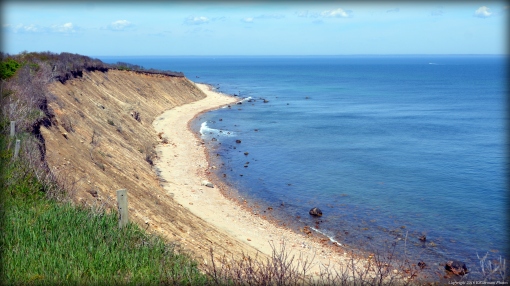
Clay Head Bluffs

Block Island North Light
