Posts Tagged ‘ Big River Management Area ’

Carr River – West Greenwich

  • Carr River – Big River Management Area
  • Hopkins Hill Road, West Greenwich, RI
  • Trailhead:  41°37’51.90″N, 71°34’16.59″W
  • Last Time Hiked: August 8, 2020
  • Approximate distance hiked: 1.7 miles
  • Fairly easy with some elevation.

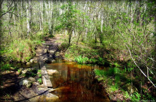
As with most hikes at Big River, be sure to have a map and/or GPS. This hike partly on each side of Hopkins Hill Road follows trails less used. Starting from the large parking area for Tarbox Pond and Carr Pond hikes follow the trail to the left into the property. The trail starts a long descent downhill. There is a spur trail to the left. Ignore it and continue straight ahead to the (next) four way intersection. Here you will turn left and continue straight to Hopkins Hill Road. There will be a couple spur trails and intersections along the way. Ignore them all. When you reach the road, follow it downhill to the pond. Tarbox Pond is flanked by pine trees as it stretches to the east. In the summer months the small coves along the pond will be filled with lily pads. Across the street is a wooden guard rail. Directly to the left of it is a narrow trail-head. This is where you will go to continue this hike. Be careful crossing the street here as there is bit of a blind spot. Once on the trail you will notice a narrow river to the right and down the bank. The trail splits, stay to the right as the trail descends downhill once again. The trail widens a bit then bends to the left. The trail traverses through a forest floor of ferns as it continues ahead. To the right you will catch glimpses of tall dead trees in a swamp. This is the Carr River. Soon you will pass two trails to the left. Make note of the second one, this will be used on your exit. The trail then turns slightly to the left. Just ahead you will see a pile of debris that was used to block a former trail. At this point and on the right is a very narrow (almost non-existent) trail that climbs up a small knoll. It dead ends at the end of the peninsula surrounded by the swamps of the Carr River. This is a great and secluded spot to sit on a fallen tree and take in nature for a few moments. From here retrace your steps the “second left” now on your right. Follow this trail as it climbs uphill and bears to the right joining the main trail that climbs uphill. You will pass two four way intersections (not very far apart). Continue ahead and at the next major intersection turn left. This trail (sometimes referred to as the Big River Expressway) will lead you back to Hopkins Hill Road directly across from the parking area. Make note that hunting is allowed here.

Trail Map: Carr River

TWRI-CR2006

Carr River From The Knoll

Mud Bottom Brook – West Greenwich

  • Mud Bottom Brook – Big River Management Area
  • New London Turnpike, West Greenwich, RI
  • Trailhead:  41°37’4.38″N, 71°35’46.70″W
  • Last Time Hiked: May 16, 2020
  • Approximate distance hiked: 4.5 miles
  • Moderate, navigation can be difficult.


First and foremost, I would advise not to attempt this hike without a map, GPS tracking, good sense of direction, or all of the above. I personally have ventured into Big River enough times to feel comfortable enough to wander its many, many, many trails. To say Big River has a vast network of trails is a gross understatement. For this hike I took a wrong turn along the way and found myself on a trail that was not on the Great Swamp Press map and found myself relying on GPS tracking and my internal compass to make my way back to a main trail. (My guest did a great job at remaining calm!!) With that being said, I am going to attempt to recall my route, but please don’t rely on this post alone if you attempt this hike. From the parking area at the end of New London Turnpike by the Wincheck Gun Club we passed the gate and followed the pine tree flanked dirt road for about four tenths of a mile. Turning left the trail then winds downhill to its end. Here we turned right onto a trail called Sweet Sawmill Road. This trail climbs slightly uphill passing some stone walls on the right. At the next intersection we turned left and followed that trail just under a half mile to its end. The trail widens at its end, stay to the right here. The trail then declines slightly into the valley that Mud Bottom Brook runs through. Along the way, after a heavy rain, you may encounter some large puddles along this trail. At the next intersection stay to the right and again right a little further down the trail. This trail will lead you to the crossing at Mud Bottom Brook. There is a wobbly plank and stones here to make the crossing easy. From here we continue ahead until we came to a “T” intersection. The trail in both directions at the time of this hike was blazed blue. The blazes are amateur and not by any means the type of blazes seen at Arcadia. We turned left here and still feeling confident we were on the right track and started to follow the blue blazes. At the next intersection is where I suspect the plan went out the window. We came to the intersection realizing it was not on the map. Thinking we might have been a little further north, I suspected the trail to the left might be the second crossing of Mud Bottom Brook. We turned right here thinking it would continue along the edges of the peninsula are eventually turn south paralleling  the Carr River. It did not! (I do not actually know where the trail to left leads, that will be a hike for another day). After turning right we soon came to another intersection, again blue blazed. We turned right and followed it nearly a mile up and down hills, zigzagging back and forth to its end. This stretch was actually quite pretty. We passed stone walls, a rather large natural looking swale, and hunting stand along the way. At the intersection at the end of the trail blue blazes go to the right. Using the internal compass at this point we turned left and then almost immediately left again and then right just up ahead. The trail we were on would lead us back to the New London Turnpike trail. Turning right onto the sandy road it veers slightly to the right before curving to the left and straightening out. Ahead the sandy road splits again. Stay to the left here. This is the trail back to the parking area just under a mile away. The remainder of the walk climbs slightly uphill along the wide New London Turnpike. Be sure to wear orange here during hunting season.


Map can be found at: Mud Bottom Brook.

TWRI-MBB08

The Crossing At Mud Bottom Brook

Big River Quarry – West Greenwich

  • Big River Quarry _ Big River Management Area
  • Division Road, West Greenwich, RI
  • Trailhead:  41°38’56.62″N, 71°34’27.20″W
  • Last Time Hiked: May 9, 2020
  • Approximate distance hiked: 2.2 miles
  • Fairly easy.


This hike follows the perimeter of Rhode Islands Desert. Yes! Desert! This part of Big River is actually an abandoned quarry and gravel pit with large areas of sand, dunes, and pine trees. With all of Big River, there are no blazed trails here and there are plenty of side trails. For this hike, I followed the “trail” that currently appears on Google Maps and the Map My Hike app. To access it follow the gravel road into Big River from Division Road. There will be three paths to the right. The first is quite narrow, the second much more defined, and the third is just as defined. Ignore the first two and turn right at the third. This will lead you to the “trail” on the app. For almost the remainder of this hike you will follow the trail on the app. If you are not using an app, this is a great place to wander around, keeping tree lines of  the perimeter as a basic guide to the hike. Following the trail, you will first come upon a pond before winding through areas of pine trees. You will catch glimpses of the dunes along the way. As the trail reaches its western extent it turns to the south and then through an area of low shrubs and grass. Back and forth through the pines, the trail then turns and follows the eastern edge of the desert. Near the end of the trail just before it turns onto Hopkins Hill Road turn left and follow the path downhill to the gravel road you entered on. Turn right here and follow back to the parking area.

TWRI-BRQ07

Rhode Island’s Desert

Capwell Mill Pond – West Greenwich

  • Capwell Mill Pond – Big River Management Area
  • Burnt Sawmill Road, West Greenwich, RI
  • Trailhead:  41°38’39.57″N, 71°36’27.08″W
  • Last Time Hiked: April 17, 2018
  • Approximate distance hiked: 2.7 miles
  • Fairly easy with some difficult navigation.


This is yet another beautiful hike in the Big River Management Area. The trails here are numerous, unmarked, and can be difficult to navigate. With that being said, it is not advisable to do this hike without a reliable map, an understanding how to read it, a sense of direction, and absolutely be sure to use GPS tracking in the case you need to back track. This hike starts from a small parking area along Burnt Swamp Road before the gate by the Capwell Mill Pond Dam. It is about three tenths of a mile from Nooseneck Hill Road. After passing the gate you will see the dam on the left. Shortly after the dam follow the narrow trail to the left. It climbs slightly uphill into a grass field before winding into the tall pines. Soon a trail comes in from the right. Stay to the left here and you will cross a bridge. The view, overlooking a tributary of the pond is quite pleasant. After the bridge the trail splits, continue straight. The trail slowly climbs uphill through a lush forest of pines. Be aware of your trail intersections for this walk. At the next trail intersection continue straight again following the main trail. You will continue to climb slightly uphill. This section of trail can be quite wet after a heavy rain. You will soon pass a stone wall. Just after the wall is a narrow path to the left. Ignore it for this hike and continue ahead. You will soon pass a second stone wall and then the trail winds a bit before coming to a large boulder at a trail intersection. This is about the one mile mark. Ignore the trail to left and continue straight on the main trail as it starts to bend to the right. Slow down and start looking for the next trail intersection about one tenth of a mile after the large boulder. As the trail starts to turn to the right by a mossy rock with a tree growing on it there is a trail on the left. It is narrow, but defined enough to be noticed. Turn left here and follow the trail as it starts downhill. Soon the trail ends at another well defined trail. There will be a white blaze on the tree at the intersection. Turn left here. In a few yards you will come to another intersection with a tree blazed white. You will want to continue straight, but first follow the trail to the right to the bridge crossing the stream called Mud Bottom Brook. The slight detour is well worth it. Take a moment here. The babbling brook drowns out all other nearby sounds and you are out in the middle of nowhere nearly a mile from any civilization. Return up the hill to the tree with the white blazes and turn right. After making the turn and following the trail you will pass a stone wall on the left. The stone wall then flanks the trail to the right for a bit before the trail starts to descend downhill leaving the stone wall behind. The trail then starts its slight bend to the left passing a boulder in the middle of the trail. The boulder is a good reference point and is just the right height to sit for a moment and take in the nature around you. From here the trail continues downhill and bending to the left. You will start getting your first glimpses of the pond through the trees on the right. Passing another stone wall the trail splits. They rejoin in a few yards where the trail splits yet again. At this split stay to the right. There is also some mountain laurel scattered around in the area. Continuing ahead the pond is still to the right through the trees and there is another stone wall on the left. The trail turns to the left crossing the stone wall and then to the right meandering to and from the pond. A trail soon comes in from the left, stay to the right and continue to the end of the trail. Turn right and you will cross the bridge overlooking the tributary of the pond once again. Just after the bridge turn right onto the trail that will lead you back to the dam and parking area. Blaze orange is required during hunting season.


Map can be found at: Capwell Mill Pond (Map 1), (Map 2).

TWRI-Capwell02

Pines, Stone Walls, And The Pond.

Hell’s Half Acre – West Greenwich

  • Hell’s Half Acre – Big River Management Area
  • Congdon Mill Road, West Greenwich, RI
  • Trailhead: 41°36’42.98″N, 71°37’20.15″W
  • Last Time Hiked: October 29, 2017
  • Approximate distance hiked: 4.3 miles
  • Moderate, some hills, can be difficult to navigate.


The New London Turnpike was once the main thoroughfare between Providence and New London. The road, nearly straight for miles, was scattered with small villages along its route. At the intersection of Congdon Mill Road was one of these small villages. As railroads and public roads were built, the once very heavily traveled toll road became nearly obsolete. Now off the beaten path, this one in particular village became a haven for gambling, prostitution, and an occasional murder earning its name Hell’s Half Acre. Today nothing remains of it except an old cellar hole here and there, if you can find them in the growth of young pine trees. For this hike, covering a large portion of the southern parts of the Big River Management Area, we started at the parking area along Congdon Mill Road just east of the Congdon River. The old dirt road leaves the parking area in a northeasterly direction. Immediately we saw a great blue heron fly overhead as we were starting our hike. After going downhill a bit the road splits. Here we turned right following a rocky trail uphill. Soon there is a spur trail to the left that leads downhill to a small pond. We checked it out and then returned to the trail we were on, continuing uphill, soon overlooking valleys below. Along the way you will come to a property marker to your left. It appears to read “RA 1885”. Ahead is a dip in the trail as it descends quickly down before climbing rapidly back uphill. There is a split in the trail here as well. Stay to the left and at the top of the hill turn to the left following the most defined trail. You will soon come to a “faint” trail intersection. Continue to follow the well defined trail here. A little further ahead is yet another trail intersection. Turn left here and stay to the left as the path widens into another well defined trail. The hardest part of the navigation is now behind you. If you have taken all the proper turns you will soon be following the top of a hill with a deep valley to your left. It was around this area we caught a glimpse of a deer leaping through the woods. At the next trail intersection we stayed to the right making our way to another intersection where we stayed to the left as the trail descends downhill towards  Hells Half Acre. You will notice that the forest floor is now covered with a dense growth of young pines. When you approach the next intersection stay to the left again. Here the trail loops near the intersection. The growth of the pine trees covers what cellar holes may be here. There is no evidence of the village whatsoever along the trail. But when the late October wind kicked up every so gently, we could here the laughter of young women, drunk men, and a tavern piano playing. The trail then winds to the north soon crossing a rickety old bridge that spans a small brook. The trail then comes to another intersection. Look over your left shoulder, there should be a sign that says “Buck Run”. At the intersection stay to the left. Ahead, and unfortunely, there is evidence of humans. There is a small section of trail that is littered with trash from yesteryear. The remainder of this trail offers stone walls and an occasional boulder. Continue straight passing a trail coming in from the right and a trail that is on the left. Soon you will come to a intersection of old dirt roads. Turn left here, onto Sweet Sawmill Road, a well defined trail that you will follow straight back to the parking area. The old dirt road soon becomes flanked by stone walls and passes open fields where pheasant hunters can be found. Continuing straight you will pass an old wooden “Regulations” sign and cross a small stream once again before ending the hike at the parking area. Big River is notoriously known for its web and mazes of unmarked trails. It is highly recommended to not only obtain a map of the property but use a GPS tracking device while hiking here. This hike is fairly easy with some hills, but navigation can be difficult and one could easily get lost here. Also, this area is used by hunters. Be sure to wear blaze orange during hunting season.


Map can be found at: Hell’s Half Acre (courtesy of Auntie Beak).

TWRI-HELLS02

Pine Grove by Hell’s Half Acre


Big River – West Greenwich

  • Big River – Big River Management Area
  • Nooseneck Hill Road, West Greenwich, RI
  • Trailhead: 41°38’53.88″N, 71°36’25.88″W
  • Last Time Hiked: May 27, 2017
  • Approximate distance hiked: 5.4 miles
  • Moderate, Difficult navigation without map or GPS.

In the 1960’s several local residents were forced to leave their homes here in the area of Big River. The State took the land by eminent domain to build a reservoir. The reservoir, first planned in the 1920’s, was never built and today the large and sprawling property is considered open space with a maze of trails, small streams, ponds, and cellar holes. With that being said, as with all of the Big River property, it is suggested not to wander here without a map, GPS device, or someone who knows the property well. For today’s hike we were led by Sandi of the Appalachian Mountain Club who guided us through the heart of Big River on a nearly five and a half mile trek. Her knowledge of not just the trails, but the history of the property is astounding. I would highly suggest keeping an eye out for any future hikes she may lead here. We started from the main parking area along Nooseneck Hill Road (a quarter mile south of Route 95). From here we followed Burnt Sawmill Road into the Management Area along the paved road until we reached a gate. The pond, with dam and waterfall, on the left is Capwell Mill Pond, fed by both the Carr River and Mud Bottom Brook. Continuing along Burnt Sawmill Road, we were flanked by old trees and telephone poles. At pole 24 a trail, an old cart path, veers to the left. We took it following the old cart path through pine groves and maples before crossing a stream at a wooden bridge that has seen better days. The trails continues, climbing a small hill, passing a couple of stone walls, and a few young pines on the forest floor below the towering ones. The trail splits and narrows, here we stayed to the right and soon came to another trail intersection where we stayed to the right once again. At the next intersection we stayed to the left slightly and then continued straight. The trail to the right would lead you back to Burnt Sawmill Road. Continuing ahead we came to a cellar hole and well on the left. It is not easy to see from the trail and if you do find it, be sure to use caution by the well. The next highlight of the hike comes up on the right. It is the Sweet Family Cemetery with graves dating back to the 1750’s. The trail then passes through another pine grove. This one is quite noticeable as the trees have grown very densely close to each other. Soon after there is a spur trail on the right that leads to the dam on the north end of Sweet Pond. The dam is now breached, intentionally, and Sweet Pond is no more. It is now just a stream through a grass filled basin. Retracing steps back along the spur trail we then turned right, southerly, along the trail we were previously on. Next we came to Sweet Sawmill Road, another old road. Here we turned right and soon passed the south side of the remnants of Sweet Pond. This stretch is flanked by some stone walls and ferns. At the next intersection, a four way, continue straight ahead. A few hundred feet ahead at the next intersection turn right. This is Burnt Sawmill Road once again. Following this road to its end will lead you back to the parking area. Along the way we would come across another cemetery and a former homestead with the only evidence left being a tire swing. Before concluding our hike we did explore a trail to the right that led to a stream that flows between the former Sweet Pond and Capwell Mill Pond. Wildlife is abundant here as it is not uncommon to see deer, coyote, squirrels, chipmunks, and turtles. The property also is carpeted by ferns and wildflowers with birdfoot violet and wild geranium being in bloom at the time of this hike. This is a popular hunting location as well. Orange is mandatory during hunting season.

Trail map can be found at: Big River (courtesy of Auntie Beak)

TWRI-BRiv07

Sweet Sawmill Road

TWRI-BRiv02

Dam and Waterfall at Capwell Mill Pond

Reynolds Pond – West Greenwich

  • Reynolds Pond – Big River Management Area
  • Fish Hill Road, West Greenwich, RI
  • Trailhead: 41°39’35.06″N, 71°37’41.94″W
  • Last Time Hiked: June 16, 2016
  • Approximate distance hiked: 2.6 miles
  • Fairly easy.


I have been exploring lesser known areas of the State Management Areas the last couple of hikes and I am convinced that the wildlife are quite content with being in these areas. Being mid to late afternoon I was surprised to run into deer. Not just one, but several. And furthermore, they didn’t seem to concerned of my presence. For this hike I followed a trail into the Big River Management Area from the bend on Fish Hill Road. Following the trail south I passed a sandy area to the left while making my way to the first split in the road. Here I turned left and then continued straight passing a cart path to the right. With a map in hand I intended to loop the pond, but soon found that the pond had overflowed onto the trail. At the time of this hike it was impassable. So after a quick peak at both Reynolds Pond and Big River I retraced my steps back to the last intersection. Here I turned left and followed the cartpath for a bit before making another left. This trail leads down to the southern side of Reynolds Pond via a trail that runs along Big River. Soon I was just shy of the spot I was before that was overflowed. From here I retraced my steps back to the car. Besides deer, I saw turtles, chipmunks, various birds, and kayakers!! It is highly suggestible to obtain a copy of the Great Swamp Press map of Big River before making your way into the area.

TWRI-Reynolds01

Reynolds Pond

Tarbox Pond – West Greenwich


This would be my third excursion into the Big River Management Area. Last summer I had hiked Carr Pond and Hungry Hill on this property. As with all of Big River a map is a must and GPS is highly recommended as there is a tremendous maze of unmarked trails here. With that being said I began this hike with my Great Swamp Press map in hand from a parking area on Hopkins Hill Road. Two trails lead away from the parking area. I took the one to the left. (The one to the right will take you to Carr Pond). I followed this trail downhill first overshooting the turn I should’ve taken at the first major intersection. You should turn right at the first major intersection (currently marked with orange flagging). I then followed this trail and it veered left to a stream crossing followed by a small hill with another stream crossing on the opposite side before reaching a very large rock outcrop. At the outcrop there was a very large “camping” area with makeshift benches and fire pit. A marking in a tree called off the stop as Indian Rock. I then followed a narrow path off to the left that followed the edge of a peninsula before winding back to a wider dirt road. At the road I turned left and followed it nearly to its end. I then turned right at what appeared to be a T intersection with a trail leading off to the right and uphill. After crossing the top of the hill the trail descended to its end onto the abandoned portion of the New London Turnpike. At the turnpike I turned left crossing an overflowing area of marsh before turning left at the next trail. Along this trail I came across an old brick building with some very positive graffiti scrolled across the facade. At the end of this trail I turned left onto the next trail keeping the marsh in sight. Toward the end of this trail a vast network of minor trails meander in and out of the area. I found myself following the trails closest to the marsh and pond while heading in a westerly direction. There were many great sights in this area including some handy work by beavers as well as their dams. There were also some spots with wide open views of the pond and marsh. I also came across a pair of ducks in flight (who apparently knew I was trying to capture a photo of them… I failed!). This area is well worth exploring but be sure to keep your bearings. I eventually made my way back to Hopkins Hill Road via small trails following the edge of the pond. At the road I turned left over a small dam and then left again onto a trail that led back into the woods. I followed this trail to the second intersection (after a stone wall). At this point I turned right and uphill back to the parking area. Keep in mind this area is open to hunting and orange should be worn during hunting season.


Trail map can be found at: Tarbox Pond.

Flooded Marsh

Flooded Marsh

Carr Pond – West Greenwich

  • Carr Pond – Big River Management Area
  • Hopkins Hill Road, West Greenwich, RI
  • Trailhead: 41°37’51.32″N, 71°34’16.41″W
  • First Time Hiked: August 2, 2013
  • Last Time Hiked: October 10, 2020
  • Approximate distance hiked: 3.7 miles
  • Easy with slight elevation

Starting from a parking area on Hopkins Hill Road take the trail to the right into the woods. The path descends down toward the pond first passing an old rusty car, crossing another main trail, and then through an area of swamp before reaching the main loop trail. The path generally goes straight towards the pond. Do make note of where you made any turns so you can retrace your way back to the parking area. The main loop is a wide trail much like a cart path. When you reach the main loop trail follow it to the left. The loop, an old dirt road, is well traveled and quite wide. You will want to follow this around the pond. There are several paths and trails leading away from the pond to the left of the main trail. I would advise not to wander too far without a map or a GPS device on these trails. Big River has an immense network of unmarked trails. The paths leading to the right of the main trail lead to areas overlooking and along the shores of the pond. Some even lead to small beaches. (No swimming allowed here). The views of the pond at these trails are spectacular. After checking some of these trails continue along the main trail Towards the end of your loop you will come upon an old pump house and a raised pipeline. From here complete the loop and look for the trail where you came in from. Follow the trail(s) back uphill to the parking area.

Trail map can be found at: Carr Pond

Along The Ponds Edge

Along The Ponds Edge

On The Trail

On The Trail

Hungry Hill – Coventry/West Greenwich

  • Hungry Hill – Big River Management Area
  • Harkney Hill Road, Coventry, RI
  • Trailhead: 41°39’54.21″N, 71°37’7.17″W
  • Last Time Hiked: July 12, 2013
  • Approximate distance hiked: 2.9 miles
  • Easy with slight elevation.


This was my first venture into the Big River Management Area. I had bought a Great Swamp Press map of the management area a while back and found several potential hikes. Hungry Hill seemed to be a good start. Starting from the parking lot at Zeke’s Bridge Fishing Area I crossed Harkney Hill Road to the beginning of the trail next to utility pole #36. Following the trail into the woods I took a left at the first split and started the climb up the hill. The trail to the right I would return on. Continuing up the hill there are a couple trails to each side. I continued straight until the trail ended at a “T” intersection. At this point you are about a half mile in and most of the significant climb is done. I then followed the trail to the right heading in a southerly direction. This is the higher trail of the two main trails. This is a long and peaceful wooded section of trail with the summit of Hungry Hill to your left. (There is no actual trail to the top of the hill.) As you approach the end of the trail you can start to hear the buzz of traffic. Interstate 95 is ahead. At the end of the trail is another “T” intersection. I turned right going downhill for a rather short distance, then right at the bottom of the hill heading now in a northerly direction along the lower trail. This trail continues downhill and toward Big River. There are some rather low and muddy spots along the way after a rainy day and can be buggy. There are a couple of loop trails to the left off the main trail that bring you to the rivers edge. Unfortunately, I did come across some areas of trash and litter on the lower trail, but that aside, this was a nice walk. Continuing north along the lower trail I came to the first split and then retraced my steps along the entrance trail and back to the car. I did come across several frogs here. I did not see the bear that was spotted in this area last week.

Trail map can be found at: Hungry Hill

A Trail At Hungry Hill

A Trail At Hungry Hill

Big River

Big River