- Lantern Hill
- Wintechog Hill Road, North Stonington, CT
- Trailhead: 41°28’0.82″N, 71°56’44.18″W
- Last Time Hiked: April 17, 2017
- Approximate distance hiked: 1.9 miles
- Difficult to Strenuous With Some Climbing.
Lantern Hill is a must visit if you are in the southeastern corner of Connecticut. The hike described here climbs over Lantern Hill just southeast of the Foxwoods Casino complex and follows the Narragansett Trail. Starting from a makeshift parking area (with no signage) along Wintechog Hill Road the light blue blazed trail immediately begins to climb the hill following an old cartpath. After a couple hundred feet the trail levels off for a bit before coming to a red blazed Lantern Hill Loop Trail. Be sure to be aware of the blue blazes of the Narragansett Trail when you approach trail intersections. You will want to follow them and not the red blazes for this hike. The Narragansett Trail then starts to steadily climb the hill once again. The inclines are quite impressive at times. The trail first overlooks the Pequot Reservation to the north and west offering views of the casino and Lantern Hill Pond below. The trail then climbs over the summit to a stunning overlook with miles and miles of sights to the east and south. Clear days will offer a view of the Atlantic Ocean to the south. It is also interesting to see the hawks and vultures soaring through the sky sometimes below you. Use extreme caution along the edges here as a fall would surely be fatal. Also here on the first day of Spring the Westerly Morris Men climb the hill for their annual sunrise dance at the summit. The hill got its name from the War of 1812 as the hill was used as a lookout. When the British were spotted approaching, barrels of tar were ignited to warn nearby residents. After spending some time at the summit continue following the blue blazed trail as it winds, at times steeply, down the hill. There is one section, that we dubbed the Lemon Squeeze, that will challenge your footing, balance, and upper body strength. The trail then traverses the south side of the hill passing through groves of mountain laurel before coming out to the North Stonington Transfer Station. Again, be sure to pay attention to blazes and turns at intersections. After the Dog Pound the trail turns to the left through the transfer station and out to the road. At this point you have hiked 1.4 miles of the Narragansett Trail. The trail continues ahead, however it is closed (from Wintechog Hill Road to Route 2) at the moment because of logging. For this hike turn left and follow Wintechog Hill Road about a half mile back to the parking area.
Trail maps can be found at: Lantern Hill
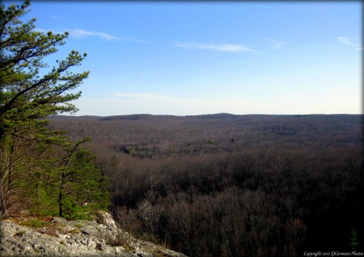
The View At The Top Of Lantern Hill.

