Posts Tagged ‘ Dog Friendly ’

North Attleboro Town Forest – North Attleboro

  • North Attleboro Town Forest/Bragg And MacDonald Memorial Forest
  • Plain Street, North Attleborough, MA
  • Trailhead:  42° 0’27.05″N, 71°17’42.07″W
  • Last Time Hiked: October 21, 2022
  • Approximate distance hiked: 1.7 miles
  • Easy.

The North Attleboro Town Forest is known for its dog parks more so than its trails, however, the trails here are quite nice (and used mostly by dog walkers). Coming in from the main entrance just to the left of the dog parks you will come to a trail intersection. For this hike, I decided to do the green blazed perimeter trail to see the most of the property. Turning left onto the loop trail you will find yourself in a tunnel of towering pines. The trail is soft from fallen pine needles. The trail turns to the north and then east. Pines are still quite prevalent, however, oaks and maples start to join into the mix. The forest floor also now has a covering of low laying shrubs. The trail turns south and then west coming back to the back side of the dog park. The trails are marked with blazes on posts at each intersection.

Trail map can be found at: North Attleboro Town Forest

TWRI-NATF00

Morning Sun On An Autumn Morning

Almy Reservoir – Johnston

  • Almy Reservoir
  • Reservoir Avenue, Johnston, RI
  • Trailhead:  41°48’56.50″N, 71°31’43.92″W
  • Last Time Hiked: December 12, 2020
  • Approximate distance hiked: 2.6 miles
  • Fairly easy with some elevation, crossing at brooks can be difficult.

Wood Lake Park is host to several ball fields, a playground, and a dog park. Behind it are a network of trails that are on land owned by both the Town of Johnston and the Johnston Land Trust. Park by field 4 and walk up the access road to the dog park. Cut through the dog park to access the trail head. The trail turns slightly to the north and comes to a four way intersection. The trail to the left leads back to the backside of the ball field. The trail to the right will lead you to both the reservoir and another trail that reaches into the southern end of the property both which dead end. The trail straight ahead will lead you to Dry Brook, which coincidentally is not so dry after some rain. After crossing the brook there is a small maze of trails that lead to a peninsula and a small loop that brings you to a chimney from an old homestead. The trail continues north here but crosses onto private property just beyond the chimney. Trails are not blazed here. Exploring all the trails out and back on public property gave us a hike of two and half miles. The stone walls here are spectacular!

TWRI-Almy05

Almy Reservoir

Weetamoo Woods East – Tiverton

  • Weetamoo Woods East
  • Lake Road, Tiverton, RI
  • Trailhead:  41°35’14.25″N, 71° 9’45.37″W
  • Last Time Hiked: December 9, 2017
  • Approximate distance hiked: 3.1 miles
  • Fairly easy with some rocky footing.


Weetamoo Woods in its entirety is easily one of the best places in Rhode Island to hike. The last time I hiked Weetamoo I did about five and a half miles of trails that are described in a Ken Weber book. For this hike I opted to explore the remaining trails in the eastern end of the preserve. Starting from a small parking area on Lake Road, myself and a couple friends first followed the red blazed trail into the property. The trail is quite rocky in areas and footing can be a little challenging. Take your time here if the rocks are wet. Soon we came to a four way intersection (Waypoint 5). The red blazed trail intersects with a blue blazed and orange blazed trail, both on the left. Here we turned onto the orange trail and soon stumbled upon a cellar hole on the right. The trail passes a few stone walls and traverse through an area of beech and hollies. We then turned right onto the Meadow Trail (marked with a sign/Waypoint 6). This trail first crosses a gas easement and winds through the woods before coming to a large meadow. The trail continues with the meadow to the left and a long stone wall to the right. At the far end of the meadow you will catch your first glimpse of Borden Brook below on the right. The Meadow Trail ends at the yellow blazed trail where we turned right. This trail first crosses over Borden Brook and then follows an old cart path for a bit before turning right in the woods. Be sure to keep an eye for the yellow blazes for the turn as the cart path continues straight ahead. There are a few trail intersections here. Continue pass the blue blazes and then follow the red blazes. Soon you will come to Borden Brook again. Here you will find some rather impressive stone work. First, are the remains of an old sawmill complete with large stone walls. Second, step off the trail and follow the brook a few steps down stream to few the craftsmanship of the stone arch bridge. From the sawmill site you could either follow the red or blue blazed trail to the east as they both lead to the same trail intersection ahead. We opted to stay to the left and follow the red blazed trail as it climbed steadily uphill before crossing the gas easement once again. Shortly after way came back to Waypoint 5. From here we retraced our steps back along the red blazed trail to the parking area.


Map can be found at: Weetamoo Woods East.

TWRI-WeetEast02

Along The Orange Blazed Trail

Marina Park – South Kingstown


This aptly named park sits between the busy Route 1 and the marinas of Upper Point Judith Pond. The park has just about a half mile of paved pathways. There is an amphitheatre here by the edge of Silver Spring Cove. This park is dog friendly, but they must be leashed. Just across the street there are some benches overlooking the pond.


TWRI-MarinaPark

Marina Park

Spencer Rock – Coventry

In western Coventry the Moosup River cascades over a rock formation creating a waterfall. This large boulder the width of the river is known as Spencer Rock. The beautiful natural feature is accessible from various locations throughout the Nicholas Farm Management Area, but for this hike, I choose the most direct and easiest route that follows the blue blazes of the North South trail. I started the hike from Lewis Farm Road where the Trestle Trail crosses and started hiking westward. The Trestle Trail is an old railroad bed that once was used as part of the Providence, Hartford & Fishkill Railroad. The trail to the east is under development and is becoming a bike path. This part of the trail will one day connect to the Coventry Greenway and the Washington Secondary Bike Path. But for now it remains a dirt path that was once a railroad. Within in a couple hundred feet I was crossing a narrow trestle bridge. The trestle is now paved and has chain link fence on each side for safety. It sits high above the Moosup River. From here I observed a squawking crow among the tree tops. Just on the other side of the bridge in the middle of the trail you will find a square chunk of granite with a drill hole in it. This is a granite bound used by surveyors to mark property lines and corners. With that being said, there are many side trails along this stretch, however the trails to the south lead off the management property. I continued straight along the old railroad bed that is high above the surrounding terrain. Following the blue blazes, I soon turned right onto a trail the is surrounded by mostly pine trees with an occasional oak tree and some mountain laurel. The birds were very active along this stretch. I saw several wrens here and in the distance I could here frogs. I then came upon an small grass filled field that seemed to be a haven for dragonflies. The trail bends slightly to the right, back through the trees, and down a small rocky section before coming to a dirt road. Here, look for a white pole to the right with blue blazes on it. Beyond the pole is a narrow path that leads up and over a small hill to another dirt road. I then continue straight along the road a few steps through an open area to the river where Spencer Rock is. The rock is a large boulder that spans across the river and creates a small waterfall and the flow is very dependent on weather. I then spent some time lingering and taking in the beauty of this location for a while before retracing my steps back to the starting point. This entire hike follows the blue blazes of the North South Trail and the area is open to hunting. Be sure to wear orange during hunting season.

Trail map can be found at: Spencer Rock.

The Moosup River At Spencer Rock.

The Moosup River At Spencer Rock.

Scalloptown Park – East Greenwich

  • Scalloptown Park
  • Rocky Hollow Road, East Greenwich, RI
  • Trailhead: 41°39’6.07″N, 71°27’11.42″W
  • First Time Hiked: March 11, 2015
  • Last Time Hiked: October 26, 2015
  • Approximate distance hiked: 0.9 miles
  • Easy with slight elevation.

This small town park at the end of Rocky Hollow Road overlooks Greenwich Bay. The park, though small, offers a just under a mile of walking trails with plenty of benches to sit and view the bay. The park is also popular with locals to bring their dogs. Greenwich Bay once was one of the best shell fishing locations in Rhode Island. Scallops were the main catch here. Therefore this area became known as Scalloptown. Over the years, the area the park sits on became the town landfill. The landfill eventually was capped and the park was built over it. Today it is a nice little spot, lesser known, hidden along the shore of the bay.

I did not find a trail map on-line.

Fall Foliage Along Greenwich Bay.

Fall Foliage Along Greenwich Bay.

Sabin Point – East Providence

Sabin Point Park is a waterfront park in East Providence. The point juts out into the Providence River allowing for panoramic views of the river. To the north the Port of Providence and the downtown skyline are visible from here. To the west and southwest you can see the shore of Warwick, and to the south you can see Conimicut Point and its lighthouse. The Ponham Rocks Light is also visible from Sabin Point. Until 1968, there was a lighthouse at Sabin Point as well. It is now marked by a day beacon. The river at Sabin Point is about a mile wide and is heavily used both for recreation and shipping. It is just as common to see large ships making their way to the Port of Providence as it to see a sailboat or speedboat. The park features about a half mile of paved walking paths, basketball courts, and a playground among its trees and green grass. There is also a fishing dock and boat ramp here as well. It is a bustling little neighborhood park in the warmer months of the year.

Sabin Point Park Overlooking The Providence River.

Sabin Point Park Overlooking The Providence River.

Buck Hill – Burrillville

  • Buck Hill Management Area
  • Buck Hill Road, Burrillville, RI
  • Trailhead: 41°59’6.53″N,  71°47’21.36″W
  • First Time Hiked: January 18, 2015
  • Last Time Hiked: October 21, 2016
  • Approximate distance hiked: 3.6 miles
  • Easy with slight elevation, rocky footing in areas.

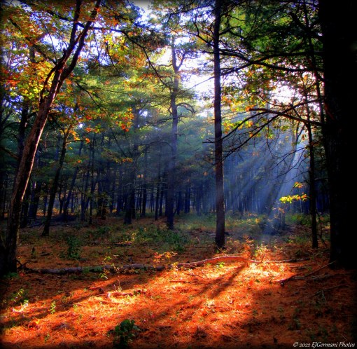
Nestled in the northwest corner of Rhode Island just west of Wallum Lake is the Buck Hill Management Area. This vast piece of property, a haven for hunters and hikers, is pure seclusion. At times you are literally miles from any civilization and it is easy to appreciate what nature has to offer here. I was joined by a group of hikers for this stroll on this gray January morning. The temperatures were bearable, however the trails were very icy, slowing our usual pace. We started from the second parking lot where the gate is. From here we headed north along the access road. Soon we came to the first intersection. We continued straight along the access road. The road to the left would be our return route. We soon crossed a small brook before coming to the next fork. The access road veers to the right. At this point we choose to stay to the left and started following the yellow blazed trail. This trail was rather rocky for most of its length. We then came to an opening on the left. Here is a marsh, part of Lesson Brook. Although we saw none this morning, I would imagine this would be a good spot to view water foul. We continued along the yellow blazed trail passing areas of hemlocks and mountain laurel, passing an old fire road, before coming to an area with some stone walls. Here, atop a rather high hill, looks as if there may have been a structure at one time. We then continued along the yellow trail and came to Old Starr Road. The road is very obvious as it is a small valley between the roads embankments and stone walls. From here we turned left, heading west, down the hill. Soon we came to a fork. We followed the road to the left.  From here we followed this road to its end, winding gently uphill for a bit. The road follows the ridge line of Benson Mountain for about a mile. There are several paths off of the main road that lead to several fields along the way. The road then bears left and downhill to its end. Turning right we retraced our steps along the access road back to the parking area. This area is open to hunting and orange must be worn during hunting season.

Trail map can be found at: Buck Hill.

Frozen Marsh At Buck Hill

Frozen Marsh At Buck Hill

Freetown South – Freetown/Fall River

  • Freetown South – Freetown State Forest
  • Bell Rock Road, Freetown, MA
  • Trailhead: 41°45’33.32″N, 71° 4’17.59″W
  • Last Time Hiked: December 14, 2014
  • Approximate distance hiked: 3.8 miles
  • Fairly easy with some elevation.


EXERCISE EXTREME CAUTION NEAR THE EDGES OF THE CLIFFS.


I ventured into the Freetown State Forest for the first of three planned hikes. This morning I choose to do the southern end of the forest. I was joined by a small group of hikers. We started from a parking area along Bell Rock Road. There are two trail heads here. We took the one by the large sign at the south end of the lot. The trail here is short, narrow, and well rutted from ATV use. It leads to a dirt road named Haskell Path. At the end of the trail we came to a gate. We turned right onto Haskell Path and followed it slightly downhill to a four way intersection with gates, passing several side trails we ignored. At the four way intersection we turned left onto a trail named Ledge Road. The road continues downhill and is flanked by the forest. We soon approached a fork in the road. We stayed to the left and continued to the a small stone bridge that crosses Rattlesnake Brook. (The road to the right would be our return route). After crossing the brook, and crossing briefly into Fall River, the road begins climbing, passing several side paths, as well as the Pond Trail and the Mothers Brook Trail. The road, well worn from the weather in areas, passes through areas of beech and pine trees. At the top of the hill a large area of ledge appears on the right. Use caution in this area. We explored the area enjoying the overlook. The view to the east looks over the pond below and the forest as far as the eye can see. We then returned to the road continuing north and started gradually going downhill. We then took a right onto the next road followed by another almost immediate right. This road leads to the shore of the pond. From here you get a good perspective of how high the ledge is. Here there is an intersection where we would turn left. However, we explored the short road along the edge of the pond before continuing. There are a few spots to enjoy the view here and there is a waterfall as well. We then turned left at the intersection and continued the hike crossing Rattlesnake Brook once again. Shortly after the brook we encountered another fork. The trail to the left is the Wampanoag Path. We stayed to the right passing a rather large gravel pit on the left before reaching the first fork we encountered. Here we went left and retraced our steps back to the parking area.

Trail map can be found at: Freetown South.

The Ledge and Pond

The Ledge and Pond

Barn Island – Stonington

  • Barn Island Wildlife Management Area
  • Palmer Neck Road, Stonington, CT
  • Trailhead: 41°20’22.38″N, 71°52’38.91″W
  • Last Time Hiked: November 30, 2014
  • Approximate distance hiked: 5.0 miles
  • Fairly easy with some slight elevation.


I met up with a fellow blogger this morning for a hike in her neck of the woods. She is quite familiar with the property and has been here several times. This would be my first venture onto this property. Hunting is allowed here but we were able to explore the property without the worry of hunters as hunting is not allowed on Sundays in Connecticut. We started the hike from the parking area by the informational sign and followed the stone dust path as it went downhill through a small section of woods before coming to the tidal flats. In this area there are great views of Little Narragansett Bay beyond the golden grass of the flats. In the distance you can see the Watch Hill Light and Napatree Point. Continuing along the path we headed back into another sections of woods. Here we came to another sign with a map of the property. We went right here leaving the woods and into another area of tidal flats. Here we saw an egret as well as some ducks. We soon turned right at the next intersection onto a grass road. This is actually a spur trail that leads to the eastern edge of the property. Along this stretch we saw a great blue heron and more ducks. The Latimer Reef Light (actually in New York) is visible from here on clear days. We soon found ourselves back in the woods and climbing slightly uphill. Along this stretch are several stone walls and a cemetery with graves dating back to the 1800’s. Soon the trail ends and comes to a paved road. The road, named Brucker Pentway, passes a few homes and the entrance of the Boy Scouts Camp Kitchtau. We turned left onto an unnamed road shortly after the stucco barn. This road led back to the wildlife management area. Passing the gate at the entrance of the property we found ourselves on another grass road. We were surrounded by fields that would be home to wildflowers in the summer months. In the fields were several poles with bluebird houses on them. This road would eventually lead back into the woods. Shortly after entering the woods we came to another intersection. We turned right here. The trail then winds through an area of woods for a while passing several stone walls. There are several narrow side trails along this stretch. It is best to stay on the main trail and go left at all “major” intersections until you return to the sign with the map where we made the first turn. When we reached the sign we turned right and retraced our steps back to the parking area. On the other side of the parking area there is a short spur trail that leads to a small sandy point into the bay. The short walk is worth it for the views.


Trail map can be found at: Barn Island.

Tidal Flats At Barn Island

Tidal Flats At Barn Island