Posts Tagged ‘ State Forest ’

Freetown North – Freetown

  • Freetown North – Freetown/Fall River State Forest
  • Slab Bridge Road, Freetown, MA
  • Trailhead:  41°46’40.01″N, 71° 2’29.59″W
  • Last Time Hiked: June 30, 2018
  • Approximate distance hiked: 4.5 miles
  • Fairly easy.


Three and a half years ago I ventured into the southern part of the Freetown State Forest to do a hike. It was a cold and icy day in mid December of 2014. I finally made my way back to explore some of the trails in the northern part of the forest. This hike, early in the morning to beat the heat, made for a very sweaty adventure on a very warm and humid morning. Starting from the main parking area off of Slab Bridge Road we made our way up the entrance road back to the fire barn and then turned left onto the dirt trail named Payne Road. We followed this road passing a CCC watering hole on the right. Shortly after the watering hole and again on the right we came upon a blue blaze on a trail marker. We turned right here and followed the narrow and winding Massasoit Trail. This trail is rocky and rooted in areas and crosses a small stream. We followed the trail to its end then turned left on to Hathaway Road. There are several side trails off the main roads here but the remainder of the hike is on old forest roads. At the next major intersection of forest roads we continued straight staying on Hathaway Road passing two more watering holes. We also observed along this stretch mosquito traps that are used to test the pests for West Nile Virus and EEE. At the next major intersection we turned right onto Makepeace Road and followed it past the intersecting orange trail before going over a slight hill. Just over that hill we turned left onto the Bent Rim Trail which is marked with a sign. For the remainder of this hike we continued straight ahead followed the Bent Rim Trail as it winded through the forest ignoring all side paths and roads until we reached a trail on the left just before the gate at Slab Bridge Road. This trail leads you back to the parking area.


Map can be found at: Freetown North

TWRI-FSFN05

Old Forest Roads

Wakefield Pond – Burrillville/Thompson

  • Wakefield Pond
  • Wakefield Road, Burrillville, RI
  • Trailhead: 41°58’15.94″N,71°47’51.77″W
  • Last Time Hiked: October 21, 2016
  • Approximate distance hiked: 3.0 miles
  • Moderate due to footing and some elevation.


Wakefield Pond is often overlooked as it lies between some of the more predominate recreational areas. The Buck Hill Management Area to the north, the George Washington Management Area to the south, and the Quaddick State Forest to the west often overshadow this area. The pond is flanked to the west by a Boy Scout Camp and the northeast by a couple dozen homes. This hike is an out and back that follows dirt roads. Starting from the corner of Wakefield Road where it bends onto Croff Road there is a dirt road that heads to the east. Almost immediately you will come upon a historical cemetery on the left. The road then starts to descend downhill, into Thompson, to a four way intersection. Along the way there are a few trails to the left. Notice the “No Trespassing” signs, this is the land of the Boy Scouts. When you have reached to intersection turn left. This is Wakefield Pond Road and it heads south through the Quaddick State Forest for a bit before coming to more Boy Scout property. There is a long steady stretch of uphill walking here. After the top of the hill you will see a cellar hole on the right with an old shed behind it. The road then descends downhill once again and curves to the left heading back into Burrillville after crossing Blackmore Brook. In the distance to the left you will see the stonework of the stone and earthen dam that holds the water in Wakefield Pond. There is a trail to the left that leads to a wooden bridge and dam. This is private property. Continue ahead for a view of the pond. Next there is a road to the right that leads to Peck Pond. For this hike continue straight along the road. At the one and a half mile mark, just as the pond starts to turn away from the pond, there is a nice little spot with a sweeping view of the pond. From here retrace your steps back to the beginning of the hike. The roads that you follow for this hike are rather rocky, some loose in many spots. Beware of your footing.

twri-wakefield

Fall Colors By The Pond.

Rhododendron Sanctuary – Voluntown

If there is one hike in the area that is all about timing it is this one. The short, level, out and back, quarter mile trail leads you through an area of dense rhododendrons. These shrubs bloom in late June to early July and the vast cluster pink flowers are spectacular. The trail is mostly gravel based and boardwalks. Along the trail there are swamps with frogs and turtles. There is also an abundance of ferns covering the forest floor. The trail ceases at Misery Brook. This hike would be a good companion to other nearby hikes including Mount Misery.


Trail maps can be found at: Rhododendron Sanctuary

TWRI-Rhodo

Blooming Rhododendron

Tri State Marker – Thompson/Burrillville/Douglas

  • Tri State Marker
  • East Thompson Road, Thompson, CT
  • Trailhead: 42° 0’31.89″N, 71°48’32.66″W
  • Last Time Hiked: May 20, 2017
  • Approximate distance hiked: 4.2 miles
  • Moderate, difficult in areas with rocky footing and hills, rest is fairly easy.


Upon a knoll deep in the woods is where the states of Rhode Island, Massachusetts, and Connecticut meet. At that point is a granite marker. It is not an uncommon occurrence in the United States. But here it is all on public land and there are trails leading to it. Although this hike was not just to the marker and back, it certainly is one of the highlights of it. This hike would lead us through all three states using various trails. We (myself, Auntie Beak, and a another fellow hiker) started at East Thompson Road where the Airline Trail crosses the road. This would be the first highlight of the hike. At this location on December 4, 1891 the Great East Thompson Train Wreck occurred. It was the only four train collision in the countries history. There is signage here explaining the event. From here we headed east along the Airline Trail. The trail itself is the former railroad bed. It is now just a flat wide dirt and gravel path. We soon came to an old wooden bridge that crossed the path. The bridge was apparently used to herd livestock safely over the railroad. Just after the bridge and to the left is a faint path that leads toward the bridge approach. Here is the next highlight of this hike. It is the Hermit Cave. The small hole in the side of the hill is the entrance to the cave. Inside the cave (flashlight required) is some impressive stonework. No one knows for sure who built it, but it appears to be similar to many root cellars found throughout New England. Continuing on the Airline Trail we soon came to a sign for the blue-blazed Tri State Marker Trail. Here we turned right and started the fairly short (three tenths of a mile) but relatively challenging uphill and rocky climb toward the next highlight of this hike. This trail follows the Connecticut/Massachusetts border. At the top of the trail is a small clearing with a large granite marker. This is the Tri-State marker. The monument, dated 1883, has the abbreviations of the three states inscribed in it. The trail to the right would lead you back to the Airline Trail if you decide you have seen enough. The trail straight ahead, called the Border Trail by locals, would lead you along the Connecticut/Rhode Island border into the heart of the Buck Hill Management area. We opted to follow the trail to the left (east) that follows the Rhode Island/Massachusetts border. We were in the extreme northern edge of Buck Hill along this trail. The trail, still rocky and somewhat difficult, continues to climb uphill, passing a few more state boundary markers along the way. The trail soon ends. We turned left onto the next trail and into the Douglas State Forest. The trail, unblazed and unnamed steadily descends down the opposite side of the hill we just climbed over. The hike from here on is relatively easy as most of the inclines were now behind us. Along this trail we came across the first of some quite impressive cellar holes. At the next intersection we turned left onto the yellow blazed Mid-State Trail. We followed the Mid-State for a while passing yet another impressive cellar hole. The Mid-State then turns to the right (sign on tree says “PARK”), we followed the trail to the left and continued downhill, passing a small stream, to a four way intersection at the Southern New England Trunkline Trail. This trail is a continuation of the railroad bed we came in on. It just has a different name on the Massachusetts side. Before turning left and following the trail back to the car, we did a little exploring to the right and straight ahead checking out some of the water features. Rocky Brook offers some small cascading waterfalls and the pond here was still with some nice reflections. Both Buck Hill in Rhode Island and the Douglas State Forest in Massachusetts are open to hunting. We did come across hunters on this hike. Be sure to wear blaze orange during hunting season.

Trail map can be found at: Tri-State Marker. (courtesy of Auntie Beak)

The Tri-State Marker

The Tri-State Marker

Reflections

Reflections

Hell Hollow – Voluntown/Plainfield

  • Hell Hollow – Pachaug State Forest
  • Hell Hollow Road, Voluntown, CT
  • Trailhead: 41°38’14.19″N, 71°52’9.77″W
  • Last Time Hiked: October 13, 2014
  • Approximate distance hiked: 7.6 miles
  • Moderate due to distance and some rocky footing.


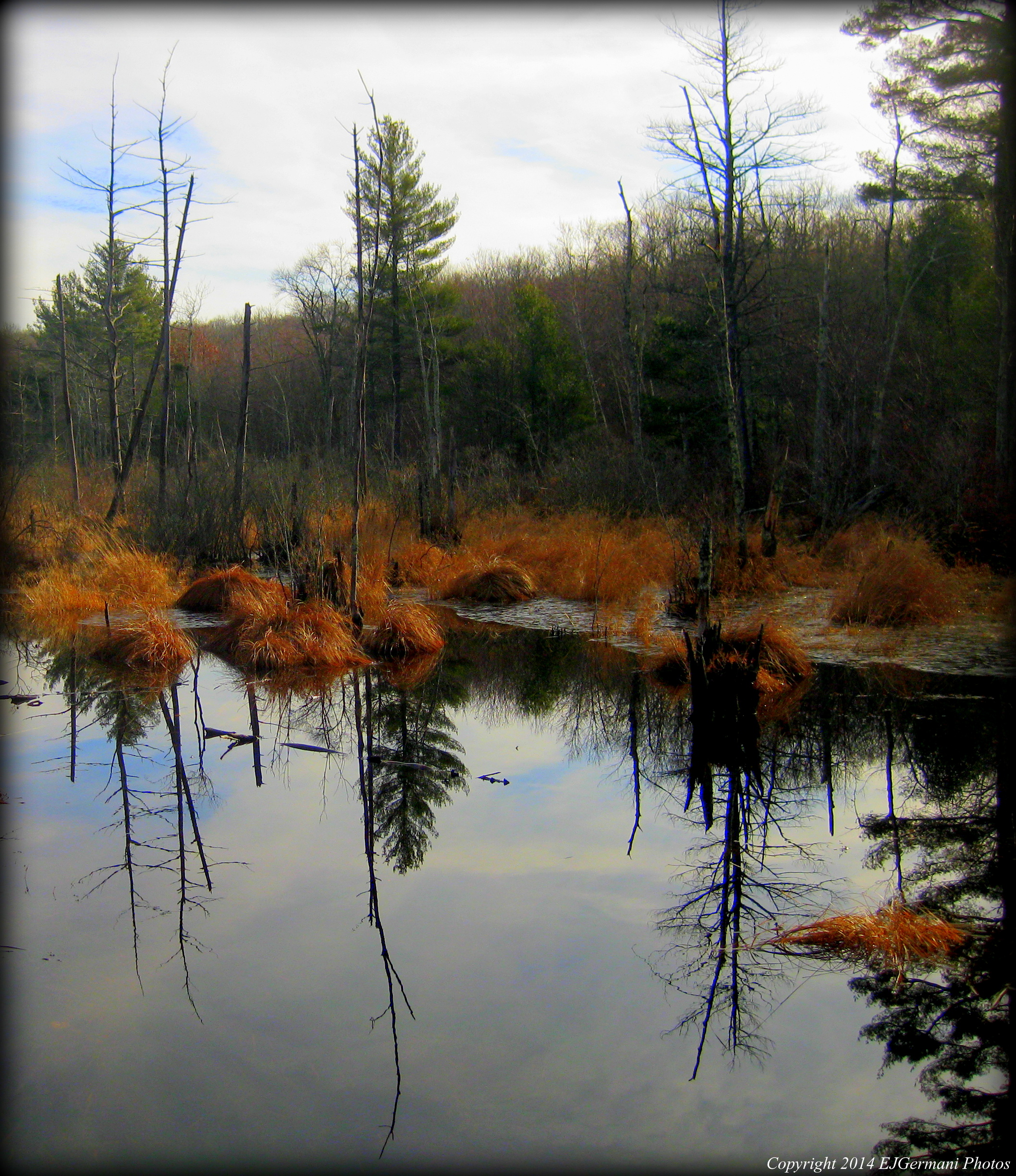
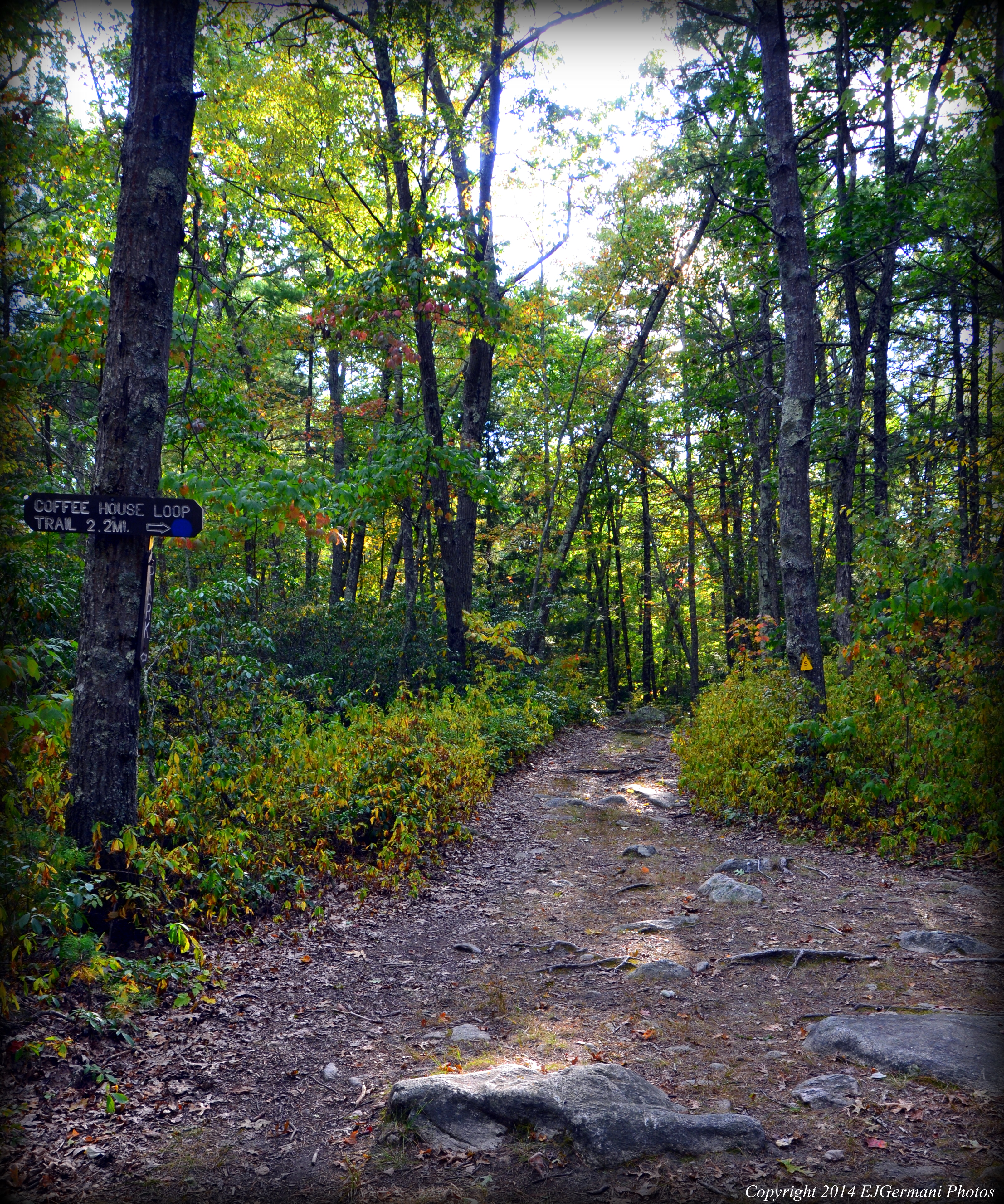
For such a sinister name, Hell Hollow is quite a beautiful place, especially this time of year in Southern New England. Many of the trees here are approaching peak foliage. The splashes of reds, oranges, and yellows make for a nice backdrop of the two ponds along this hike. I joined a fellow hiker/blogger for this hike. We started from a parking area on Hell Hollow Road at the pond. We then headed east along the road about 1/10 of a mile then turned left onto the blue blazed Pachaug Trail. We followed this trail until we reached an intersection with the blue going to the right and yellow to the left. We were now in Plainfield. Here we went left onto the yellow blazed Quinebeag Crossover Trail. The trails here are covered in leaves and can be rocky in areas as they wind through areas of oaks, pines, and stream beds. Be sure to keep an eye on the blazes as the trail becomes a little difficult to follow at times due to ground cover. We did come across a coyote here, unfortunately for this animal, it was just the remains. This section of trail soon ends at Flat Rock Road. We turned left, still following the yellow blazes, and followed the road to a split. Here we stayed to the left and followed the short section of what was left of the yellow blazes. We then found ourselves at the next intersection. This was the Quinebeag Trail. If we were to turn right the trail would lead us to Lockes Meadow Pond. We continued straight (now a blue blazed Quinebeag Trail) still following the aptly named Flat Rock Road. We soon came to areas of ledge that the road traversed over. To the left is a small overlook. At the time of the hike there were to many leaves on the trees, but I was told the view is decent in the winter months. We then continued turning left off of Flat Rock Road following the blue blazes. If you reached the paved road, you have missed the turn. From here we followed the Quinebeag southerly a little over a mile passing a cellar hole at the trail intersection about halfway through this section. The footing is a little tough here as the trail is very rocky in areas. We soon found ourselves back at Hell Hollow Road. (You can turn left here and follow the road back to the car if you want to cut the hike in half.) Here we turned right following the road a bit before turning left into the woods again continuing to follow the blue blazed Quinebeag. The trail then makes a small horseshoe before coming to the next turn. This turn was not easy to find as the trail blazes are quite faint here. A couple hundred feet before the road the Quinebeag turns to the left. It is a very narrow trail along this stretch but still better than walking the road. Fear not though if you can not find it, just follow the road. They run parallel and both come to a picnic area a little over a mile away. After some slight backtracking, we found the trail and carefully proceeded being sure to keep an eye on the blazes. The trail is quite nice meandering at times through a grove of young pines. We did have to cross a rocky area that appears to normally be a difficult stream crossing. We soon came to the picnic area. Here we stopped for a quick break. The picnic area overlooks Phillips Pond which is quite smaller than Hell Hollow Pond. From here we then made our way onto the road crossing the small stream, then left through the parking lot and onto the blue/red blazed Phillips Pond Trail. Soon we were turning left onto the blue blazed Pachaug Trail once again for the final stretch of the hike. Again we were in areas of pine groves. Some of the ground cover included wintergreen, partridge berries, and a variety of mushrooms. At the end of the trail we turned left onto the road and followed it to Hell Hollow Pond where the cars were parked. This area is open to hunting. Orange should be worn during hunting season. Futhermore, sections of Hell Hollow Road are closed from December to March.


Trail map can be found at: Hell Hollow.

Foliage at Hell Hollow Pond

Foliage at Hell Hollow Pond

Coffee House Loop – Douglas

  • Coffee House Loop – Douglas State Forest
  • Wallum Lake Park Road, Douglas, MA
  • Trailhead: 42° 1’21.28″N, 71°46’13.14″W
  • First Time Hiked: September 18, 2014
  • Last Time Hiked: May 7, 2017
  • Approximate distance hiked: 2.2 miles
  • Moderate with slight elevation and some rocky footing.


The calendar indicates that there are 5 days of summer left, but the air is cool and dry, the leaves are showing shades of yellow and red, and the days are getting shorter. Autumn is right around the corner and it was very evident here in the Douglas State Forest. After parking and looking for the trail head (or apparent trail head), we made our way onto the loop trail. The route I took started at a trail that was at a closed parking area. On the right side of the trail is a yellow chain and to the left is a “Do Not Enter” sign for unauthorized vehicles. The dirt road we followed comes to an intersection. We continued in a straight direction following the first sign we found indicating that we were on the Coffee House Loop. From here the trail, sporadically blazed, is relatively is to follow in most places. This section of the loop is fairly straight traversing over a small hill. The trail is quite rocky here and there are several large stones in the woods along the trail. This trail soon meets with the Mid-State Trail. The Coffee House Loop turns right onto the Mid-State. There is a sign at this intersection that indicates this. The next section meanders slightly downhill passing some areas of swamp, crosses over some boardwalks, and then crosses a stream. Then there is a right marked by another sign. This is where it gets a little tricky and I found myself relying heavily on my GPS. In this area the map does not seem to reflect the actual trails here. I came to an intersection that had no indication of which trail was which. There simply wasn’t any blazes. At this point you want to go right and follow this trail to it’s end. There should be a sign on a tree at the end of this trail indicating that the Coffee House Loop turns right. (If you go left you will come out the Southern New England Trunkline Trail). Turning right onto a wide trail we passed a large area of swamp to the left before finding the next sign to turn right. The last stretch winds through the woods before coming to a dirt parking area. The trail follows the edge of the parking area then up a small hill and into the closed parking area where we started. On this hike we saw two deer, several birds, chipmunks, and squirrels. We could also here what I believe to be an owl.


Trail map can be found at: Coffee House Loop.

Where The Coffee House Loop Meets The Mid-State Trail

Where The Coffee House Loop Meets The Mid-State Trail

Rehoboth State Forest – Rehoboth


This hike made for a few milestones. Firstly, without realizing it I hiked in four states in three days. On Saturday I drove to Franconia Notch in New Hampshire, on Sunday I did a series of hikes in Rhode Island and Connecticut, and this evening I hiked here in Massachusetts. Secondarily, this hike put me over the 300 mile mark since I started this blog. I was joined by a co-worker (who is one of the organizers of The Rhode Island Hiking Club). We started this hike following the main path pass the gate into the forest. We passed several narrow paths to the left and one trail to the right (we would return from that trail) following the main trail to its end. There we saw the first of the blue blazes to the right. The trail to the left ended abruptly at a “No Trespassing” sign. We went right following the blue blazes through the woods and some areas of mud. The trail eventually looped back to the main trail. We then did some exploring of the side trails we saw on the way in. There was evidence of a “Tough Mudder” event here. We also came across some lady slippers that were in bloom. It is illegal to remove these flowers. After we explored just about all of the trails we concluded the hike.


Trail map can be found at: Rehoboth State Forest.

Stone Wall At Rehoboth State Forest

Stone Wall At Rehoboth State Forest